Elsewhere in Weather News: September 22nd, 2012

Wildfires Sparked by Dry Lightning Affect Pacific Northwest

A couple large wildfires in the state of Washington have been burning for the past week or so and continue to grow in size. The fires, located in the central and southwestern part of Washington, were sparked by dry lightning a few weeks ago but have only started significantly growing in size this week. The main reason as to why these fires have now become large and uncontrolled can be attributed to the very dry conditions and warm temperatures on the west coast this past month.
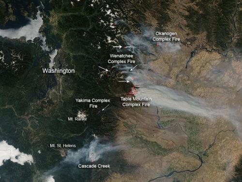
Washington wildfires

Picture of various wildfires across Central Washington. (Source: NASA)

Currently, the largest fire in the state is the Wenatchee Fire Complex which covers around 16,000 hectares, is around 25% contained, and is being battled by over 2,000 firefighters. The second complex of fires, Table Mountain Complex, poses the highest level of threat to residents – causing 1,250 residents to evacuate and currently putting 750 homes at risk. Approximately 700 firefighters were currently at work on that specific fire complex which was only 5% contained as of Thursday. Smoke that has been slowly wafting further away from the fires, has started to affect surrounding communities in Central Washington thereby prompting the issuance of air quality advisories.
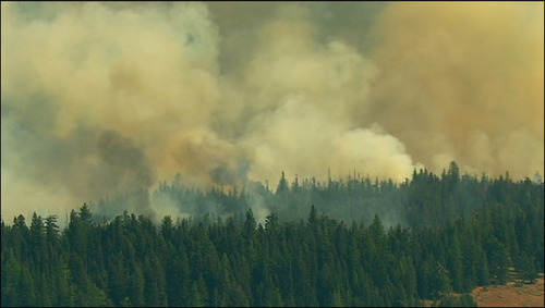
Wildfire

One of the numerous wildfires raging across Central Washington. (Source: KIMATV)

The reason for the unseasonably warm temperatures in Washington and the rest of the west coast this week (approximately 6°C above average) can be linked to a strong ridge of high pressure that has been in place since the start of this week. It appears that the balmy temperatures will stay put through the weekend. Early next week, a weak upper-level disturbance is predicted to slide through the area which could bring some precipitation with it to alleviate the threat of the fires, although it could also cause more trouble than good if more lightning strikes come with the system.
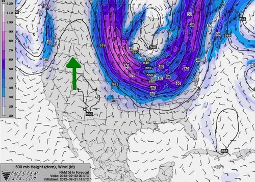
Ridge

Ridge over the west coast (indicated with green arrow) with 500mb winds and heights. (Source: Twisterdata)

Elsewhere in Weather News: September 15th, 2012

Pakistan Monsoon Flooding

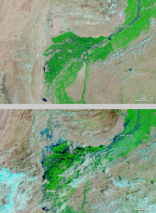
Severe flooding occurred in Pakistan early this past week, after monsoon rains moved into the region and dropped large amounts of rain. Even though Pakistani officials had issued a flood warning for many low-lying areas such as Punjab and Sindh, many residents decided to stay put to battle out the floods in their villages.

As numerous canals and rivers overflowed their banks because of the heavy monsoon rains, many low-lying areas such as farmland, villages and roads were inundated with water. The highest rainfall report that could be found was in Rahimyar Khan where 193mm fell in 24 hours between Sunday the 9th and Monday the 10th.

Pakistan flooding

Two satellite images (visible/IR enhanced) showing the difference between no flooding and severe flooding in Pakistan. Notice the dark blues along the Indus River. (Source: NASA)

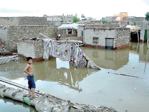
About 1,500 houses were destroyed in the process and over 100 people perished with waters rising quickly and houses collapsing from waters. The country’s army was deployed to execute search and rescue missions in the hardest hit areas, and to try to fill in the areas where water broke through the canals.

Flooding

Picture showing the flooded houses in the town of Larkana located in the region of Sindh. (Source: APP)

Estimated total losses look to be in the neighbourhood of a couple million, though it’s difficult to assess at this time as authorities are still tallying up the damages and looking for survivors. When the floodwaters recede, most likely in a couple days, the final tally from the total economic loss and death toll should be more accurate. This monsoon season does not compare to 2010 though, where numerous severe flooding events occurred and residents described that year as “the worst in living memory”. In 2010 the total structure damage that accounted for four billion in damages and the floods had a significant impact on 20 million people with around 2,000 deaths.

The monsoon rains have since moved away a couple days ago from the region of concern and crews will be able to clean up, repair villages and search for more survivors this weekend.

Elsewhere in Weather News: September 7th, 2012

Tropical Storm Leslie a Threat to Canada

With the hurricane season nearing its peak in the Atlantic, more tropical systems have spun up this past week. The first system which is not much of a concern (unless you are boating in the middle of the Atlantic) is Michael. Michael, once a category three hurricane, the strongest seen this year, has been spinning in the middle of the North Atlantic for a while now and is not expected to make a landfall.

Leslie

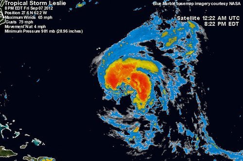
Leslie still not organized very efficiently with a broad circulation on IR satellite as of Friday evening. (Source: Wunderground/NASA)

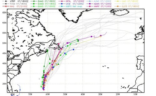
The second storm; Leslie, however, is spinning west of Michael and has a small chance at making a landfall somewhere on the south-eastern coast of Newfoundland, Canada. Bermuda is already experiencing high surf and there’s a good chance they’ll experience tropical storm force winds this Sunday since Leslie is such a large storm. By that time, Leslie will likely be upgraded to hurricane status of category one. It will slowly start moving north as the trough moving in from Eastern Canada approaches the storm. Though, with that said, Leslie still stands a slim chance at making landfall on Canadian soil and making a significant impact on the province. Since this possibility is still quite a ways away – five to six days – weather models are having trouble deciphering Leslie’s exact future track.

Leslie tracks

Model consensus appears to be leaning towards no landfall and more of a rain event for Newfoundland. (Source: SFWMD)

Even though Leslie might come close to Newfoundland within the next week or so, it appears the worst part of the storm will be well off to the east of the island as the top right quadrant of the storm where the strongest winds are located is not expected to affect land. The last time Newfoundland got struck by a tropical disturbance was back in October of last year where tropical storm Ophelia struck, dumping heavy rains on the Avalon Peninsula of Newfoundland. The most memorable hurricane to affect Newfoundland in recent memory had to have been Hurricane Igor, in 2008. This hurricane caused severe flooding to the eastern half of Newfoundland where in St. Lawrence, NFLD, 238mm fell. This was the most damaging hurricane to have ever hit Newfoundland in recent history.

Updates on Leslie will be forthcoming as it nears Canada!

Elsewhere in Weather News: September 1st, 2012

Tropical Depression Isaac: Update

What was once dubbed Hurricane Isaac when it made landfall as a category one hurricane, is now considered a ‘tropical depression’. Isaac continues to pose a threat a week after it made landfall but it has weakened significantly, and will continue to do so, as it penetrates further into the southern half of Continental United States. Although this hurricane was “only” rated a category one when it made landfall, comprising of maximum sustained winds of 135km/h at peak intensity, you would have not guessed the incredible amounts of rain it brought into Louisiana and surrounding Gulf States. Here are a couple of the most impressive rainfall totals recorded throughout the whole event:

-In Gretna, LA, the National Hurricane Center (NHC) unofficially reported 466mm of rainfall.
-In New Orleans, LA, 510mm of rainfall was reported, breaking New Orleans’ old daily rainfall record by 48mm (a record thsat was set by Hurricane Katrina).
-In Kiln, MS (west of Gulfport) 433mm of rainfall was reported.

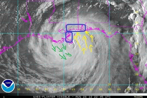
Not only did Hurricane Isaac bring with it enormous amounts of rain, the storm surge that accompanied it was quite severe. Wind-driven storm surge is mostly caused by the severe winds accompanying a hurricane. These winds push ocean waters towards land similar to a wave but larger in size (in this case with south winds) and in turn, ocean levels are higher than the normal tide. This phenomena makes for serious flooding along the Gulf Coast since the terrain along the Gulf of Mexico is not mountainuous – it is more of a gradual slope. When ocean water then rises, it is easy for it to move inland quickly.

Isaac storm surge

Hurricane Isaac’s wind direction depicted with arrows. Blue boxes along the shoreline show areas where winds were favorable for storm surge. Green arrows (north winds) is where storm surge was less favorable because of the wind direction. Picture was taken just before landfall on the night of August 28th. (Source: NOAA)

In Louisiana, two people lost their lives in the Plaquemines Parish, one of the hardest hit parishes, as the tide rolled in and consumed their house. This now brings the Hurricane Isaac death toll in the United States to four, with damages listed in the hundreds of millions. In Louisiana and Mississippi, power was out to over a million people and it was estimated that 75% of New Orleans was out of power when the eye wall passed closest to the city. For a storm being of weak category one, it did an extensive amount of damage. This was in part caused by it’s broad area of precipitation, large area extending out from the eye of tropical storm force winds, extremely slow movement, and storm surge levels you would expect form a category two or three hurricane.

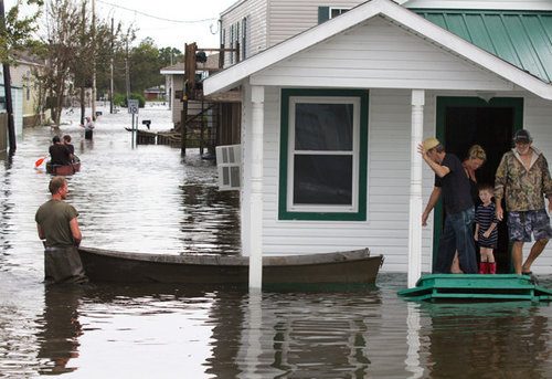
Flooding

Residents evacuating in Lafitte, LA by boat because of flooding. (Source: Yahoo News)

This week in the tropics there are three other notable storms: Hurricane Kirk out in the middle of the Atlantic which poses no threat to land; Tropical Storm Leslie which does not pose a threat to the United States but as it strengthens, could pose a threat to Bremuda; and lastly, Hurricane Ileana out in the Eastern Pacific poses no threat to land but could cause high surf to the Baja Peninsula.