Elsewhere in Weather News: August 25th, 2012

Isaac Threatens Southern States

This past week a tropical disturbance in the central Atlantic, east of the Caribbean, has strengthened into a tropical storm – Isaac. As of Friday night, Isaac had sustained winds of 112km/h, a central pressure of 990mb and was eyeing (no pun intended) Haiti. It is especially worrisome that Isaac, a strong tropical storm, is moving towards one of the most impoverished countries in the world, where nearly 400,000 people are still living in tents after the major earthquake back in 2010.
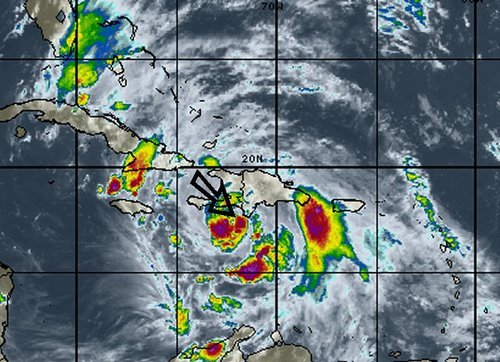
Isaac

Isaac on infrared satellite with centre of circulation identified by arrow. Purple, red represents very cold cloud tops. (Source: WSI)

Isaac will make landfall as a strong tropical storm as it crosses Haiti and then heads toward Cuba. It might have trouble sustaining its strength due to the mountainous terrain of the islands but as it emerges into the Gulf of Mexico, Isaac should organize itself quickly as it takes aim at the Gulf States such as Florida, Alabama, Mississippi and Louisiana. It is expected that Isaac will make landfall on American soil, somewhere on the western part of the Florida Panhandle on Tuesday afternoon. By that time Isaac will have intensified enough to be of hurricane strength, most likely category one. Residents of the Gulf States will have to monitor conditions closely to secure items outside and be ready to evacuate; storm surge along the coast and flooding because of the heavy rains is likely to occur. It will not be uncommon to see rainfall amounts of 100-200mm in the hardest hit areas in the Caribbean and US, however, the more rugged terrain of the islands on the Caribbean could have more devastating effects; landslides and flash flooding.
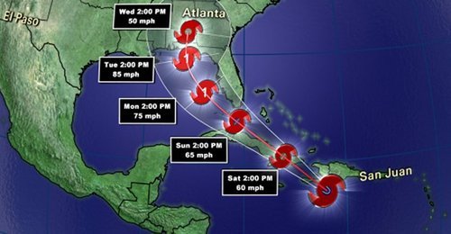
Isaac track

Isaac’s projected track. (Source: News 13)

In other news around the world, Taiwan has been hit with yet another storm – typhoon Tembin that had sustained winds of 155km/h but struck a less populated area of the country, leaving the large cities like Taipei with only minor flooding and wind damage.
Elsewhere in Weather News: August 18th, 2012

A Look Worldwide into July, 2012

As reported on Friday, Winnipeg is shaping up to be one of the hottest years since record-keeping began 139 years ago, with July closing out as the 5th hottest month on record for the city. Wondering how the rest of the world faired this past month?

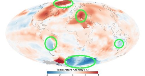
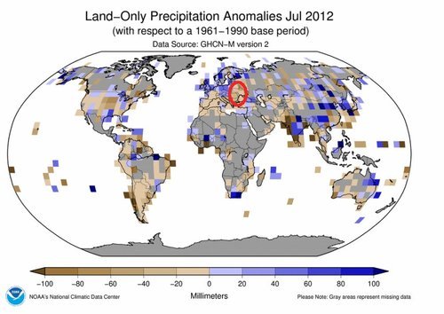
Interestingly, most of the Northern Hemisphere has also experienced extreme temperature anomalies this year. According to the National Climactic Data Center (NCDC), the Northern Hemisphere land surface temperatures this July were 1.19°C above the average, making July 2012 the warmest July in the Northern Hemisphere ever. This year has experienced no shortage of record breaking temps in the Northern Hemisphere – it is now the fourth month in a row that surface land temperature records in this hemisphere have been broken. Canada and the United States have contributed greatly to the record-shattering numbers these past four months but the heat wasn’t confined to North America. South-Eastern Europe has seen conditions almost identical to ours this summer – very dry with record-setting warmth; while Serbia and Bulgaria have been impacted with severe drought this growing season, resulting in severe crop losses. Bulgaria has lost around 10% of its wheat crops due to the sizzling heat, and their maize crops have decimated to the point whereby getting half their average crop will have to suffice. The only countries in the world to have shown significant temperatures below normal this July were Australia, Argentina and parts of the Antarctic.

Temperature anomalies July 2012

July temperature anomalies and circled, areas talked about in EIWN. (Source: NASA Earth Observatory)

Precipitation anomalies July 2012

Precipitation anomalies for July 2012 and circled in red is where severe drought is occurring in South-Eastern Europe. (Source: NCDC)

Arctic Melting

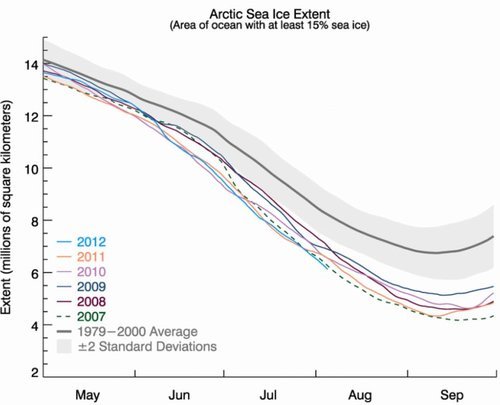
In some areas of the Arctic, July temperatures have exceeded 6°C above average. Arctic ice is continuing to melt at a disturbing rate. The expanse of the Arctic sea’s ice coverage is now at its lowest ever at this time of the year, having dropped even further than measurements from the record-setting year, 2007. In July, almost all of Greenland’s entire ice sheet experienced melting – a “rare event” as described by the National Snow & Ice Data Center (NSIDC). To put things into perspective, sea ice used to reach seven million square kilometers in the 1990s at their minimum, while it has only surpassed five million square kilometers once in the past six years (showing a 29% decrease of minimum sea ice extent in the last few decades). This has lead scientists, like Walt Meier, a scientist at NSIDC, to believe that sea ice could potentially be eliminated by the year 2030 if melting continues at this pace. If this does happen, the ice melt could trigger a domino effect: raising ocean levels, releasing methane from frozen soils, and so on.

Sea ice extent graph

Sea ice extent by year. (Source: NSIDC)

Elsewhere in Weather News: August 11th, 2012

Barrage of Typhoons Continue to Impact Asia

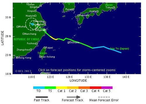
Haikui, the third typhoon to hit China this month, made landfall on Wednesday affecting over 100,000 people on China’s east coast. Rain, rain and more rain is what the region has experienced these past few weeks as typhoons Saola, Damray and Vincente (reported in previous EIWN posts) have all made landfall. On top of the severe rains brought on by these recent typhoons, Haikui has dumped an additional 200mm in areas where the grounds were already extremely saturated – inland flooding now adding another element of concern for residents.

Haikui track

Haikui’s track as it made landfall on China’s east coast. Forecasted track was as of Wednesday August 8th. (Source: TSR)

Thanks to China’s meteorological authorities who issued a red code warning (most severe) for the city of Shanghai well ahead of the typhoon hitting, many lives were saved as residents had time to vacate the premises. Authorities helped relocate over a million and a half people, mostly from the Shanghai region, before Haikui made landfall, further lessening the risk of casualties in the areas prone to flooding and landslides. Storm surge was also a concern for townships along China’s east coast.

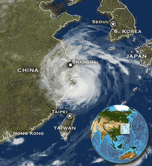
Haikui

Satellite picture of Haikui as it made landfall just south of Shanghai. (Source: Earthweek)

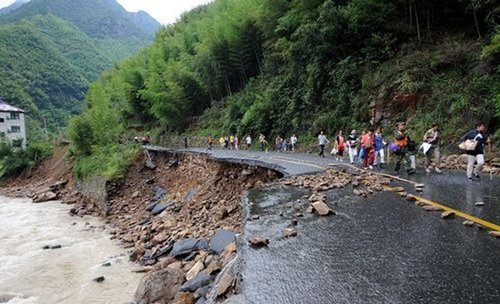
In all, about one million acres of cropland and over six million of China’s residents have been impacted by this major typhoon. Flood damage has been extensive, ranging from roads washed out and stranding tourists and local residents, to homes being washed away by the flash floods. Estimated damage costs from this most recent typhoon are pegged at around the 1.5 billion dollars.

Haikui damage

One of many washed out roads caused by flash flooding in the Zhejiang Province. (Source: Global Times)

Six casualties have been associated with typhoon Haiku to date, however the death toll from the barrage of typhoons since the beginning of July, combined with heavy rains affecting the region, has brought the toll to over 100 people.

Elsewhere in Weather News: August 4th, 2012

Another Typhoon Churns in the Pacific

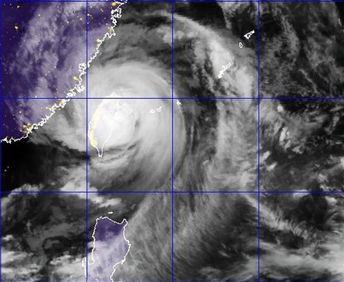
Yet another typhoon, Saola, has made landfall in the Western Pacific this past week, this time hitting Taiwan hard. The “disturbed area” talked about in last week’s EIWN is the culprit for producing typhoon Saola, which made landfall Wednesday, August 1st (Thursday August 2nd Taiwan time), bore winds of around 155km/h. The capital city of Taipei was completely shut down because of this typhoon: financial markets were closed, all businesses were closed, and residents urged to stay inside.

Saola

Typhoon Saola just as the strongest part of the storm made landfall on Taiwan (taken August 1, 2:32pm). (Source: NEXSAT Satellite)

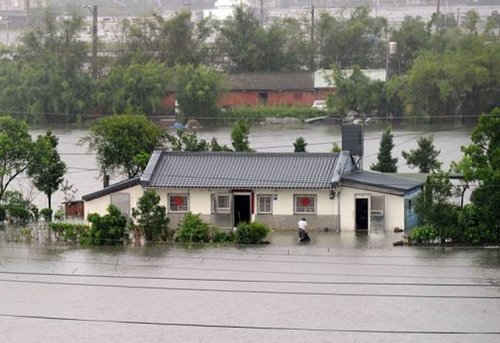
Saola swamped streets and downed large trees as it passed over Taiwan, not to mention the enormous amounts of rain it dumped. Since Tuesday, some areas of Taiwan have received more than 1,000mm of rainfall – that’s about double our yearly amounts here in Winnipeg! The death toll from the extreme flooding Saola caused has reached 27, mostly Taiwan and Philippine residents. The flood waters are still receding and in turn more casualties may be discovered. Taiwan has deployed 48,000 soldiers to the area to help with the cleanup of Taipei and surrounding regions, and rescue teams are also currently hard at work. The typhoon has disrupted flights going in and out of Taiwan and caused chaos in the railway industry.

Flooding

Snapshot of the flooding Saola caused in Taiwan. (Source: AFP)

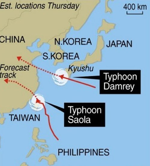
Unfortunately, typhoons don’t seem to be letting up in this already battered region of the Pacific where yet another typhoon has spawned east of China and will make landfall somewhere north of Shanghai. Saola will continue west and is predicted to make a second landfall west of Taiwan on China’s south-east coast on Friday (Winnipeg time).

Typhoons

The tracks of typhoon Saola/Damray as of Thursday evening. (Source: HKO)

In other hurricane-related news (Atlantic basin), a tropical storm, Ernesto, has spawned in the Atlantic eyeing to the Carribean where it will dump massive amounts of rain on the Lesser Antillies. Early Thursday morning a 101km/h gust was recorded at St Lucia where a tropical storm warning has been issued for the Lesser Antillies and residents have bunkered down. Ernesto is expected to make a north northwesterly track and most models show it ending up in the southern Gulf of Mexico by early next week. However, that is still a ways away and hurricanes can sometimes make unpredictable turns, in consequence, a constant eye needs to be kept on the most current satellite and model data.