The weather will gradually turn more unsettled in Winnipeg over the coming few days, although temperatures will continue to remain mild, making for relatively pleasant spring weather.
Today will be another dry day with mild temperatures in Winnipeg as temperatures climb to a high near 17°C with light winds. Skies will start off sunny, but more cloud will build into the region through the day. Skies will remain fairly cloudy tonight as temperatures drop to a low near 4°C.
Tuesday will mark the transition into a slightly more unsettled pattern as multiple weak low pressure systems begin working through the area. Skies will mixed as temperatures climb to a high around 16°C. Through the afternoon, there will be a chance of seeing some showers as daytime heating leads to some pop-up convection. The showers will be relatively weak, though, and no significant amounts are expected. Skies will remain mixed on Tuesday night with a continued slight chance for some showers as temperatures drop to a low near 4°C.
The GDPS is showing an area of showers across Southern Manitoba on Tuesday and Wednesday.
Wednesday will, once again, feature a high near 16°C and a continued chance for showers as another weak disturbance moves through the region. Expect a low near 4°C again on Wednesday night with a continued chance for light shower activity.
Long Range
The remainder of the week looks mild and dry, with conditions stabilizing on Thursday and warmer air pushing in on Friday. Skies look like they’ll remain at least partly cloudy to mixed, but all in all, lovely weather ahead.
Winnipeg’s seasonal daytime high is currently 16°C while the seasonal overnight low is 2°C.
The coming days will bring an end to the persistent blustery north-northeast winds and a return to seasonal temperatures.
Temperatures will remain a bit cool today as a breezy northerly wind persists for one more day, continuing to tap into cooler Arctic air. Temperatures will climb to a high near 10°C with northerly winds increasing to 30-40 km/h. While it won’t be as windy as yesterday—winds reached peak of 52 gusting 69 km/h in the afternoon—the wind will still be fairly noticeable and making it feel cool. Skies will be partly cloudy as Winnipeg lies on the edge of the cloud shield of the departing Ontario low that has been largely shaping our weather the past few days.
Expect a low near -2°C under mainly clear skies tonight with light winds.
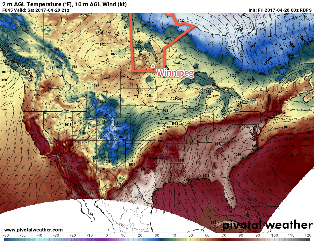
Temperatures will return to seasonal values for Saturday across Southern Manitoba
Saturday will be a welcome break from the weather of the past week with mainly sunny skies sending temperatures to a high near 15°C. Winds will start off light, but pick up to around 30 km/h out of the south for the afternoon as a weak disturbance tracks through the Interlake.
Expect a low near 3°C on Saturday night with diminishing winds and mainly clear skies.
Sunday will be more of the same with plenty of sunshine, a high near 16°C and light winds.
Long Range
The long-range forecast looks like a bit of a mixed bag. Temperatures will return to slightly below-seasonal with daytime highs in the low teens and variable cloudiness. It appears that by mid-week, conditions may begin to get a little more unsettled as another major low pressure system moves through Ontario while a secondary storm track across the Prairies begins getting more active. At this point, no big storms are on the horizon, but it’s worth noting we may see an increased chance for precipitation through the second half of next week.
Enjoy the weekend!
Winnipeg’s seasonal daytime high is currently 15°C while the seasonal overnight low is 2°C.
The weather will be cool and quiet across the Red River Valley through the remainder of the work week.
Winnipeg and the Red River Valley will be wedged between a ridge of high pressure anchored over western Manitoba and a train of low pressure systems moving into Northern Ontario. While it appeared earlier in the week that some precipitation associated with the low pressure systems would work its way westward into the Red River Valley from Ontario, more recent model runs have been producing a more sensible solution that keeps everything off to the east.
That said, Winnipeg & the Red River Valley will see cloud cover associated with these systems. Today will be the cloudiest of the next three with much of the day seeing mainly cloudy skies. Skies will progress to mixed on Thursday, and then we’ll finally see straight sunshine again on Friday.
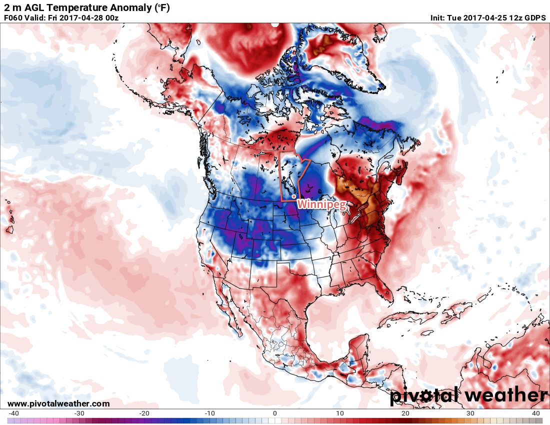
The current weather pattern is bringing below-normal temperatures to a large swath of North America.
Temperatures will remain cool, though, as the ridge and low pattern maintain a northerly flow over the region that continues to tap a cooler air mass to the north. The high temperature both today and tomorrow will hover near 6 or 7°C, with low temperatures near -5 or -6°C both Wednesday night and Thursday night. Friday may end up slightly warmer with a high near 8 or 9°C, but don’t expect anything too far removed from today or tomorrow.
The wind will continue to be quite breezy today, up to around 30 gusting to 50 km/h. They will persist until this evening, when they’ll diminish for the night, then make a reappearance for Thursday. Winds will be much lighter on Friday.
Long Range
This weekend will bring more of the same, except slightly warmer. Temperatures should edge towards more seasonal values under fairly sunny skies, although Saturday may end up more mixed than sunny.
Winnipeg’s seasonal daytime high is currently 14°C while the seasonal overnight low is 1°C.
A developing winter storm will bring moderate-to-heavy snowfall to southern Manitoba beginning early Monday morning. The storm system will primarily affect the Red River Valley and areas east, bringing a fair amount of wet, heavy snow to the region.
Monday’s main story will the snow that moves across the region, supported by a developing low pressure system lifting northeastwards through the Dakotas. The area of snow will rapidly develop overnight, first across western North Dakota, then expanding quickly northwards.
The snow will fall throughout much of the day in the Red River Valley, and into the evening over southeastern portions of the province. It will fall mainly as snow, except for the far southeastern portion of the province—particularly in the Sprague area—where it may become mixed with ice pellets or rain as warmer air wraps in just north of the low.
AWM Snowfall Outlook for Monday April 24, 2017
By the time the snow tapers off this evening much of the south-central and southeastern portion of the province will see between 5-10 cm of snow. The Whiteshell region will likely see 10-15 cm of snow.
Potential Forecast Issues: There are a few potential sticky spots for the forecast. The first hinges on temperatures, which are largely expected to be hovering near the freezing mark. If things end up a bit warmer, snowfall totals will be reduced, either due to lower snow-to-liquid ratios and increased melting/compaction of the snow, or via greater mixing of rain. If temperatures end up dropping a bit cooler than expected, snowfall amounts will bump up a bit, but the greatest impact would be in Sprague, which would go from “near 10 cm with mixed precipitation” to “10-20 cm of heavy snow.”
The most likely snowfall amount for Winnipeg is likely in the 7-10 cm range, with a very small chance of creeping up to 11 or 12 cm. While this may seem like a pretty notable snow, it’s not very significant in the grand scheme of things and doesn’t even register on the top 10 largest daily snowfalls after April 15th:
Top 10 Largest Daily Snowfalls After April 15 (Winnipeg 1872-2016)
Winds will pick up out of the northeast early Monday to around 30 km/h and remain at that strength for quite a while, gradually shifting to the north by Monday evening and then persisting through Tuesday until tapering off on Tuesday night. Temperatures will drop to a low near -3°C on Monday night, climb to a cloudy high near +3°C on Tuesday and then drop back to a low near -6°C under mixed skies on Tuesday night.
The cloudy skies and cooler temperatures will slow the snow melt over the region, and as a result the snow will likely stick around longer than Friday’s snowfall did. However, the sun should poke a bit on Wednesday which, when combined with a slightly warmer high near 4°C, should be enough to melt the snow.
We’ll be keeping an eye on new runs of weather models as they roll in later tonight and update this post if there’s a significant shift in the snowfall forecast.
Long Range
Cooler-than-normal temperatures will persist through the remainder of the week with daytime highs of 5-9°C remaining below the seasonal average of 14-15°C.
Winnipeg may see some more rain or snow on Thursday as a large low pressure system lifts into Northern Ontario and may spread precipitation westwards into Manitoba; this seems relatively unlikely, but it’s worth being aware of as an outside possibility.
Things should settle down for the weekend with a return towards seasonal temperatures, however long range models show the potential for another system Sunday night into Monday that could bring more rain and snow into the region.
Winnipeg’s seasonal daytime high is currently 14°C while the seasonal overnight low is 1°C.