Alberta Clipper Plunges Manitoba into the Deep Freeze

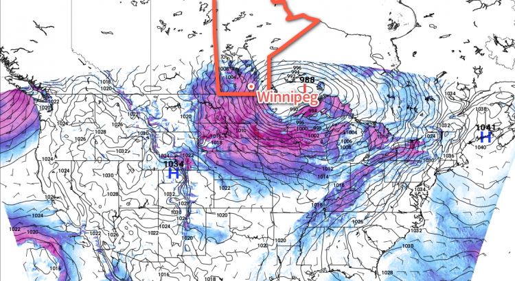
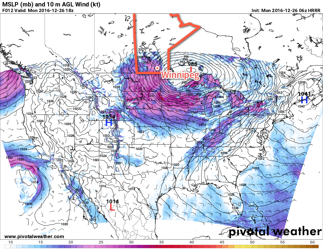
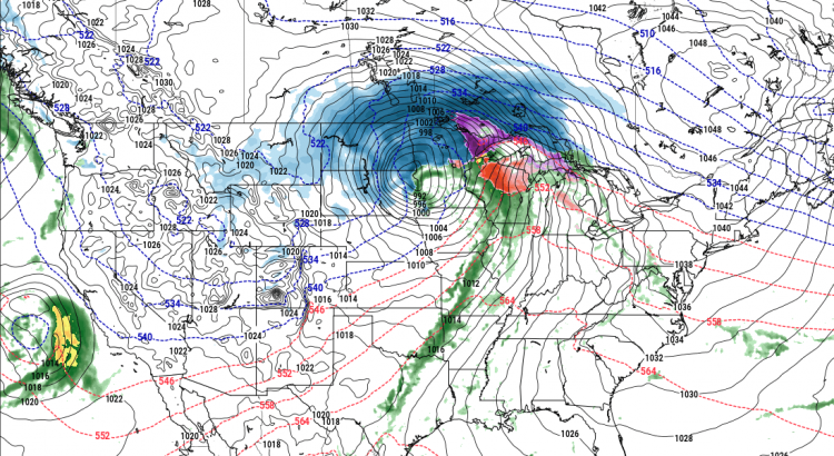
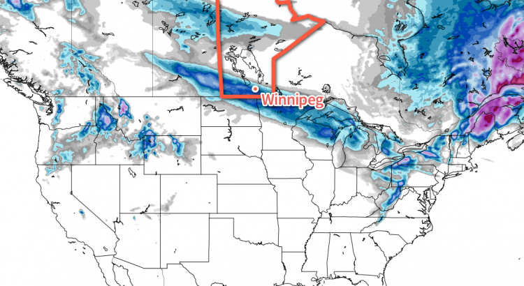
An Alberta Clipper crossing the province today will bring another accumulating snowfall to the region and then usher in a major pattern change that will plunge Central Canada into a deep freeze.

Snow is on tap today for all of the Red River Valley courtesy an Alberta Clipper moving through the region. Snow will spread eastwards through the morning, moving into the Red River Valley between 9AM and 12PM. Snow will persist until the early evening before tapering off.

A large area of 5-10cm of snow is expected today, with a narrow swath likely receiving just over 10cm.

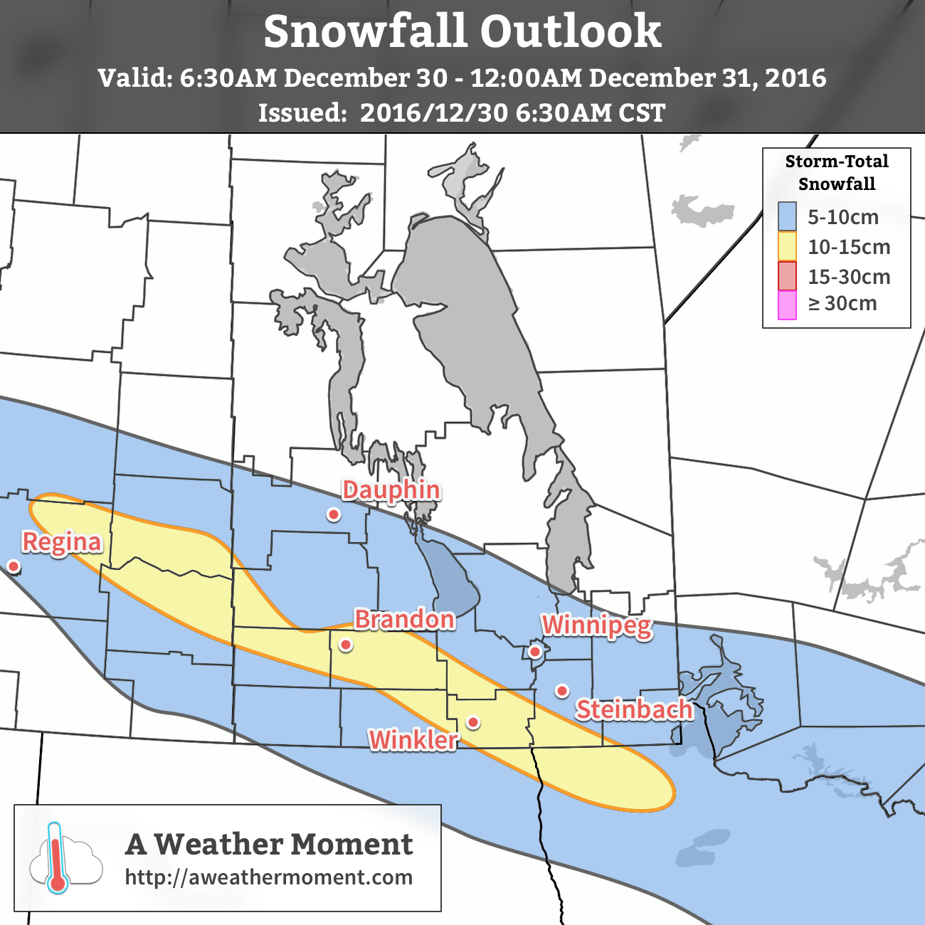
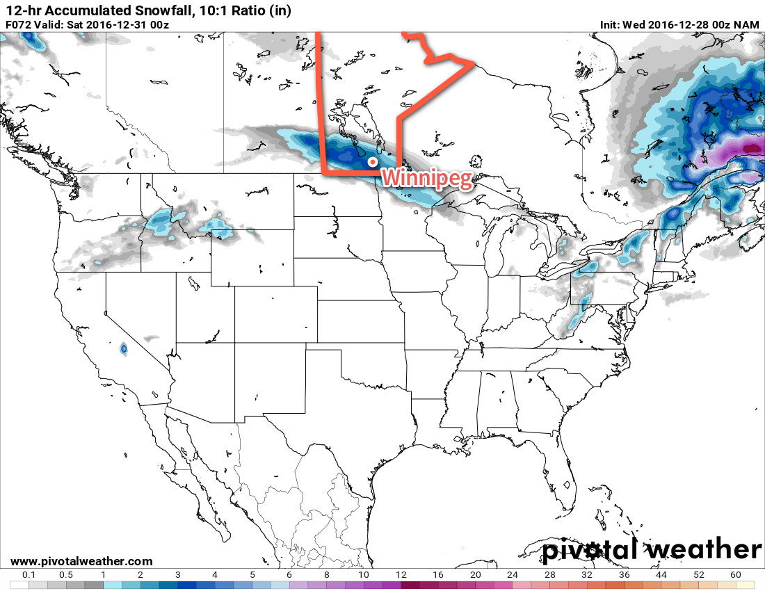
By the time all is said and done most areas along the swath of snowfall will see between 5-10 cm of new snow, however a swath running from Brandon east-southeast through the southern Red River Valley will likely see slightly over 10 cm.

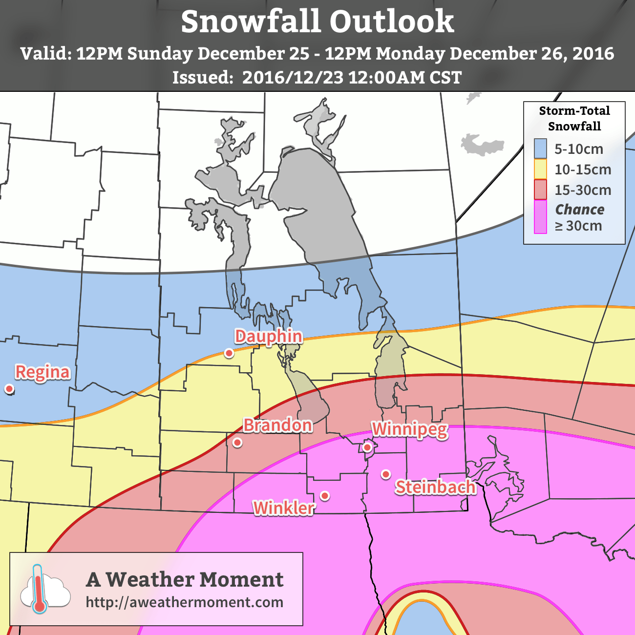
This snowfall comes hot on the heels of a major winter storm that dumped 18-33 cm of snow in Winnipeg on Monday.

Aside from the snow, today will be a little warmer than normal with a high near -10°C. Particularly in the morning, a southeasterly wind of 15-25 km/h will make it feel rather chilly. Winds will ease through the afternoon as they back to north-northwesterly by late this evening. Skies will remain mixed to cloudy overnight with lows dropping to around the -18°C mark.

Saturday will bring mixed to cloudy skies in the morning, with thicker cloud cover and a chance of flurries moving into the region in the afternoon as another low pressure system slumps down from the northwest. Temperatures will continue to be seasonably mild with highs near the -8°C mark. With the new system cloud moving in for the afternoon, a chance of flurries will return to the region. No significant accumulations are expected with this system, but there may end up being enough to get a slight layer on your windshield. The cloud and chance of flurries will continue overnight as temperatures drop to a mild -12°C.

Sunday will start off with cloud and a chance of flurries, but that will clear out through midday as a very broad cold front pushes southwards. Highs will recover a couple degrees from the overnight low to around -10°C, but temperatures will begin dropping sharply when the cloud clears out in the afternoon and colder air begins working in from the north. Lows are expected to drop to around -22°C on Sunday night under clear to partly cloudy skies.

Prairies Fall Into An Arctic Grip

The big story for next week will be the dramatic pattern shift which plunges bitterly cold air southwards across the Prairies and produces daytime highs 5-10°C below normal for this time of year.

Climate Prediction Center’s 6-10 Day Temperature Anomaly Outlook valid January 4-9, 2016

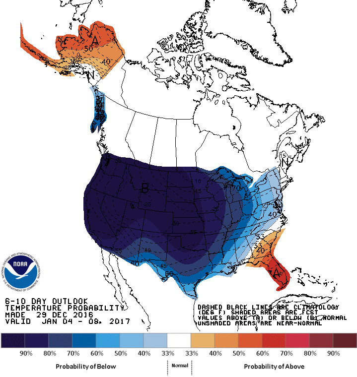
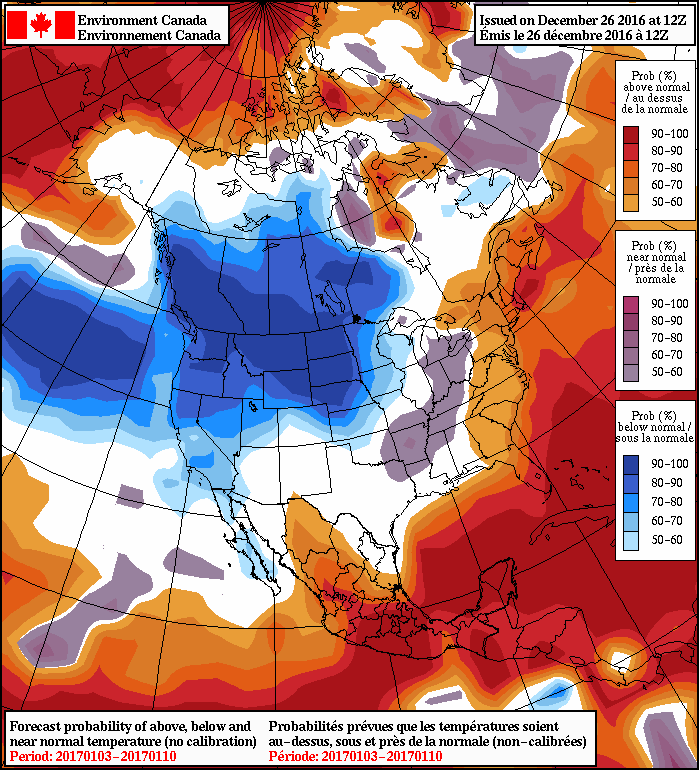
Daytime highs are expected to fall through the first half of the week from the mid-minus teens towards the -22 to -24°C range for the second half of the week. Overnight lows are a bit of a trickier challenge as there’s not a lot of certainty as to how much clearing we’ll see, and overnight cloud cover can dramatically impact how cold it gets. There is very high confidence in this cold snap as shown in the above CPC1 graphic, which has a ≥90% chance for below-normal temperatures across much of the western United States (and by extension, the southern Canadian Prairies). This is the largest extent of 90% probability of below-normal temperatures in the 15-year history of this outlook.

NAEFS 8-14 Day Temperature Anomaly Forecast — Valid January 6-13, 2017

The cold weather is expected to persist into the following week as well, but may begin abating in the 10-14 day range.


  1. Climate Prediction Center 

A Mixed Bag Heading Towards the New Year

Winnipeg will see a bit of a mixed bag over the next few days with some light flurries, some sun, and more accumulating snow on the way.

Today will bring some light flurries to the region as a weak disturbance moves out of the Red River Valley. Accumulations are expected to be minimal, and the light snow will taper off towards the afternoon as the clouds begin pushing off to the east, allowing a bit of sunshine through the afternoon in Winnipeg. Temperatures will be much milder than yesterday with highs near -4°C, but winds will be quite breezy out of the west to around 30 km/h.

Tonight will bring more cloud across the Red River Valley as temperatures drop to a low near -10°C with a northwest wind at 20-30 km/h.

For Thursday, Winnipeg will be under a weak ridge of high pressure. This will bring an end to the flurries, but won’t have enough “oomph” to actually completely clear things out. Skies will likely remain mixed—with perhaps some afternoon clearing—through the day. Temperatures will be a bit cooler than Wednesday with a high near -8°C. Thursday night will bring increasing cloud and a low near -16°C while winds pick up out of the southeast to around 20 km/h ahead of the next incoming weather system.

The NAM shows a swath of 2-3″ of snow (5-8cm) across Southern Manitoba on Friday.

An Alberta Clipper moving through on Friday will bring cloudy skies with snow that starts by mid-morning and persists through to the evening. Temperatures will climb to a high near -8°C with winds tapering off in the afternoon. By the time the snow stops, another 4-8 cm of the stuff will have fallen. Skies will remain mostly cloudy on Friday night with temperatures falling to a low near -17°C.

Long Range

The weekend is looking fairly seasonal for late December in Winnipeg. Saturday will bring mixed to mostly cloudy skies and a high around the -12°C mark. A disturbance moving through Saturday night will bring a chance of flurries and mark the start of a pattern change. Temperatures will slowly fall through the day on Sunday with a brisk northerly wind.

NAEFS 8-14 Day Temperature Anomaly Forecast — Valid January 3 – 10, 2017

Colder weather is on tap for next week as the Polar Vortex re-establishes itself over the central Canadian Arctic, allowing much colder air to slump southwards. Daytime highs next week will fall into the -20’s with overnight lows approaching -30°C.

This transition will mark a change that will likely persist through the first half of January. Although short1 warm-ups to near-seasonal values are possible, temperatures will largely be below-normal and quite cold.

Winnipeg’s seasonal daytime high is currently -12°C while the seasonal overnight low is -23°C.


  1. Perhaps a single day or so. 

Blizzard Ending, Then Much Calmer Weather

The blizzard that has brought much of southern Manitoba to a halt will end today, making way for much calmer weather.

This Week

The crippling blizzard that began last night will gradually end today. Winds this morning will be northwesterly at 40 km/h gusting to 60 km/h, decreasing as the day progresses. Snowfall will end from west to east across southern Manitoba this morning, which will also help to improve visibility. Skies will remain cloudy through the afternoon, with just a lingering chance of flurries. Roads beyond the major routes will likely be impassable today as snow drifts will be significant in many exposed areas. Luckily, calmer weather is expected for the rest of the week, giving folks a chance to recover from yet another significant December blizzard.

HRRR forecast 10m wind speeds valid 18Z Monday December 26, 2016

Tuesday will be a fairly typical winter day with high temperatures in the mid minus teens and a mixture of sun and cloud. Winds will be fairly light, helping to keep wind chill values at bay. Thankfully, this should provide decent weather for those still shoveling out from the storm.

A rapid warm-up will occur on Wednesday as a fast-moving system pushes a warm front across southern Manitoba. This front will push temperatures up close to the freezing mark in many areas, although temperatures for most of the day will be just below zero. This frontal passage may be associated with a bit of snow, but amounts will be small if there’s any accumulation at all.

Long Range

Temperatures in southern Manitoba look to follow a bit of a roller-coaster pattern for the remainder of the week. Another cool-down is expected late this week, before another possible warm-up rolls through for the weekend. This pattern may persist for the remainder of the month before a much extensive arctic air mass moves in for early January.

Forecaster Note

This will be my last regular Monday post at A Weather Moment. I have enjoyed writing my weekly forecast here, but new opportunities mean it’s time for me to give up my regular role. Thanks those that have ready my articles here every week for the past 5 years. I’ll still be a part of AWM, but in a lesser capacity. When the next storm rolls in, you’ll still be sure to hear from me!

-Scott

Update: Blizzard Snowfall Totals

Environment Canada has released a summary with snowfall totals associated with the Christmas Blizzard of 2016:

LocationSnowfall Total (cm)
Winnipeg18-33
Brandon21-25
Steinbach31
Ross30
Beausejour 20
Pinawa24
Grand Beach28
Victoria Beach18
Carman21
Winkler24
Boissevain 36
Melita 35
Miami30
Stony Mountain25
Woodlands20

Winnipeg Set To Receive A Blizzard for Christmas

The consensus is in: it seems overwhelmingly likely that Winnipeg will see a major winter storm bringing significant snow and blizzard conditions beginning midday on Christmas Day and persisting through Boxing Day.

The Lead-Up

Today and tomorrow will both be fairly benign days. Today will bring above-normal temperatures with a high near -4°C and light winds. A bit of cloud will be around but it should be a fairly sunny day overall. A weak cold front will swing through late this afternoon, bringing in northwesterly winds to around 20 km/h and cooler temperatures. The low tonight will drop to about -15°C with increasing cloud.

Tomorrow will be a mainly cloudy day with a much cooler high temperature near -12°C behind that cold front. Winds will continue out of the north to northeast at around 20 km/h. Temperatures will drop to a low near -15°C once agin on Saturday night with a good chance of light snow spreading into the Red River Valley from the southwest through the second half of the night.

Major Winter Storm For Christmas

The major story here is the significant winter storm set to impact Southern Manitoba on Christmas Day.

The system is currently develop off the western coast of North America. This satellite animation, taken from midnight last night, shows the long-wave trough that will evolve into a major winter storm beginning to dig southwards as it approaches the western United States. At this point, it looks like snow will intensify through the day on Sunday, with the most potent part of the storm impacting the Red River Valley roughly from 12PM Christmas Day through 12PM Boxing Day.

If you have travel plans for Christmas Day or Boxing Day, this storm will almost certainly disrupt them.

Christmas Day will start with some light snow over the Red River Valley that will intensify rapidly midday as a very potent low pressure system lifts northwards into North Dakota & Minnesota. The heaviest snow will move in by Sunday evening and persist until late Monday morning. By all indications, the snow will be relentless on Sunday night with rapid accumulations. Through this period, the wind will also be increasing out of the northeast to 40-50 km/h. The heavy snow overnight combined with strong winds will produce blizzard conditions through the Red River Valley with zero or near-zero visibilities. There is a high likelihood that most highways will be closed through the night.

The wind and snow will taper off on Monday. Fortunately, without a potent high pressure system building in from the northwest, a weak trough line hanging back across the province from the low will break up the strong winds. This should limit the period of worst travel conditions, with it seeming likely that by Monday afternoon highway travel will be possible again, although likely still slow.

AWM Snowfall Outlook for December 25-26, 2016

When all is said and done, the snowfall from this system should be quite impressive. Widespread amounts of 15-30 cm will be seen across the region, with areas south of a line running roughly from Pilot Mound through Winnipeg and Pinawa having the chance of seeing snowfall totals creep above 30 cm. At this point it looks like 30-35 cm would be the upper end of the potential snowfall totals, but there is high confidence in amounts of 20-30 cm.

Light snow and flurries may linger through the remainder of boxing day before gradually tapering off overnight or early on the 27th.

Winnipeg’s seasonal daytime high is currently -12°C while the seasonal overnight low is -22°C.