Temperatures Will Be Cooler, But Remain Above Seasonal

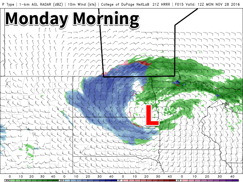
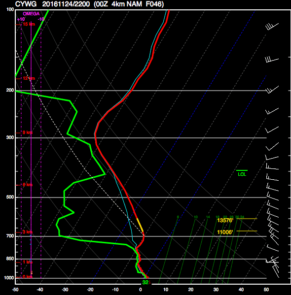
Despite moving onto the back-side of a massive low pressure system with gusty northerly winds, Southern Manitoba won’t be falling into a deep freeze; the cooler temperatures moving in place will instead be cooler but still above typical seasonal values. Alongside the minor cool-down, the region will be dealing with periods of light snow as the low pressure system that brought a mix of rain and snow over the past couple days slowly moves off into Eastern Canada.

Skies will be mainly cloudy over the coming few days, with a slight chance of the odd ray of sunshine on Thursday and a better chance of skies becoming mixed on Friday. Temperatures will be relatively steady through the week as well, with temperatures steady near 0°C today giving way to daytime highs near -2°C on Thursday and Friday. Lows will fall just a few degrees below the highs, with lows near -5°C on Thursday and Friday. On the off chance that some clear patches show up at night, temperatures have the potential to plummet closer to the -9 or -10°C, but those values won’t be seen underneath cloudy skies.

The RDPS forecast shows light snow accumulatiosn across much of Southern Manitoba on Wednesday night through Thursday.

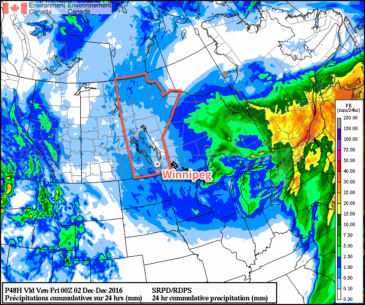
Today will bring periods of light snow to the region, tapering off to scattered flurries tonight and through the next couple days. By Friday, any flurry activity should be relatively isolated. No notable accumulations are expected from the snow over the coming days.

Winds will be out of the north at 20-30 km/h through the day with a few gusts on top of that. The wind will diminish tonight, followed by light winds for Thursday and Friday.

November Looking To Take Top Spot As Warmest on Record

Winnipeg continues it’s incredibly warm winter with non-stop above-normal temperatures.

The average daily high temperature for November 2016 now sits at 7.4°C, beating out the previous record of 7.1°C set in 2009. The average daily low temperature for the month is now at -1.0°C, crushing the previous record of -3.2°C set in 1923. Combine the two, and the average daily mean temperature sits at 3.2°C, beating the 117 year old record of 1.3°C set in 1899 by almost 2°C.

The unprecedented warmth will fade as we head into December, though; all long-range guidance is suggesting a return to seasonal temperatures in the coming week. While colder air does look like it will begin working its way into the Prairies in the coming weeks, so far it appears most of it will remain west of Manitoba, leaving us with a continued stretch of near-seasonal temperatures ahead.

Winnipeg’s seasonal daytime high is currently -6°C while the seasonal overnight low is -15°C.

Colorado Low Looms

Our first significant Colorado Low in some time will bring a variety of precipitation types to southern Manitoba today. Rain, snow, freezing rain, and ice pellets will be possible.

A variety of precipitation types will be possible in southern Manitoba today. The map shows areas of rain (green), snow (blue), freezing rain (purple), and ice pellets (red).

Today

Monday
2°C / 1°C
Mixed precipitation early, then rain

A powerful Colorado Low will bring a mixed-bag of precipitation to southern Manitoba today. Precipitation will likely start out as freezing rain or ice pellets in portions of the Red River Valley and south-eastern Manitoba this morning, before changing to rain later in the morning. Rainfall amounts of 5-10 mm are expected in most areas, with higher amounts possible near the International border. There may be a bit of snow at times, but little accumulation is expected – and any that were to accumulate will be melted by rain later in the day. However, the story will be different in western Manitoba, where snow will be the dominant precipitation mode for the day. Accumulations of 5-10 cm are likely in most areas by tonight. Winds will be gusty out of the north-east at 30 km/h gusting to 50 km/h, bringing some blowing and drifting to open parts of western Manitoba.

Tuesday

Tuesday
1°C / -1°C
Periods of snow

This Colorado Low will take its time exiting our region, affecting us once again on Tuesday. Unfortunately (for some), rain will change to snow on Tuesday in the Red River Valley and south-eastern Manitoba. Accumulations of 4-8 cm are likely in addition to possibly a couple millimetres of rain or mixed precipitation early in the day. Western Manitoba can expect another 5-10 cm on Tuesday, bringing totals up to 10-20 cm. The model graphic shown below, which considers a wide-range of possible solution, shows a very high probability (>80%) of over 10 mm of total precipitation in most of southern Manitoba. Winds will remain gusty out of the north on Tuesday at 30 km/h gusting to 50 km/h.

Most of southern Manitoba stands a very high chance of receiving over 10 mm of precipitation with this system (NAEFS graphic).

Wednesday

Wednesday
-1°C / -4°C
Mainly cloudy with flurries

The Colorado Low will continue to linger on Wednesday, but snowfall rates will decrease. Flurries are expected throughout the day, but accumulations should be small. Winds will remain breezy from the north at 20-30 km/h.

Long Range

It appears that we’ll see generally seasonal to slightly-above seasonal temperatures as we move into early December. However, longer-range models do hint at a very cold arctic air mass being pulling down from the north about one week into the month. This will have to be monitored, as it would be our first significant bought of below-normal temperatures in quite awhile.

Sun Breaks Through For A Mild Weekend

Winnipeg will see a reprieve from the damp, cloudy weather this weekend as the clouds clear out later today and clear to mixed skies move in. Alongside the sun, daytime highs over 5°C above normal will remain in place, continuing the likely record-setting above normal temperature trend seen for the entirety of November so far.

Today will start off cloudy, however throughout the afternoon the clouds should begin to break up as some drier air moves in from the southwest. Without the persistent fog and mist in place, temperatures will have a bit more mobility than they have the past couple days, and Winnipeg should see a daytime high near 3°C. Winds should remain fairly light through the day out of the south to southwest. Expect clear skies giving way to a bit of cloud on Friday night, with temperatures dipping to a low near -3°C.

Saturday morning will start off with some cloud in the area as a warm front pushes through, but then we should see clearing and some sunshine for the afternoon.1 Temperatures should climb to a high near 3°C again with light winds out of the south to southeast. Skies should remain fairly clear on Saturday night with a low near -3°C again.

Sunday will bring increasing cloud to the city through the day as a significant weather system begins organizing south of the border. While skies will be mixed, temperatures will still be pleasant with highs yet again near 3°C. Winds will be out of the southeast at 10-20 km/h. Cloud cover will increase on Sunday night with temperatures dipping down to around 0°C.

Record Warmth

So far this month, Winnipeg has had an average high temperature of 8.1°C. With the forecast temperatures ahead, November will end with an average high temperature near 7.1°C and a mean temperature2 of approximately 2.6°C. The average high temperature will likely end up taking the #1 or #2 spot for warmest Novembers by average high temperature.

RankAverage
Daily High (°C)
Average
Daily Mean (°C)
Average
Daily Low (°C)
17.2 (2016)3.1 (2016)-1.1 (2016)
27.1 (2009)1.3 (1899)-3.2 (1923)
36.4 (1999)1.3 (1923)-3.3 (1899)
45.8 (1899)1.0 (1981)-3.3 (1922)
55.8 (1923)0.9 (2001)-3.5 (1981)
65.7 (2001)0.8 (2009)-3.6 (1917)
75.5 (1981)0.6 (1999)-3.7 (1953)
85.3 (1939)0.5 (1917)-3.9 (2001)
95.2 (1904)0.2 (1922)-4.3 (1918)
104.6 (1917)0.1 (1953)-4.3 (1944)

So far November has had an average overnight low of -0.8°C, with a forecast month-average of -1.0°C. This is a whopping 2.2°C above the previous record of -3.2°C set in 1923. The monthly mean temperature is forecast to end up at about 2.6°C, which crushes the previous record by 1.3°C. To put that in perspective, Winnipeg is forecast to break the previous monthly mean temperature record by the same amount as the spread from the current record to the 10th place entry.

Long Range

The start of next week threatens another winter storm for the region as a Colorado Low moves into Minnesota. Again there’s quite a bit of uncertainty as to how progressive the system will be and whether it will back into the Red River Valley or end up further east and missing the province. The general agreement is that the Red River Valley will be hit by this system, but how much precipitation will fall is a wild card.

The big challenge with this system, should it actually hit the Red River Valley, will be what will actually fall out of the sky. Best indications are that much of what falls may actually be rain rather than snow, but it’s far too early to put too much stock in any particular forecast other than saying that this system, should it hit Winnipeg, will likely bring a wintery mix to the region. We’ll be keeping an eye on it as the system develops!

Winnipeg’s seasonal daytime high is currently -5°C while the seasonal overnight low is -13°C.


  1. Most forecast models show clear skies in the afternoon behind the warm front, however a few outliers want to keep things cloudy. At this point, with a broad southwest to westerly flow expected in the warm sector, I think that skies should manage to clear out, but we’ll keep an eye on things incase pesky cloud manages to stick around. 
  2. The mean temperature is an average of high and low temperatures of each day. 

Mild Conditions Continue

The remainder of the work week will be marked by daytime highs climbing above 0°C, continuing an above-normal temperature trend that has persisted through every single day so far this November.

Today will be damp but mild as stratus cloud bringing drizzle and fog lingers throughout the region. A few isolated flurries may also be thrown into the mix as well, but we’re done with any accumulating snow for now. We should reach a high temperature of +2°C, which will continue to melt the snow that fell yesterday morning across the city. Winds will be light out of the northwest at 10-15 km/h. Expect cloudy skies tonight with a continued chance of drizzle or freezing drizzle alongside fog patches. Tonight’s low should be near -1°C.

Thursday will likely be more of the same with low-level moisture trapped under a slack flow. Temperatures will reach a high near +2°C with light winds. There will be a very slight chance of some patchy drizzle or fog. For Thursday night, skies will remain mostly cloudy until some clearing begins working in late overnight. Temperatures will dip to a low near -2°C.

This forecast sounding for Thursday afternoon in Winnipeg shows a deep layer of saturated air in the lower atomosphere.

Friday will likely bring some sunshine back to the region with more above-normal temperatures on tap as the daytime high climbs to +2 or +3°C. Skies will gradually clear through the day and things should finally start to dry out a bit. Winds will be light out of the south.

Tuesday Snow Breaks Record

While the actual snowfall event that began early in the morning on Tuesday November 22 was unimpressive with just 2-5 cm of fresh snow accumulation across the city, it managed to break a long-standing record: the latest day of first measurable snowfall.

RankDate of First Measurable Snowfall (≥ 0.2cm)Year
1November 222016
2November 211963
3November 201953
4November 191931
5 tie
5 tie
November 18
November 18
1880
2015
7November 171890
8November 161977
9November 151903

Yesterday’s snowfall was the latest in the year Winnipeg has seen its first fall/winter snow in the 144 year old record that dates back to 1872.

Long Range

The weekend looks quite nice with a fair amount of sun and mild temperatures with daytime highs continuing slightly above the freezing mark. Heading into next week, though, it appears another significant winter storm may be brewing. Some long-range models are hinting at the possibility of 10-25 cm over the Red River Valley through the first half of next week, but it’s still too early to really comment on how accurate any of those predictions will be.

That said, the continued significant story is the above-normal temperatures that have been in place the entire month of November and continue to be forecast through to the end of the month. If we do indeed see high temperatures close to what is currently forecast, November will be in the contest for the warmest November on record!

Winnipeg’s seasonal daytime high is currently -4°C while the seasonal overnight low is -13°C.