From Well Above-Normal Temperatures to Well Below

It has been easy to forget that we’re actually well into fall at this point with the gorgeous weather that was in place over the weekend the continued mild temperatures to start the week. A potent reminder is on the way today as significantly cooler weather moves in behind a cold front that pushed through earlier this morning.

Today will start with a few morning showers tapering off, which may be followed by a brief break in the clouds allowing for a little bit of sunshine. Skies will cloud back up quickly, though, and the chance of showers will return for the afternoon. Winds will be fairly gusty out of the south-southwest today, increasing to 30 gusting 50 km/h midday. Temperatures will be significantly cooler than seen in the first half of the week with temperatures gradually falling to around 9°C this evening as Arctic air begins filtering into the region.

Skies will remain cloudy overnight as any remaining showers move out of the region. Temperatures will dip to down to a low around 3°C with the breezy conditions continuing.

Thursday will bring well below-normal temperatures to Winnipeg as mainly cloudy skies with continued gusty southwesterly winds. Not much is expected by way of precipitation and daytime highs will top out near 8°C. Expect an overnight low near 2°C on Thursday night under mainly cloudy skies.

Below-normal temperatures (blue) are expected across the entire Prairies in the wake of a powerful low pressure system that moved through the region in the first half of the week.

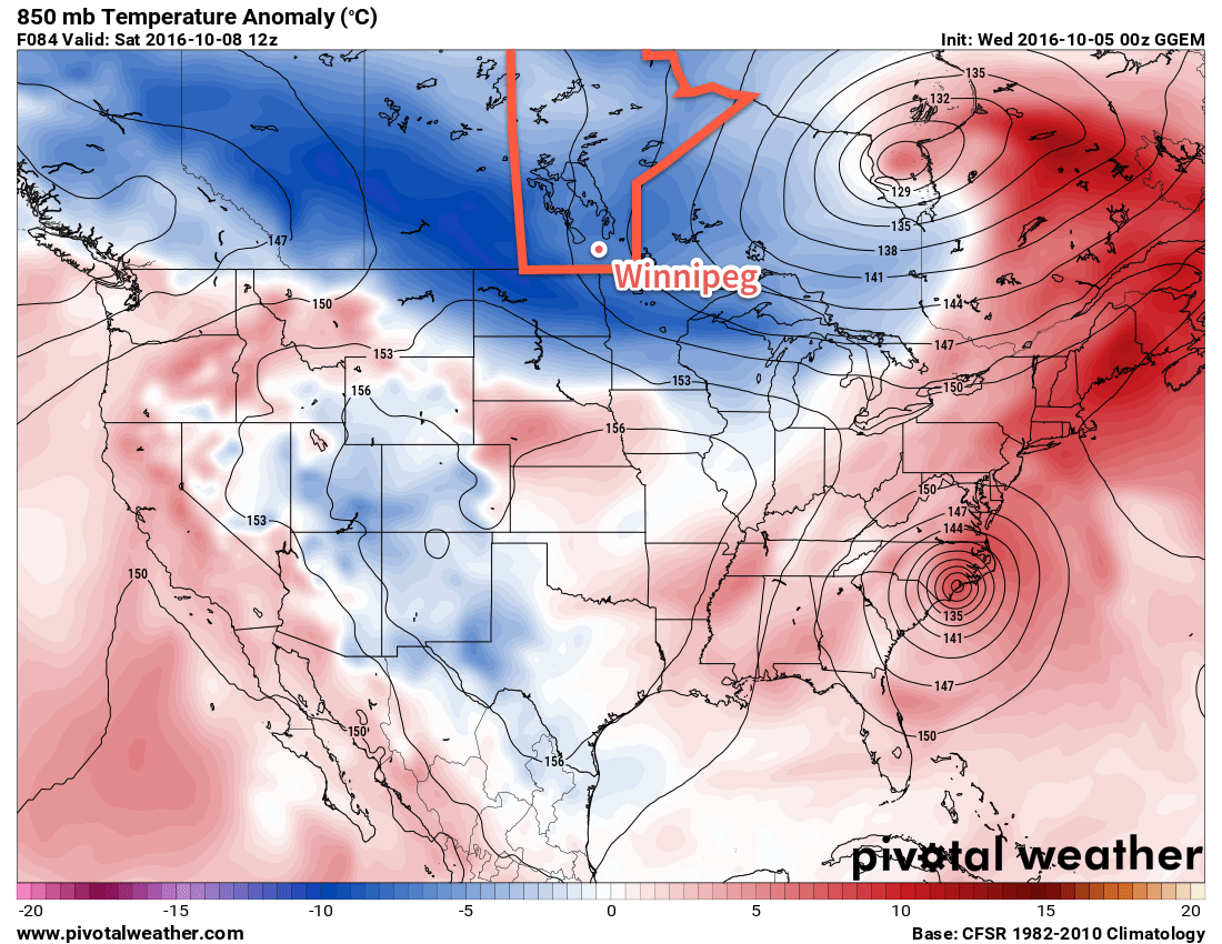
Friday will see the winds shift to northwesterly, continuing to reinforce the cold air as well as firing up the Lake Effect machine. As a result, temperatures will be quite cool with highs near only 8°C again. There will be a fairly good chance of some showers, however that will be greatly enhanced in the lee of Lakes Winnipeg & Manitoba as streamers set up in the cool northwesterly flow. Winds will be moderate as well, increasing to around 30 gusting 50 km/h. Friday night will see temperatures drop to a low near 1-2°C with showers tapering off and some clear patches developing.

Long Range

Temperatures will remain cool with a chance of showers through the weekend and into the beginning of next week as southern Manitoba remains stuck in a northwesterly flow. By the middle of next week, though, we may finally see warmer air begin building across the Prairies, with seasonal to above-seasonal temperatures building in for next weekend.

Winnipeg’s seasonal daytime high is currently 14°C while the seasonal overnight low is 2°C.

One Last Day of Warm Weather

One more day of seasonably warm weather is on the way before conditions cool down. A strong low pressure system will usher in a much cooler air mass by midweek.

A strong southerly flow will be in place over southern Manitoba today

This Week

Today will be another warm, but breezy day in southern Manitoba. A strong low pressure system to the west will develop a stiff southerly flow, allowing for these warm temperatures. Rain is expected to develop over western Manitoba by this evening, but only a chance of showers is expected over the Red River Valley and southeastern Manitoba. Skies will generally be a mix of sun and cloud with temperatures in the low to mid twenties.

Gusty southeast winds will remain over southern Manitoba on Tuesday, but temperatures will cool somewhat. Highs are only expected to reach the upper teens, with mainly cloudy skies. Showers will be likely throughout the day, although large accumulations are not expected.

Significantly cooler weather is on tap for Wednesday as a strong cold front swings through the region. High temperatures are only expected to be in the low teens with gusty southwest winds. Skies will be a mix of sun and cloud with a slight chance of a shower.

Long Range

Cooler weather will stick around for the rest of the week behind the departing low pressure system. As shown above, our warmer-than-normal temperatures that were in place through the weekend and early this week will be replaced by below-normal temperatures behind this low pressure system.

High temperatures will likely be near 10C most days, plus or minus a few degrees. While that seems cool, it is only a few degrees below normal for this time of year.

Above-Normal Warmth Ahead This Weekend

I apologize for the brevity of this post, but with an illness sweeping through the house, I haven’t had too much time to elaborate on the coming days. That said, we have a nice weekend ahead with mild temperatures and plenty of sunshine!

Today will be a pretty nice day with mixed skies and a high near 19°C. Winds will be a bit more prominent out of the south at around 20 km/h with some gusts on top of that this afternoon. Winnipeg will see a thicker band of cloud move through overnight and with it will come a slight chance of some light showers. Temperatures will dip down to about 12°C tonight.

Tomorrow will see morning cloud clearing out as temperatures climb to a high near 21°C. Winds will once again be out of the south at around 15-20 km/h. Expect a low near 13°C.

Sunday will be another nice day with partly cloudy skies and a high near 22°C. Winnipeg will see more cloud move in on Sunday night as a series of disturbances begin moving into the region, bringing several days of unsettled weather to the region to start next week.

Winnipeg’s seasonal daytime high is currently 15°C while the seasonal overnight low is 3°C.

Sunshine Reappears With Pleasant Fall Weather

Those tired of the left-over gloom from the weekend’s weather will be happy to know plenty of sunshine is on the way as a building upper-level ridge brings seasonal temperatures and plenty of sunshine.

The weather for much of this week will be dominated by an upper ridge building across the southern Prairies, bringing pleasant conditions for the end of September with slightly above normal daytime highs. The next few days will bring plenty of sunshine with just a few clouds to partly cloudy skies expected.

Temperatures will gradually climb to around 5-6°C above seasonal by the end of the week; daytime highs near 17°C today in Winnipeg will increase to near 20°C for Thursday and Friday.

The red colours on this map of 850mb temperature anomalies shows the warmer than normal weather expected over Southern Manitoba this week.

Fortunately, it doesn’t appear the wind will pose too much of an issue either. Winds will be calm today, and then increase to around 10-20 km/h out of the south for Thursday and 15-25 km/h out of the south on Friday.

Long Range

The weekend forecast gets a little more complicated, but overall it’s looking like the weather should stay dry until the start of next week.

As the weekend progresses, a long-wave upper trough will dig over the western half of the continent. We should remain relatively unaffected by this with mild weather continuing through the weekend. Late Sunday into Monday, a shortwave will eject northeastwards out of the trough, moving into Southern Manitoba, and will bring some rain to the region. The timing of this is uncertain at the moment, but it looks likely that it won’t move into the province until late Sunday at the earliest.

So until that moves in, the weather should remain quite nice with mild temperatures and relatively light winds.

Winnipeg’s seasonal daytime high is currently 15°C while the seasonal overnight low is 4°C.