In the wake of yesterday’s cold front that brought some wild weather to Manitoba yesterday afternoon & evening, conditions will be significantly more benign as a ridge of high pressure moves into the Red River Valley and brings dry weather with seasonal temperatures.
There is not too much to say for today’s forecast post. Mainly sunny skies will dominate the region today as a ridge of high pressure builds in from the northwest behind yesterday’s cold from that moved across the region.
A ridge of high pressure aligned through Saskatchewan into southwestern Manitoba will bring benign weather to the region.
Winds will be breezy at 20-30 km/h first thing this morning, but will fairly quickly taper off into the 15-20 km/h range. Winds will remain light through Wednesday.
Temperatures will be fairly steady with daytime highs around 23-24°C all 3 days. Overnight lows will be cool, in the 9-11°C range on Monday night and Tuesday night, however slightly milder air begins working in on Wednesday night, bumping the overnight low up towards the mid-teens.
No precipitation is expected. Skies will be mainly sunny both today & Tuesday, however a little more cloud is expected on Wednesday, with sunny skies likely giving way to more mixed conditions in the afternoon.
Long Range
The second half of the week looks to bring warmer conditions back into the region with daytime highs climbing back towards the 27 or 28°C mark with variable cloudiness. Friday evening into Saturday looks to be the first chance of any more precipitation, with thunderstorms possible. At this point, it looks most likely that they would occur overnight into Saturday morning.
So a very pleasant week ahead with little precipitation; it’s nice to finally give some good news!
Winnipeg’s seasonal daytime high is currently 22°C while the seasonal overnight low is 9°C.
Seasonal to slightly above-seasonal temperatures are on the way to Winnipeg this weekend alongside a couple chances for rain as a couple low pressure systems move through the province.
Today will be a relatively pleasant day in Winnipeg as sunny skies give way to some afternoon cloudiness as temperatures climb to around 25°C. Winds will be out of there south at 15-20 km/h. Expect a low near 13°C tonight with increasing cloudiness near morning.
A low pressure system will move but on Saturday, bringing fairly cloudy conditions and a chance of showers. Temperatures will reach a high near 23°C with winds out of the south at 20 km/h. Depending on the strength of this system, a few thundershowers may be possible, but no severe weather is expected at this time.
A low pressure system will bring warmer weather to Winnipeg on Sunday
Sunday will be a much warmer day as a low pressure system tracking across the central Prairies draws air up from the south. Daytime highs will reach around 28°C work winds continuing out of the south at around 20-30 km/h. Skies will be partly cloudy, but the cloud cover will thicken up heading into the evening hours as a trough extending southwards from the low pressure system approaches. This feature will bring a chance for showers or thunderstorms Sunday evening into the overnight. Temperatures will remain miles on Sunday night with the temperature hovering near 20°C until late overnight when a cold front moves through and stops the temperature towards the mid-teens.
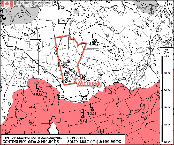
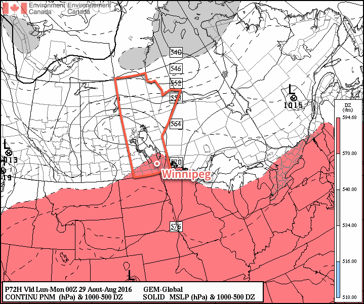
Update: Severe Thunderstorms Possible on Sunday
The threat for severe thunderstorms will return to Winnipeg, the Red River Valley, the Interlake and points eastwards as a warm and relatively humid air mass building in over the region clashes with a cold front pushing eastwards across the province later today.
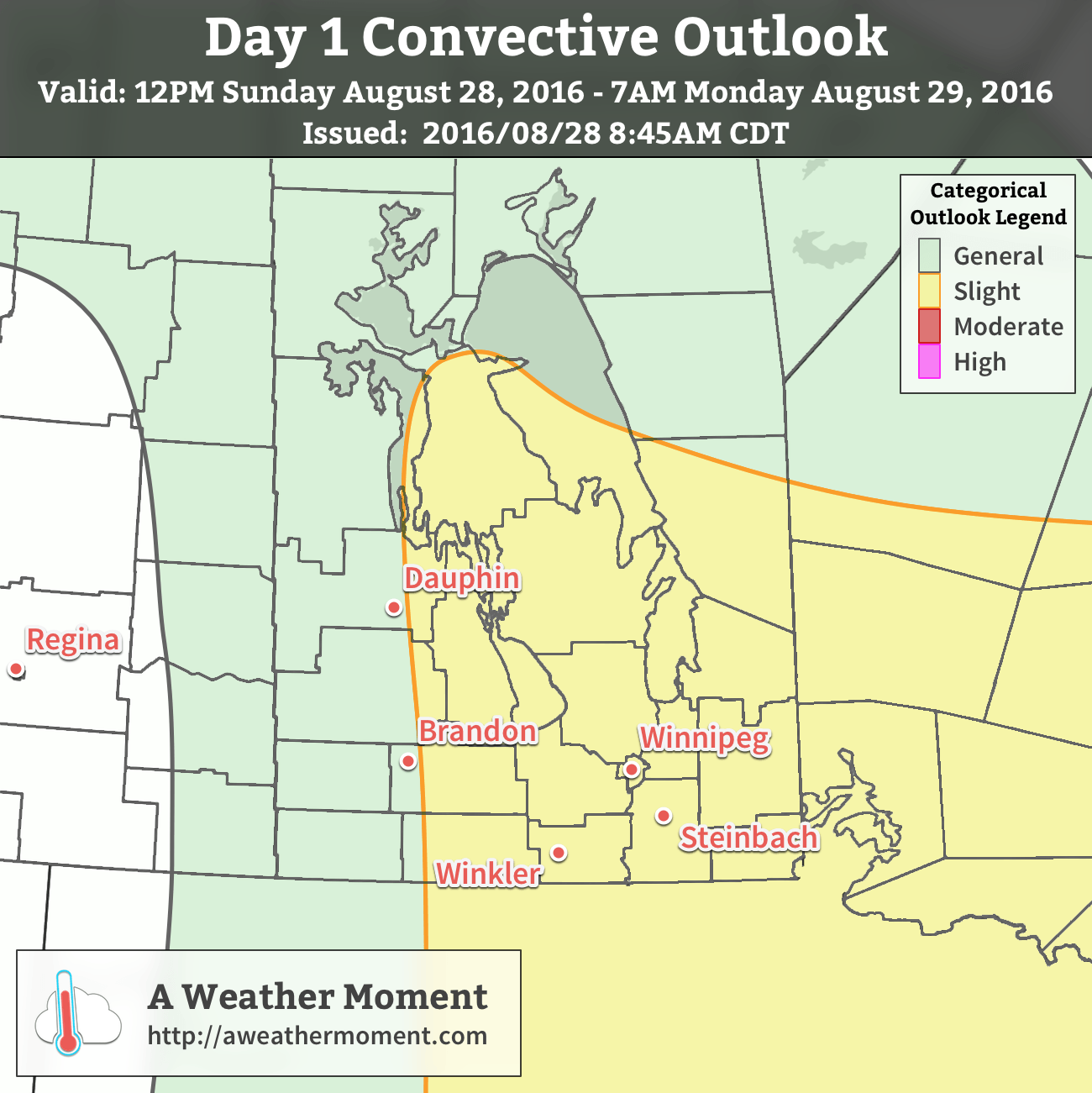
AWM Day 1 Convective Outlook – August 28, 2016
Today’s thunderstorms are expected to develop along a cold front pushing into the Interlake & Red River Valley late this afternoon, likely around 6-7 PM. These thunderstorms will likely grow fairly quickly a complex of severe thunderstorms that will move east-southeastwards with new storms developing as they build southwards down the cold front. These thunderstorms will be capable of all modes of severe weather: torrential downpours causing flash flooding, large & damaging hail, wind gusts exceeding 100 km/h, and tornadoes. It will be prudent to monitor Environment Canada for any watches or warnings that may be issued later today.
MoistureInstability: Ample instability is expected to develop ahead of the cold front with MLCAPE values approaching 4000 J/kg. This will be capped by roughly 30-50J, but is expected to erode through the mid-to-late afternoon. The cap brings the only uncertainty to today: will it break and produce surface based thunderstorms with a tornado threat, or will it prevail and shift the convection to an elevated mode that will favour large hail and strong winds?
Shear: With a potent upper low entering northern Manitoba and dynamic cold front moving through the region, 40-55 *kt* of bulk shear produced with looping hodographs.
Trigger: The cold front combined with forcing from the escarpment should be enough to initiate convection today.
The thunderstorms will progress across the region through the overnight hours.
Winnipeg’s seasonal daytime high is currently 23°C while the seasonal overnight low is 10°C.
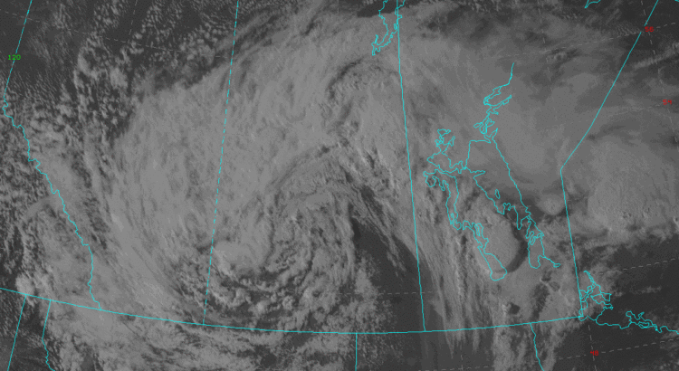
Significantly cooler weather will move into the Winnipeg area as a major low pressure system that brought a bevy of severe thunderstorms to Western & Interlake Manitoba yesterday pushes eastwards through over the coming days.
Today’s weather will be dominated by a large upper-level low moving across Southern Manitoba. This morning will start off mainly sunny through the Red River Valley as the system’s dry slot moves through, but as the day progresses cloud will build into the region from the northwest. Along with the cloud will come widespread shower activity that will persist well into the evening hours.
Temperatures will be much cooler than yesterday as a westerly wind of 20-30km/h that strengthens to 30 gusting 50km/h in the evening ushers in cooler air from the north. Temperatures will reach a high near 22 or 23°C today and head to a low near 12°C tonight. The shower activity across the Red River Valley should taper off late overnight.
Thursday will be another cool day with mixed skies and a daytime high near 20°C. There will be a slight chance of a light isolated shower as the remaining instability is flushed out of the region, but nothing significant is expected. Temperatures will be cool on Thursday night as they dip to around 9°C under mainly clear skies.
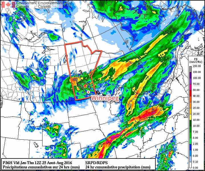
The RDPS is forecasting a total of 2-5mm of rain through the RRV by Thursday morning.Friday will begin to see warmer air return as a system slumping towards Manitoba from the northwest drags some warmer air back towards the region with it. Winds will be breezy out of the south to southwest at around 20-30 km/h as temperatures climb into the mid-20’s. Skies will be partly cloudy, with thicker cloud cover building in through the evening. Expect a low overnight near 13°C.
Looking Ahead to The Weekend
The coming weekend is looking fairly pleasant with plenty of sunshine, warm temperatures in the mid- to upper-20’s and very chances of rain as weather disturbances track to our north across Central Manitoba and to our south through the Dakotas.
Winnipeg’s seasonal daytime high is currently 24°C while the seasonal overnight low is 10°C.
The heat will return early this week as temperatures climb up to the thirty degree mark. This warm and humid air mass will also bring another risk of thunderstorms to southern Manitoba on Tuesday.
Hot weather is in store for southern Manitoba early this week
This Week
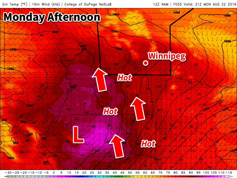
Today will be a hot one in southern Manitoba. Temperatures are expected to climb into the low thirties in most areas. The humidity will begin to climb as well, with dewpoints reaching the upper teens in most areas by late Monday – although locally higher dewpoints will be possible. Despite these hot and humid conditions it doesn’t appear that we’ll see any storms today. The atmosphere is expected to be capped, preventing thunderstorms from developing. There is a slight risk of storms overnight, but conditions don’t look particularly good for widespread development.
Tuesday will be the more interesting day storm-wise, as humidity increases further. A low pressure system is expected to sit over southern Manitoba by midday Tuesday, maintaining a south to southeast surface flow over the Red River Valley and southeastern Manitoba. Instability will be high with the hot and humid conditions, while wind shear is also strong because of the approach of a strong upper-level trough. These conditions should be favourable for the development of severe thunderstorms. High temperatures should end up near 30C with the humidex in the upper thirties. Skies will be mainly sunny before storms begin to develop.
A strong cold front is expected to slice through southern Manitoba on Wednesday morning. This front will drop temperatures down to near the 20C mark. The front will also take advantage of the lingering humidity in the atmosphere to produce shower activity over most of southern Manitoba. Following the frontal passage, it will become quite gusty as well, with northerly winds of 40 km/h gusting to 60 km/h.
Long Range
It appears that temperatures will begin to rebound later this week following the passage of that cold front on Wednesday. Temperatures approaching the 30C mark may be possible again by the weekend – although models are still unclear as to how long and intense this next burst of heat will be.