Cool Weekend Offers A Break From Thunderstorms

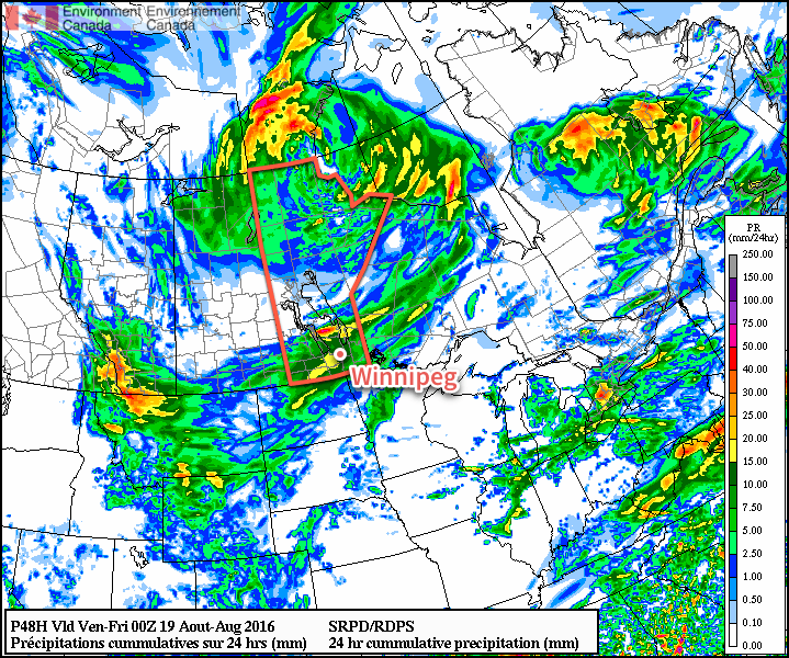
The weather is taking an abrupt turn today as significantly cooler air moves into Southern Manitoba behind the low pressure system that brought numerous thunderstorms to Winnipeg & area on Wednesday night.

Today will see unseasonably cool temperatures as a high pressure system moving into Manitoba draws air from the Arctic and ushers it southwards into the province. The cool air, coupled with the August sun, will result in plenty of cloud and some scattered showers through the afternoon. With a northwesterly wind of 20-30 km/h, temperatures will climb to a high near 20°C.

Skies will remain fairly cloudy tonight as cool air continues to push southwards. For areas in the western Red River Valley, it appears that the Arctic air will trigger some lake-effect showers that will move southwards off of Lake Manitoba. There’s a lesser chance that similar showers will develop off of the south basin of Lake Winnipeg as well. Winnipeg will end up tucked between the two and should remain dry for much of the night. Expect overnight lows to dip down to around 8 or 9°C.

The bright green swath over the western RRV shows the expected lake-effect showers on Friday night.

Saturday will be a drier day with the cool weather continuing. Daytime highs will climb to around the 19°C mark under mixed skies. Skies will clear out for Saturday night for another cool one with overnight lows near 8°C.

Sunday will return to closer to seasonal temperatures with highs near 24°C under mainly sunny skies. There will be a bit of cloud moving through later in the day as warmer air begins moving into the region, but no precipitation is expected in the Red River Valley with it at this point.

So, while it will be cooler, we’ll get a short break from the severe weather threat that has been so frequent the past few weeks across Southern Manitoba. Next week looks like a bit of a mixed bag with dry, warm weather through the first half of the week being replaced by cooler, more unsettled weather in the second half.

Winnipeg’s seasonal daytime high is currently 24°C while the seasonal overnight low is 11°C.

The Summer of Storms Continues

Whether you’re in the middle of a home renovation that involves taking off part of your roof as I am[1], trying to harvest fields, or just trying to string together a few dry days for a camping trip, this summer continues to challenge as the threat for thunderstorms continues across the Red River Valley.

Today will be a hot one across southern Manitoba as a light southerly wind taps into a warmer air mass to our south, drawing daytime highs up to around the 30°C mark in Winnipeg. Skies will be fairly sunny until late in the day when cloud cover begins thickening up from the west.

Estimated precipitation totals from the RDPS for Wednesday night through Thursday.

A cold front sweeping into Manitoba through the evening and overnight will once again spread showers and thunderstorms into Manitoba. There will be a slight risk of severe thunderstorms in the late afternoon and evening hours to the north and west of the Red River Valley. This severe thunderstorm threat will shift into the Red River Valley late in the evening & into the overnight period. These thunderstorms will pose a primary threat of large hail and damaging winds.

The unsettled activity will persist into Thursday morning with more showers and thunderstorms possible as the upper-level support for this disturbance rolls through. Winds will pick up out of the northwest to about 20 km/h as skies begin to clear for the afternoon. Temperatures will be a just slightly cooler with a high near 27°C, but the overnight low on Thursday night will be much cooler at around 13°C.

Friday will continue the cooling trend in temperatures as another cold front pushes through, limiting daytime highs to the low 20’s. Mixed skies will be in place alongside a slight chance of some afternoon showers and gusty north to northwesterly winds of 20-30 km/h.

Winnipeg’s seasonal daytime high is currently 25°C while the seasonal overnight low is 12°C.


  1. Anyone? Just me?  ↩

Warm With A Risk of Thunderstorms

This week will be a warm one, with temperatures frequently reaching the upper twenties. This heat will be accompanied by some humidity, which will prompt a renewed risk of thunderstorms.

A warm front will be located in southern Manitoba today

This Week

Today will be a hot one in southern Manitoba. Temperatures will be in the upper twenties to near 30C, with increasing humidity making it feel more like the mid thirties. Winds will generally be light, with the direction varying between easterly and southerly depending on your location. The heat and humidity today will prompt a risk of thunderstorms. Some storms may be marginally severe, as moderate instability but weak wind shear characterizes the environment. Any severe storms could potentially produce hail around nickel size and wind gusts to 90 km/h – although the odd storm may slightly exceed those values. Storm coverage is not expected to be very widespread, so many people may not see any activity.

A weak cold front will pass through early Tuesday, cooling us down a little bit. High temperatures on Tuesday will generally be in the mid twenties, with some lingering humidity making it feel closer to 30. A risk of thunderstorms will once again be present due to that lingering humidity, but any storms that develop should be non-severe. Winds will be northerly at around 20 km/h.

Slightly warmer conditions are expected again for Wednesday as temperatures climb into the upper twenties with light southerly winds. Skies are expected to be mainly sunny, making for quite a nice day!

Long Range

The long range forecast shows a stronger cold front passing through southern Manitoba later this week, likely on Thursday or Friday. Depending on the timing of this front, it may pose another risk of thunderstorms. Following the frontal passage we’ll see somewhat cooler conditions, likely persisting into the weekend.

Cool End To The Week

Cooler weather and scattered showers will settle into the Red River Valley today behind the low pressure system that brought multiple rounds of thunderstorm activity to Southern Manitoba over the past several days. The cool weather will give way to more seasonal warmth by the end of the weekend, but with the return of warmer weather will come another chance for thunderstorms in the first half of next week.

The weather in Winnipeg over the coming two days will be created by an upper-level low pressure system stalled out over east-central Manitoba. Both today and tomorrow will see fairly cloudy skies, likely mixed to mainly cloudy, alongside the chance for scattered showers. Today will present a better chance for showers than tomorrow, but even then the activity will likely be fairly light and scattered. Winds will be out of the west to northwest at around 20-30 km/h during the days and lighter at night. Daytime highs will be below-seasonal at just 21 or 22°C, however the overnight lows will be right on the mark for this time of year at 12 or 13°C.

Scattered showers are expected over southern Manitoba over the next two days.
The cloud should clear out on Saturday night as the upper low finally trundles out of the region and a ridge of high pressure builds in.

Sunday will be a comparatively pleasant day with mainly sunny skies, although the beginning and end of the day may be bookended by some clouds. Daytime highs in Winnipeg & the Red River Valley will be fairly warm at 26 or 27°C. With warmer air in place, the overnight low on Sunday night will also be milder at around 14 or 15°C.

Long Range

Early next week is looking mild, but the weather trend of 2016 continues with another chance for showers and thunderstorms returning sometime late Monday into Tuesday. At this point, it appears that this will appear as a round of thunderstorms on Monday night, but it’s still quite early and the timing of the system could easily change.

The long-term pattern continues to show an unsettled pattern with a couple days of showers and instability followed by a few days of drier weather. There are hints of attempts to produce more prolonged periods of dry weather in 1-3 weeks from now, but models seem to be struggling to establish the ridging required. So at this point, it looks like more of the same for the coming weeks, which is not likely the news that many farmers wish to hear heading towards harvest.

Winnipeg’s seasonal daytime high is currently 25°C while the seasonal overnight low is 12°C.