Small Disturbance Today; Significant Colorado Low This Weekend

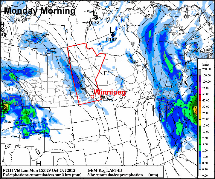
There will be a very slight chance of showers today as a low pushes across the Interlake region, however the bigger news will be this weekend, when a powerful Colorado Low ushers in winter over Southern Manitoba.

The rough track of the upcoming Colorado Low

A satellite image showing the current position and estimated track of the Colorado Low that will impact Southern Manitoba this weekend.

A low pressure system track through the Interlake today will bring 10-15cm of snow through Central Manitoba, north of the track of the low. Through southern Manitoba, there will just be a slight chance of a shower through the afternoon and evening as most areas see a mainly cloudy day with a high near 3 or 4°C. There’s a slight chance to see some sun across many areas this morning, however the likelihood of fog development in any clear areas may mask the chance for sunshine.

Thursday will bring some sunshine and a windy morning, with winds gusting out of the N/NE to 30 or 40km/h behind the system, but should lighten into the afternoon. Temperatures will be cooler than late, with highs only around -1 or 0°C.

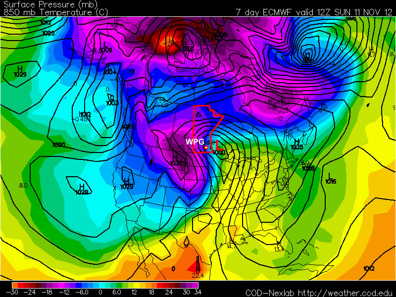
By Friday, we’ll begin to feel the impact of the Colorado Low. Winds will begin to pick up out of the northeast as snow begins pushing into SW Manitoba. Snow will make it’s way into the Red River Valley overnight, with steadier snow developing Saturday morning. Disagreement still exists amongst the model runs as to where the heaviest snowfall will be, however the NAEFS (North American Ensemble Forecast System) has been startling consistent over the past few days with painting the heaviest snowfall right over Winnipeg.

Probability of > 10cm of Snowfall

Probability of ≥ 10cm of snowfall from the NAEFS, valid from 12Z November 10th to 00Z November 11th (a 12hr. accumulation).

The NAEFS is showing significant confidence in areas in Southwest Manitoba (Melita, Pilot Mound, Virden and Brandon) regions seeing more than 10cm of snow, with a decent likelihood of people west of the Red River seeing ≥ 10cm as well. North of the Trans-Canada highway, it looks like from Portage to Winnipeg has a sizeable chance of seeing greater accumulations, as well as into the Southern Interlake.

Snow will taper off on Sunday, however significant accumulations will likely have developed in it’s wake. Current indications are that the SE corner of the Red River Valley will see the least snow, and accumulations will increase as you head west and north. In addition to the snow, gusty winds to 50 or 60km/h will push into the Red River Valley as well, producing widespread reductions in visibility due to falling and blowing snow. System-total precipitation looks to be 15-25mm, which when taking into account the expected SLR (snow-to-liquid ratio) of around 10:1, would result in a total of 15-25cm of snow. General estimates for accumulated snowfall by the end of the weekend for a few select sites are:

  • Winnipeg: 15-20cm
  • Steinbach: 10-20cm
  • Morden/Winkler: 15-25cm
  • Portage la Prairie: 15-25cm
  • Brandon: 10-20cm
  • Pilot Mound: 15-25cm
  • Sprague: 5-15cm
  • Victoria Beach: 10-20cm
  • Gimli: 10-15cm

We’ll have more updates on the track of this system as the week progresses. Monitor EC’s Weather Office site for forecasts and any watches or special weather statements as the week progresses. Although the exact timing and intensity of this system may be difficult to pin down, it’s a safe bet to say that driving conditions will likely be extremely poor with ice-covered roads and low visibilities in blowing snow. Conditions in North Dakota will also be quite poor as well this weekend. If you have plans to travel by car/truck this weekend, be sure that you’re prepared for the hazardous weather that will be present. Always carry a winter survival kit in your vehicle if you must travel during winter storms.

Winter Looms

The weather for most of this week will be fairly calm and uneventful, but current forecasts show the potential for a major winter storm next weekend.

The ECMWF model is predicting that a major winter storm will impact Southern Manitoba next weekend

The ECMWF model is predicting that a major winter storm will impact Southern Manitoba next weekend

Monday’s weather will be fairly seasonal, with high temperatures just above zero. There may be some light rain during the afternoon and evening hours as a trough of low pressure swings through, though nothing particularly significant. Tuesday will see little change from Monday, with temperatures once again in the low single digits. Perhaps the biggest difference between these two days will be the wind direction, with the wind being north-westerly on Tuesday, as opposed to southerly on Monday. Wednesday will once again be a seasonal day, with temperatures around or slightly above zero.

The main attention this week will be focused on the potential for a major weather system next weekend. Weather models are currently showing a significant Colorado Low system impacting Southern Manitoba next weekend, with the potential for heavy snow and strong winds. At this point it is impossible to predict exactly how this system will affect us, other than to say it could cause significant disruptions. Just as it is impossible to know the exact impacts of this storm this far in the future, it is also not possible to know for sure if this storm will hit us at all. Based on the latest guidance, there does appear to be a reasonable chance of it impacting Southern Manitoba in some way, but we won’t be sure for a few more days. In the meantime, we’ve got some interesting weather to talk about!

A Snowy Start to the Weekend

A compact shortwave moving across southwestern Manitoba will bring snowfall to the Red River Valley and areas west today and tonight.

500mb vertical velocities for 18Z today

500mb vertical velocities for 18Z today. This image shows an area of lift (air moving upwards) over the Red River Valley by noon today. This will contribute to the generation of snowfall over the area.

A broad area of moderate lift ahead of a shortwave is producing an area of snow that will push eastwards into the Red River Valley by late morning, although the exact eastward extent of the snowfall will be quite tricky to nail down as the lift creating the snow will [somewhere near the Red River Valley] slow down and pivot to the south as the shortwave dives into the Dakotas.

Before we get to snowfall accumulations, we’ll quickly cover our temperatures for the weekend. Because no surface fronts are associated with the weather we’ll get (all of the forcing is aloft), temperatures through the Red River Valley will not vary too much from yesterday. Daytime highs through the weekend will vary from about 0°C to 2°C. Overnight lows through the weekend will generally sit around -4°C, plus or minus just a couple degrees.

Onto the snowfall! Snow has spread into SW Manitoba overnight, bringing light to moderate snow that will last another 12-18 hours. Snow will begin to push into the RRV by late morning, however the eastern extent is difficult to pin down with amounts likely diminishing somewhere over the eastern Red River Valley into the Whiteshell. One of the biggest challenges to this system will be the SLR: snow-to-liquid ratio. This is a measure of how much snow a certain amount of water will generate. Typically on the Prairies, SLRs tend to be in the 10:1 to 15:1 range; if you had a 10:1 SLR, that would mean that 1mm of liquid water would produce 1cm of snow. If it were 15:1, then 1mm of liquid water would produce 1.5cm of snow.

Over southwestern Manitoba models are predicting generally 10mm of precipitation, over the Parkland regions of Manitoba about 5-10mm is expected to fall and over the Red River Valley, 2-5mm is forecast. Best guidance is showing SLR values of around 11:1, which would result in the following snowfalls:

  • Southwestern Manitoba: 11cm
  • Parkland Manitoba: 6-11cm
  • The Red River Valley: 2-6cm

The greatest uncertainty with this system is how far eastwards the snow will push, but in general, this will be the first accumulating snowfall in quite a while over Southern Manitoba. Winds will be light throughout this event, which will prevent blowing snow from being a problem, but drivers should be prepared for the potential of poor driving conditions through the Red River Valley and areas across the west and southwest portions of the province tonight through tomorrow morning.

Some lingering light snow will be out and about through the rest of the weekend, but no significant snowfall is expected.

Small Warm-Up

We’ll see warmer conditions for the beginning of this week. Temperatures may even climb above normal!

Shower activity on Monday

Light rain over parts of Manitoba on Monday

While Sandy hits the eastern coast of the United States hard during the early part of this week, the weather in Southern Manitoba will be very quiet. Temperatures on Monday will be in the mid to upper single digits in Southern Manitoba, which is near to slightly above the average daytime high of 5C. In terms of precipitation, a passing upper-level disturbance on Monday will generate cloud and some light showers in Southern and Central Manitoba. The most favoured area for shower activity is Western Manitoba, though other parts of Southern Manitoba stand a small chance of seeing a light rain shower. On Tuesday a passing trough of low pressure may once again generate a few showers, though they will be very light and scattered in nature. Tuesday’s high temperatures will be very similar to Monday’s, once again being in the mid to upper single digits.

Halloween Wednesday will be a chilly day, as cool north-westerly winds flow out of a surface ridge over Saskatchewan. Temperatures during the daytime will only be slightly above zero, but will drop near to or slightly below zero by the trick or treating hours. No precipitation is expected on Wednesday.

Conditions through late week will remain fairly seasonable, with daytime highs hovering near to or slightly below 5C. No major shifts in our weather are expected in the foreseeable future. In general, seasonable to slightly below seasonal values are expected over the next while.