Another Blast of Heat

Some more hot weather is in store this week as we close out August. We might even see our hottest day of the summer!

Temperatures in the mid to upper thirties are forecast for parts of Southern Manitoba on Wednesday

The WRF/NAM model is predicting temperatures in the mid to upper thirties in the Red River Valley on Wednesday

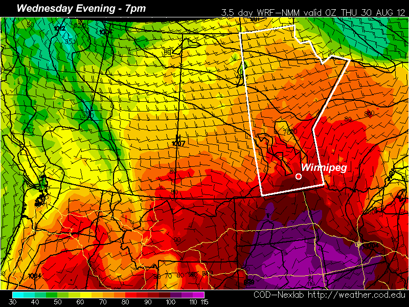
Yet another ridge of high pressure will build over the Prairie provinces for this week, bringing more hot weather. Monday will be a nice day, with light winds and high temperatures in the mid to upper twenties in Southern Manitoba. Skies should remain mainly sunny as high pressure suppresses convective cloud cover. By Tuesday temperatures will climb up around the 30C mark, but humidity levels should remain low keeping conditions at least somewhat bearable. Wednesday could potentially be the warmest day so far this summer in many parts of Southern Manitoba. Current models give the following high temperature predictions (for Winnipeg):

  • NAM: 36C
  • ECMWF: 35C (estimated based on 850mb temps)
  • GFS: 32C
  • GEM: 30C

Based on recent model performances, the NAM should be the favoured solution at this point. Given that low humidity is expected on Wednesday, there certainly is the potential for temperatures to reach the mid and upper thirties in Southern Manitoba. The two main factors that will determine how hot it gets are:

  1. How much warm air manages to flow in at the low-levels on Wednesday
  2. Whether or not a moderate-strong low pressure system forms to our west, causing winds to stay southerly or south-easterly on Wednesday

If 850mb temperatures manage to sneak up into the mid twenties over Southern Manitoba on Wednesday and the wind veers to south-westerly or westerly, then expect high temperatures in the mid to upper thirties in most areas. However, if the wind stays more south-easterly on Wednesday with cooler 850mb temperatures, then highs will likely stay stuck around the 30-33C mark. Of course all the above points assume that we will see sunny skies on Wednesday. At this point there doesn’t appear to be anything which would indicate that we will see extensive cloud cover, but that is always a wildcard to consider.

A cold front is expected to pass through at some point on Wednesday night or Thursday, cooling temperatures back down into the twenties for Thursday and Friday.

Stormy Night Ahead; Cooler Weekend

Another 30°C+ day will give way to stormier weather tonight as a cold front pushes across Southern Manitoba. We’ll see a slightly cooler weekend than the weather of late as we remain in the cooler air behind this system.

Precipitable Water for Friday Night

Precipitable water from the GEM-REG as the cold front pushes into the RRV tonight. Elevated values of 40-50mm through the RRV indicate the potential for stronger storms with locally heavy rainfall.

We’ll see temperatures climb into the low 30’s across Southern Manitoba again today as we remain under the influence of a pool of warm air entrenched over the Eastern Prairies. After some of this morning’s debris cloud from last night’s nocturnal convection clears out, here in Winnipeg we’ll climb to a high near 31 or 32°C, while areas to our south could reach as high as 33°C today.

Things will change promptly this evening as a cold front pushes across the province. Showers and thunderstorms will develop along the front in the early to mid-evening and continue to grow in coverage as the night progresses. This line of showers and thunderstorms will move through the Red River Valley overnight, bringing 5-15mm of rain to the region, the potential for some areas to see a bit over 1” total accumulation, and hopefully a good light show. These storms are not expected to be severe, and could potentially be one of the last night-time light shows we’ll get in 2012.

Tomorrow we’ll see a daytime high only around 24°C with a southwesterly wind at 20-30km/h. Sunday will reach about 25°C with lighter winds. Skies should be mostly sunny both days, with just an occasional cloudy patch here and there.

Temperatures are expected to climb back towards the 30°C mark through the first half of next week.

Hot, Sunny Weather This Week

Winnipeg and the Red River Valley will be basking in hot, sunny weather this week as an upper ridge pushes it’s way across the Prairies. We’ll see a chance of thunderstorms on Thursday evening as a disturbance rolls through the RRV, but quickly return to sunny, warmer-than-seasonal weather.

850mb Temperatures this evening from the GEM-REG

850mb temperatures for this evening from the GEM-REG model. Warm air is building into S. MB bringing daytime highs near 30°C.

A broad southerly flow ahead of an incoming upper ridge has pumped temperatures up over Southern Manitoba back to the 30°C mark. 850mb temperatures will climb up to nearly 20°C today, which will allow our daytime high to soar towards 31 or 32°C. The warm air in place over us will also result in a dramatically warmer overnight low; while the past couple nights have dropped into the low-to-mid teens, we’ll see the mercury barely dip below 20°C tonight.

The normal daytime high for late August in Winnipeg is about 24°C. The normal overnight low is about 11°C.

Thursday will be another warm day, however an incoming shortwave will slide along the International Border through the day, bringing some showers on Thursday morning to SW MB and the risk of an isolated thunderstorm to the Red River Valley, from the Winnipeg area all the way south to Fargo. If storms develop, they’ll develop late in the afternoon along a weak trough line that’s expected to develop in response to the upper feature. Ultimately, I think that most of the storms will remain south of the border with only a very slight chance of anything popping up on the Manitoba side of the RRV. Scott’s Southern Manitoba Mesonet will be a great way to track the trough through the afternoon to see if the threat for storms has passed by you. Despite the heat that will be present with daytime highs near 30°C, dynamics look fairly weak and I do not expect that any storms that may develop will become severe.

We’ll see temperatures dip to around 15°C on Thursday night. On Friday, we’ll see plenty of sun and daytime highs continuing to be near 30°C.

For the weekend, it looks like a cold front will sweep into the province on Saturday, bringing with it some showers and cooler weather; daytime highs look to be in the low-20’s for Saturday. Temperatures look to rebound quickly on Sunday, though, with highs pushing back to the high-20’s. So despite our rather cool start to the month, we may yet come out with our 14th consecutive month of above-normal temperatures in Winnipeg. 5 days out of the next 7 are forecast to have daytime highs at least 3°C above normal, and overnight lows look to remain above normal as well.

Hot Weather Returns

After a period of cool weather over the last while, warmer conditions are set to return.

30C temperatures are expected on Tuesday in Southern Manitoba

The NAM model is predicting that Southern Manitoba will see temperatures of 30C or higher on Tuesday

A ridge of high pressure will build over the Prairies this week, allowing for some of the warmest weather we’ve seen this August to develop. Monday will be a pleasant day, with high temperatures in the mid to upper twenties. By Tuesday many areas should see their first 30C readings this month, as warmer air pushes in from the west.

The ridge will begin to break down on Wednesday and Thursday as a series of impulses move in from the Pacific. These impulses with have one or more low pressure systems associated with them, causing some unsettled weather to start developing over the Prairies later this week. It looks like an easterly flow will develop over Southern Manitoba on Wednesday out ahead of an approaching low. Depending on how the frontal features setup on Wednesday we may or may not see another 30C day. At this point it looks most likely that Wednesday will have temperatures in the upper twenties, rather than thirty, but there is the potential for warmer weather. On Thursday we may see our first risk of thunderstorms in a while as a strong southerly flow draws up more humid air from the south ahead of an approaching low pressure system.

As we move toward the weekend weather models show a series of fairly strong low pressure systems moving through our region. Should these systems develop more or less as predicted it would likely mean a rainy and cool last weekend of August.