Calmer Weather On Tap (for Manitoba)

After a wild week of weather that featured heavy snowfall across many parts of Southern Manitoba conditions will begin to calm down. However, the same can’t be said for areas just to our south.

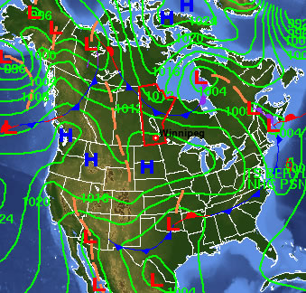
Surface Map Showing the Colorado Low

Surface map showing the forecast track of the Colorado Low

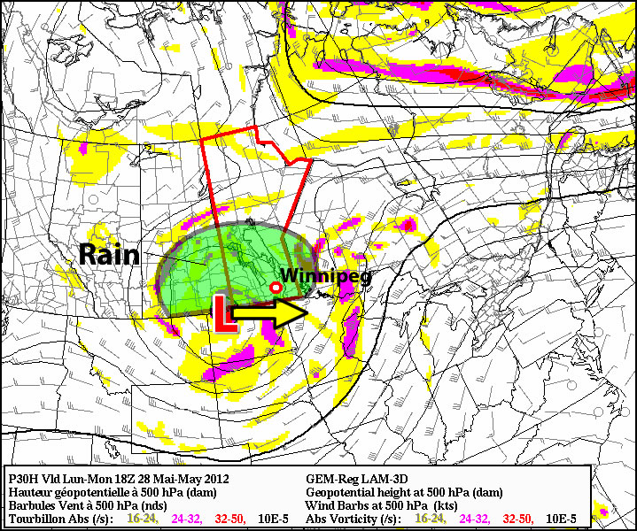
A major winter storm will impact portions of the North-Central United States just south of Manitoba. Areas such as Fargo, North Dakota, Minneapolis, Minnesota, and Aberdeen, South Dakota will be impacted by a Colorado Low system on Tuesday and Wednesday of this week. The hardest hit areas in South Dakota and Central Minnesota may see upwards of 30cm (1 foot) of snow. Wind speeds will also be high during this storm and as such the National Weather Service has issued blizzard watches for portions of the Northern U.S. Plains. Anyone who has travel plans to regions just south of the border may want to reconsider as this will be a significant and potentially life-threatening winter storm.

On our side of the border the weather will be considerably different this week. Temperatures for the first half of the week will be very reasonable. Highs on Monday will be in the -10 to -15C range in most of Southern Manitoba, which is unseasonably cold. Fortunately wind speeds will be light on Monday, making conditions fairly comfortable. By Tuesday and Wednesday temperatures will have increased with highs in most of Southern Manitoba reaching the minus single digits. Temperatures for the remainder of the week will remain mild as an approaching low pressure system develops a southerly flow over Southern Manitoba. The approaching low pressure system will probably reach Southern Manitoba on Friday, potentially bringing a bit of light snow along with it.

With meteorological winter nearly over many people are wondering what March has in store. Unfortunately, there is no clear signal as to how March will evolve at this time. Most models show generally seasonable conditions in Southern Manitoba for the first part of March with no signs of any major warm-ups or cool-downs. Nevertheless, with spring set to begin in just over 3 weeks you can certainly count on the fact that winter’s worst cold is behind us.

Meteorological winter is defined as December, January, and February. Solar (calendar) winter lags behind by about 3 weeks (December 21 – March 21). Meteorological seasons more accurately describe the type of weather that takes place in Southern Manitoba


Elsewhere in Weather News

Flash Flooding in Queensland, Australia

The southeast region of Queensland, Australia experienced flooding this week after more than 330mm of rain fell in some areas. Although heavy rainfalls are not that uncommon in the region, southeast Queensland was deluged with heavy rain the past couple weeks and the river system levels are quite high.

This week’s rainfall totals for Queensland, some areas topping 300mm in one week! (Source: Bureau of Meterology, Australia)

This week’s rainfall totals for Queensland, some areas topping 300mm in one week! (Source: Bureau of Meterology, Australia)

From Friday, February 24th to Saturday the 25th, a surface trough combined with an upper-level low intensifying over Queensland and slowly moving westward, caused the Bureau of Meteorology (BoM) to issue multiple warnings. (In the southern hemisphere low pressure systems spin clockwise and move westward as opposed to the northern hemisphere where lows spins counter-clockwise and generally move eastward.) The BoM had issued flash flood warnings, advising that some of the downpours could easily reach 150-200mm within a day. Severe weather bulletins had also been issued for storms associated with this system however the main threat was flash flooding.

Bridge leading into Cooroy has been destroyed by rising waters. (Source: The Courier-Mail)

Bridge leading into Cooroy has been destroyed by rising waters. (Source: The Courier-Mail)

The rainfall caused extensive damage to the road networks in the region, causing authorities to close more than 40 roads and urge residents to stay off roads and only travel for urgent reasons. More than 100 water rescues were made due to rapidly rising water levels and fast flowing streams turning into raging rivers in a matter of minutes. The town of Cooroy which had been impacted by very strong winds earlier in the week had now been cut off by rising waters as the roads heading in and out of town were flooded out. Since then, the water has receded and the town can now travel freely.

The weather should clear up though, as the forecast calls for minimal rain for the start of the work week, with only sporadic showers occurring every second day.

Elsewhere in Weather News has been provided by Matt

Another Significant Snowfall on the Way

After Manitobans dug out from as much as 21cm of snowfall, it looks like some portions of Southern Manitoba may need to keep the snow shovel ready as another significant weather system tracks across the Northern Plains, bringing significant snowfall to North Dakota. The question is, just how much snow will make it into Southern Manitoba? Read on for our best guess…

Winters Around - Photo by Jennifer Molnar

Winters Around – Photo by Jennifer Molnar

First: for today we’ll see a mix of sun and cloud and light flurries through much of the day as the shortwave that brought around 3cm of snow to Winnipeg yesterday slumps southwards into Minnesota. Temperatures will be cooler today than the past few days now that we’re on the back side of the cold front, with daytime highs around -10°C in Winnipeg and the Red River Valley. Overnight, skies will clear and temperatures will drop considerably; in Winnipeg the temperature should get down to around -22°C, while some regions in the Central RRV south of Winnipeg will see temperatures dipping just below -25°C. Saturday will see temperatures rebound back to around -10°C with increasing clouds late in the day.

Another system will bear down on Southern Manitoba by the end of the weekend, and this time we’ll be looking at a very strong snowfall gradient from north to south instead of east to west. A powerful low pressure system will make landfall on the British Columbia coast by this evening and then accelerate across the Rockies and slice through the Northern Plains, spreading an intensifying area of snow across North Dakota and Southern Manitoba.

The exact question to be asked is “How much snow?” In this case, that’s not quite so easy a question to answer. In the heart of the heaviest snowfall, this system will pack quite a wallop, dumping up to 20cm (~ 9”) of snow in North Dakota. The situation in Southern Manitoba will be complicated by our old friend, the deformation zone.

While with the last system the deformation zone set up in a north-south orientation, dramatically reducing snowfall amounts across an area as small as Winnipeg, this system’s deformation zone will have a more typical west-east(ish) orientation and will not be quite as strong. This will again produce a relatively sharp drop-off in snowfall amounts from the south side of the deformation zone to the north side. Currently, indications are that it will set up somewhere slightly north of the Trans-Canada highway. This will allow snow to push across Southern Manitoba and give areas along the Trans-Canada highway, such as Brandon and Portage La Prairie, roughly 5cm of snow. Areas north of the Trans-Canada would see a couple cm, but nothing significant. Current indications are that if things pan out as currently forecast, areas south of the Trans-Canada would receive 5-10cm of the white stuff, with the potential for isolated areas of 10-15cm within 50km or so of the International Border.

Any forecast for this system will be extremely sensitive to the track the system takes, which is essentially impossible right now, given the fact the low pressure system is still off the Pacific seaboard. The best way to approach a system like this is through the use of ensemble forecasting.

Ensemble forecasting is a technique where instead of outputting one “answer,” a forecast model produces many “answers,” each a result of slightly altered initial conditions. We then combine all that information to be able to produce probabilities of some weather condition at any given location. This technique produces *probabilistic forecasts compared to the traditional single-“answer” deterministic forecasts.*

We’ll use the NAEFS (North American Ensemble Forecast System) to look at this problem. It consists of output from two models, a Canadian one and an American one, each supplying 21 “answers” to the weather. This will help us find the most likely solution given the conditions we know right now. So, moving forward…

NAEFS Ensemble Snowfall - Probability of > 5cm

Ensemble probability of greater than 5cm of snowfall accumulation, valid for 06Z to 18Z Monday February 27.

This shows us the probability of any one location getting more than 5cm of snowfall. For various reasons, although it may not seem like it would be, anything above 50% is a pretty good chance of more than 5cm of snow. We can see that Winnipeg sits right on the border of the 30% probability, which means we’ll likely see at least 3 or 4cm for the time period covered by this image.

My best guess for storm-total snowfalls from Sunday through Monday evening, given the current information would be:

  • Winnipeg: 7-10cm
  • Brandon: 8-12cm
  • Portage la Prairie: 8-12cm
  • Steinbach: 8-12cm
  • Morden/Winkler: 10-13cm
  • Emerson: 12-15cm

With the very sharp drop-off visible immediately north of Winnipeg, it becomes quickly apparent how important the track will be for this system. A shift of even 50km could dramatically increase or decrease the amount of snow that ends up on the ground. We’ll have updates in the comments through the weekend as this system develops. I get a feeling that once we can actually see the low and where it’s heading I’ll be updating those numbers above, but hopefully not too much!

Unsettled Weather On The Way

A broad trough of cold air aloft is set to park itself over Manitoba the next couple days, preventing any warmer air from spilling eastwards and keeping us cool, cloudy and slightly snowy.

24 Hour QPF Accumulation

24 Hour QPF Accumulation valid 12Z Thursday morning. This shows the total precipitation accumulation from 12Z Wednesday morning to 12Z Thursday morning.

A weak, broad upper trough will build over the province as a northerly at all levels provides cold air reinforcement. The general instability produced by the trough, combined with a slowly advancing cold front over the Interlake and a weak shortwave sliding across SW Manitoba from Saskatchewan, will produce plenty of cloud and occasional flurries. None of these features should generate significant snowfall, reflected by the generally meagre amounts produced by the model (<1mm of liquid equivalent over Southern Manitoba). Temperatures will remain relatively mild, moderated by the cloudy skies we’ll see for the rest of the week. Daytime highs should sit right around -5°C and overnight lows should be right around -10°C.

The cold front, after staying relatively stagnant for a few days, will push southwards this weekend as an upper trough swings southwards out of the Arctic. This should provide us with some sunny skies, but drop our temperatures down in the the -10°C to -15°C range for daytime highs with overnight lows closer to -20°C. By the end of the weekend, Southern Manitoba has another chance at snow, as a moderately strong low pressure system sweeps across the Northern Plains.

The general long-range forecast shows that after this slightly-above-average temperatures week is over, we’ll switch back into a slightly below-normal temperature pattern with daytime highs on the cold side of -10°C, with the possible return of overnight lows south of -25°C. Will March come in like a lion? We’ll have to wait and see…

Colorado Low Brings Most Significant Snowfall of Season

Many areas in Southern and South-Eastern Manitoba dealt with the heaviest snowfall of the Winter 2011-2012 season. The powerful Colorado Low that impacted our region dumped up to 20cm of snow in some localities, however due to an extremly sharp deformation zone, many residents may have been asking themselves where the snow was.

Snow pushed into Southern Manitoba late in the afternoon from North Dakota as the main area of lift was advected northward and intensified by a developing low pressure area in Northern North Dakota. Forecasting the event was very tricky, as model guidance had little consensus, with some models painting a swath of 10-20cm of snow over the entire RRV and others keeping all snow in Minnesota and Northwestern Ontario. This situation wasn’t unexpected, though; models often have difficulty dealing with the huge energy transfer that occurs in Colorado Lows.

Incoming Colorado Low

Satellite Image showing incoming weather system. Green shaded area represents main area of snow. Orange arrows show trajectory of the advection of the precipitation shield. Green arrows represent the deformation zone. Satellite image is from 2:15CST Monday Februrary 20th.

Heavy snow pushed into Southeastern Mantioba early in the evening with snowfall accumulation rates of 2-3cm per hour. As the system developed, it became more and more clear where exactly the snow was going to fall. What was surprising, though, was how exact one could be in their snowfall forecasts.

The areas that would recieve snowfall were completely dominated by what is known as the deformation zone. This is an upper-atomspheric feature that every low pressure system has; the clearest way to describe it is that it’s the feature created by a large area of air moving in one direction that is then split in two, with one stream heading 90° to the left and one stream heading 90° to the right.

Deformation Zone Diagram

Schematic diagram of a deformation zone. Given a hypothetical low pressure system with associated fronts (warm and cold), we can observe the general flow of air ascending over the warm front, wrapping back towards the low pressure system, and then encountering an area where the flow splits into two streams: one arcing back around the low-pressure center, and the other arcic anti-cyclonically away from the low. The area where the split occurs is called the deformation zone.

This feature often can be used to help forecast preicpitation because as air carries precipitation towards it, it is deflected in either direction and cannot push past that line. The strength of deformation zone varies, and how far past it the precipitation can penetrate is related to how strong the deformation zone is.

As the snow pushed into Southern Manitoba, it quickly became apparent that there was going to be a sharp line for where heavy snowfall occured. The following RADAR image shows how significant the deformation zone was:

Deformation Zone visible on RADAR

1.0km CAPPI image from the Woodlands RADAR demonstrating the strength of the deformation zone.

Typically precipitation will diminish over 50-100km across a deformation zone; on Monday night we were looking at distances of 10-20km dramatically altering how much snow any one location would recieve.

So! How much snow fell? It depends where you are. Snowfall totals:

Location Total
Snowfall
Winnipeg – St. Bonifice 6.25cm
Winnipeg – Airport 2.0cm
Winnipeg – Charleswood 3.8cm
Winnipeg – Downtown 3.0cm
Winnipeg – East 9.1cm
Winnipeg – River Park South 8.5cm
Beausejour 15.0cm
Landmark 14.0cm
Indian Bay 17.0cm
Oakbank 13.4cm
Pinawa 15.4cm
Steinbach 21.0cm
Woodridge 20.0cm

As the RADAR accumulations show, most areas within 15-20km of Highway 75 recieved 5-10cm of snow, and amounts dramatically decreased as you headed east, with essentially no snow in Morden. Even across the City of Winnipeg, snowfall amounts varied by almost 10cm.

Snowfall Accumulations

RADAR-based Snowfall Accumulations as of 5:00PM CST w/Actual Observations plotted on top.

The storm had far-reaching effects. Heavy snow on power lines knocked out power to much of Falcon Lake as well as parts of Sprague and St. Adolphe. 16 schools/divisions in SE Manitoba were closed today as a result of the snowfall. The storm left many roads in eastern Winnipeg as well as most highways south and east of the city slippery and snow-covered; icy conditions are suspected to be responsible for one fatal collision this morning on Lagimodier Blvd.

This snowfall was easily the largest one of the season, and was the largest single snowfall in Steinbach since the winter of 2009. If you were hoping for an early spring with a snow-free end to February…well, you may have to wait a little bit longer. The extensive snow cover will limit any typical warming we would get with southerly winds over the next while. The silver lining? The distinct lack of snowfall over the Western Red River Valley would allow warmer (above 0°C) temperatures to push into the Central and Eastern RRV if we were to be under a good westerly flow. We’ll have to shovel out and wait a bit for that, though…