Hello, I'm An...Expert

On Expertise

To be honest, the upcoming weather hasn’t been on the forefront of my thoughts over the past week. With the rapidly expanding reach of COVID-19, I’ve been spending much more time determining what the best steps for my family are in the near future.

A story has repeated in several countries over the past several weeks: relative complacency about the virus has led to disastrous results. Does this mean that it’s time to panic? No! But it is time to be prepared and adjust our behaviours if we want to avoid the unnecessary deaths seen in other countries whose health care systems have been overwhelmed.

So what to do? I think in this case it’s imperative that we listen to the experts. The reality is, whether in health care, meteorology, emergency management, or any other number of fields that have direct impacts on our lives, there are highly educated and trained people who have prepared for challenges that seem foreign to us. It’s easier than ever to find “armchair advice” with almost anything, but there’s a huge difference between an internet opinion and a career of preparation.

Nobody is correct 100% of the time. In the field of meteorology, where believe it or not we are actually quite good (and getting better), mistakes happen. City planners make mistakes. Doctors make mistakes. The difference with experts is how frequent and how severe those mistakes are. Experts make fewer big mistakes, period. It’s easy to remember the failures, and hard to remember all the times they do their jobs well and we don’t notice.

Taking A Break

That said, we’re going to be taking a break from posting forecasts on A Weather Moment. The reason is two-fold. First, I expect to have significant disruptions to my normal schedule over the coming weeks and finding the time to analyze and write forecasts may be difficult. The second, and I think more important, issue is that now is the time to listen to experts. While I am a meteorologist by trade, this web site is not my outlet of official capacity. For the next while, I highly suggest you check for your forecasts from one of the two official Canadian sources:

  • Environment and Climate Change Canada: The official source for meteorological information in Canada and the only agency with authority to issue watches and warnings. Staffed by expert meteorologists with human intervention for the first 48 hours. Offers point-based forecasts, so available locations are limited.
  • The Weather Network: Canada’s largest private-sector weather forecasting firm. Employs a smaller team of meteorologists that modify a gridded data set to produce forecasts. As a result, forecasts are available for a larger number of locations, but the relatively limited size of their team means many forecasts are heavily dependent on the underlying model and can be susceptible to bias/model insufficiencies.

I personally utilize ECCC for my information. They tend to have fairly accurate forecasts and typically correctly forecast things models tend to struggle with (such as those terrible southerlies when ridges depart). These are official outlets staffed by experts who have years and decades of experience in the field.

I don’t have an exact date when we’ll start the forecasts up again. I’ve been pondering for quite a while what the future of the site is. There’s a ton of work I’d like to do on the site that I simply don’t have the time for when writing forecasts 3x per week. My general feeling has been that I’d like to move towards writing forecasts only for significant events to better contextualize them, increasing the amount of climatological analysis, and greatly improve our tools. During this break, I’ll certainly be pondering exactly what the format looks like when we get back at it. If you have thoughts on that, feel free to let us know in the comments!

Regarding COVID-19

In addition to your weather forecasts, now is the time to listen to our health experts on what to do as the global pandemic arrives in our communities. There are very real and tangible steps we can all take to reduce the transmission of SARS-CoV-2 and ease the burden on our health care system. A true signal of success will be if in 4+ weeks we are able to look back and feel like we overreacted. For information regarding the virus, here are your official sources:

If there’s one thing that has been made clear in several countries around the world is that by the time it seems bad, it’s actually much worse. We humans are exceptionally social creatures, and reducing our time with each other is difficult. But by taking measure such as ensuring the practice of good communal hygiene, working from home (where possible), eliminating large gatherings, and essentially holing up for a couple weeks, we will be able to significantly reduce the impact of this disease on our community.

So don’t panic, just prepare and begin changing your behaviour. By listening to, and acting on, the advice of the experts responsible for our well-being, we can all do our part in helping our communities manage the coming storm.

All the best to everyone reading this; we hope that you and those close to you are able to stay healthy as we all work together on this challenge. AWM will be back sometime in the coming weeks!

Environment Canada To Close Kelowna Upper Air Station

CBC reports on ECCC’s upcoming closure of the Kelowna upper-air station:

ECCC is shutting down the Upper Air station at the end of June because, with the parking lot expansion, it will no longer be safe for technicians to launch weather balloons from outside the station.

A spokesperson says the agency knew in October 2015 that UBC Okanagan was planning to expand its parking lot but it only found out a week ago the project was going ahead.

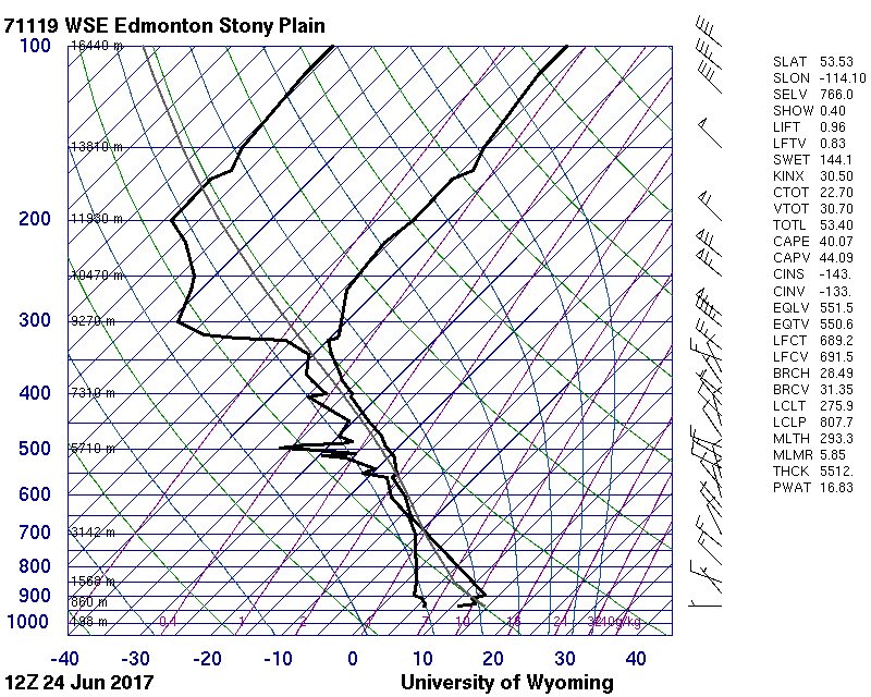
Upper-air stations, of which there are 31 across Canada, are locations where a compact set of instrumentation is attached to a large balloon and launched into the atmosphere. The instrumentation measures temperature, dew point1, wind direction and speed, and pressure. These measurements are combined to create a graph called a sounding and gives weather forecasters an understanding of how the atmosphere changes in the vertical.

These measurements are also crucial in supplying accurate data for weather models to ingest and use for their forecast production.

An example of a sounding graph created from data obtained by a morning launch from the upper air site in Stony Plain, AB.

The loss of the Kelowna sounding site will have a direct impact on the ability to forecast weather in the region, as well as likely contributing to a small degradation in the quality of weather models.

There is a quote in the CBC article that should be pointed out as wrong:

The data collected at the Kelowna Upper Air Station is not essential for local weather forecasting, according to ECCC, but the station is an important source of information for weather models.

In the world of weather forecasting, real data is the single most valuable resource. Forecasters have more weather models spitting out forecasts than they can reasonably assess2 but models can only be so accurate. Real data, while significantly less in quantity, is the real deal and crucial for many forms of weather forecasting. The soundings generated from these upper air sites are actively used by meteorologists to help them forecast weather such as: thunderstorms and thunderstorm severity, freezing rain, snowfall intensity, blizzards3, and drizzle/freezing drizzle.

The measurements taken by upper air stations provide crucial information used meteorologists for improving the accuracy of severe summer weather forecasting.

Here at A Weather Moment, we’ll use whatever real soundings we determine could be representative of what the weather here will be like4 before resorting to using model-generated soundings. They are a very important piece in the puzzle of weather forecasting.

Lastly, I think one of the questions that needs to be raised is what value ECCC assigns to upper air data. The CBC article states that they’ve known of the plans for 2 years already, but in the meantime have developed no plan for what to do about it. It seems like that would be ample time to create a plan for relocation in case it was needed, but the article paints a picture that shows an unprepared organization that has to close the site while they figure out what to do. The situation as presented seems to suggest that ECCC has devalued upper air data, which would be of deep concern to me.

Over the past winter, I decided to keep an eye on how well the models handled the forecast of major storm systems at two points:

  1. Before they make landfall and are contained entirely in the Pacific with no upper-air stations able to launch balloons to sample them.
  2. Once they make landfall and are sampled by upper air sites.

I was interested in the results as the general trend in the modelling community has been to rely more and more on remote sensing; data that is generated not by being directly measured, but derived by running direct measurements through mathematical equations to calculate them. This is used often with satellite data. The idea is attractive: we have satellites that are looking at everywhere, so we could get these values everywhere instead of just where we have upper air stations. It seems perfect.

Unfortunately, the reality is that for many of the elements important for weather forecasting, the accuracy of remote sensing is simply not good enough yet. In The academic community, there has been a search for a replacement for sending up balloons for several years now that has led them through technologies such as LIDARS and WV-DIAL, but the accuracy has yet to reach a point where they can be relied on as replacements.

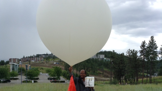
Technician Afeworki Mekonnen about to launch a weather balloon from the Upper Air weather station in Kelowna, B.C. Credit: CBC News/Afeworki Mekonnen

In my qualitative assessment of model performance over the winter, I found that before these storm systems reached land, model forecasts were highly variable and there tended to be little agreement between different models. Once they reached the west coast, however, and began being sampled by actual upper air stations, the models quickly trended towards similar solutions, with greater consistency in the forecast from run to run. Given the wide variety of storms that I kept track of through the winter that spanned a wide range of intensities and speeds, I don’t think that the improvement in forecast skill is simply a correlation. I’m willing to say that upper air stations make forecasts better, both those generated by weather models and those improved on by meteorologists.

But it doesn’t end there. Also mentioned on Saturday via Twitter:

I can only hope that the short-term closure at Iqaluit is not a further indication on a devaluation of upper air data. The quality of remotely-sensed data will continue to gradually improve, but it still can’t match the quality provided by balloon launches at upper air stations. If Canada is serious about improving the quality of the weather forecasts it offers Canadians, it needs to be serious about improving the density of its upper air stations across the country.


  1. The dew point is a measure of how much water the air contains. 
  2. Off the top of my head: RDPS, GDPS, REPS, GEPS, NAM, 3km NAM, RAP, HRRR, HRRRX, GFS, ECMWF, CFS, ECMWF… 
  3. Both of the heavy snow and wind variety as well as the more common “clear sky” blizzards produced by strong winds in much of the eastern Arctic and portions of the eastern Prairies. Clear sky blizzards are fairly common in the Red River Valley. 
  4. The closest upper air stations to Winnipeg are in International Falls (MN), Bismarck (ND), and The Pas (MB). 

NASA Shares First Images From GOES-16

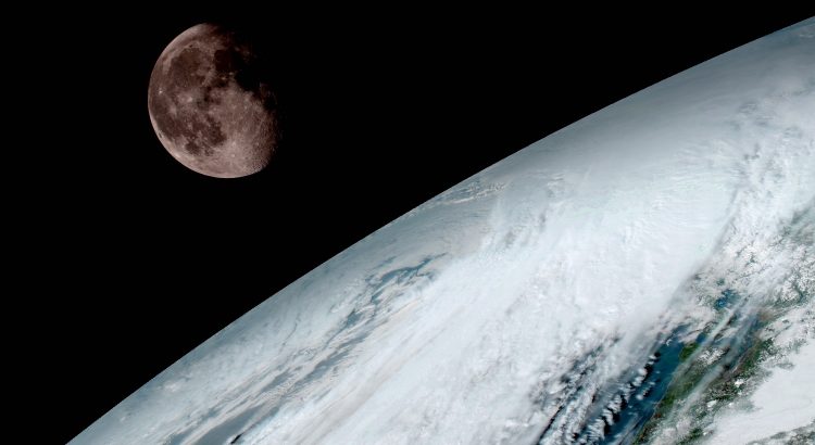
NASA has shared the first images from GOES-16, a new satellite launched in November. GOES-16 is notable for being a truly next-generation weather satellite that will dramatically increase the quantity and quality of satellite-based weather information.

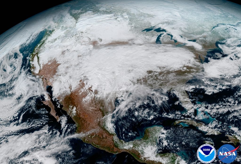
This image clearly shows the significant storm system that crossed North America that caused freezing and ice that resulted in dangerous conditions across the United States on January 15, 2017 resulting in loss of life. GOES-16 will offer 3x more spectral channels with 4x greater resolution, 5x faster than ever before. Credit: NASA

GOES-16 has 6 instruments onboard, two of which are related to weather. The Advanced Baseline Imager, which is the camera that looks down on the earth, will take pictures that are clearer and more detailed than current satellites. It can also scan half the earth, known as a “full-disk” scan, in 5 minutes. If NWS forecasters need to focus on severe weather, GOES-16 can provide smaller-region images every 30 seconds. This is faster than RADAR imagery can even be produced.

The images provided in the linked gallery above are seriously impressive. While the everyday imagery used in weather forecasting won’t be processed to look the same as these images are, the detail present will still be there. I can see this fundamentally shifting our understanding of the weather and allow both meteorologists and weather modellers to improve their forecasting abilities.

GOES-16 was formerly known as GOES-R and was launched on November 19, 2016.

GOES-16 will undergo testing and calibration for much of 2017. It is planned to go operational in November.

A press release regarding these images is available here.