Cool Friday Followed By Weekend Warming

Winnipeg will see below-seasonal temperatures for one more day before a gradual return to summer heat.

A ridge of high pressure moving into the region will continue to keep things cool and breezy in Winnipeg today. With mixed skies, the city should see temperatures climb to a high near 15°C with north-northwest winds of 20 to 30 km/h. The winds will ease this evening with clearing skies. Temperatures will be quite cool with the low dipping to around 1°C at the airport and closer to 3 or 4°C downtown.

The high pressure centre will drift south of the region on Saturday, leaving behind sunny skies and light west-northwest winds. With all-day sunshine, temperatures will be a bit warmer with a high near 20°C. Skies will stay clear on Saturday night with a low near 6°C.

NAM 2m Temperature Forecast valid 21Z Sunday May 31, 2020
Summer temperatures will return to the Prairies by Sunday.

Warmer weather will continue to edge eastwards across the Prairies on Sunday. Winnipeg will see temperatures return to a seasonal high of 23°C under partly cloudy skies. Winds will be light for much of the day before picking up late in the afternoon into the 20 to 30 km/h range. Temperatures will stay mild on Sunday night with a low near 13°C with the southerly winds continuing. There will be a chance of showers or thunderstorms overnight as a warm front pushes across southern Manitoba.

Long Range Outlook

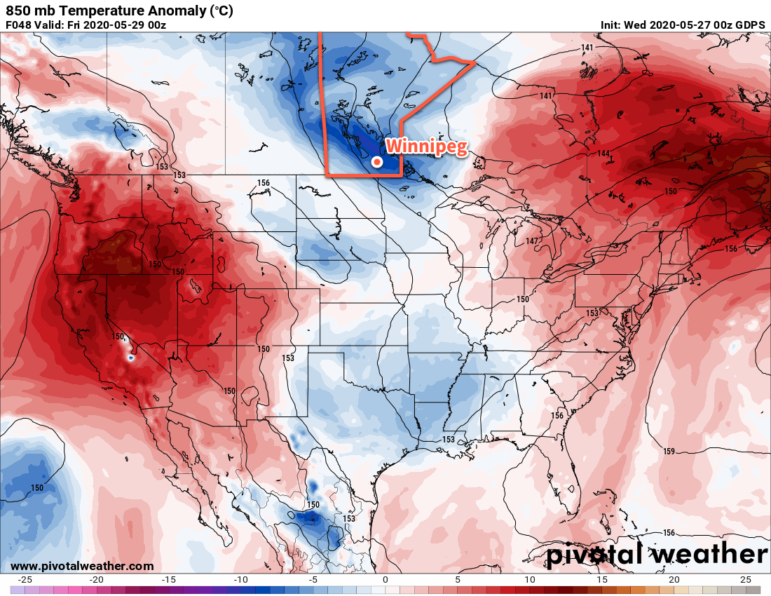
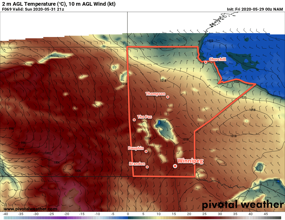
Next week will bring hot summer weather back to Winnipeg with highs in the 25 to 30°C range. There may be several chances for showers or thunderstorms through the first half of the week, then quieter conditions are forecast until a low moves through next Saturday.

Today’s seasonal daytime high in Winnipeg is 22°C while the seasonal overnight low is 8°C.

Cold Front Brings Windy, Cool Weather

A cold front moving through southern Manitoba today will usher in windy and cooler conditions for the rest of the work week.

Today will be a comparatively pleasant day in Winnipeg with plenty of sunshine. Temperatures should reach a high near 24°C with gusty winds picking up out of the west into the 30 to 40 km/h range. The winds will ease up tonight as temperatures head to a low near 11°C under mainly clear skies.

GDPS 850mb Temperature Anomaly Forecast valid 00Z Friday May 29, 2020
The forecasted 850mb temperature departures from seasonal values show the cooler air mass moving into the province for the end of the week.

For Thursday and Friday, an upper trough moving across southern Manitoba will usher in much cooler weather. Skies will cloud over with a slight chance of showers on Thursday morning, leaving the city with mostly cloudy skies until Saturday. Northwest winds of 30 gusting 50 km/h will usher in much cooler temperatures, limiting Winnipeg’s high to the lower teens both Thursday and Friday. The winds will ease on Thursday night, then return into the 20 to 30 km/h range on Friday. Overnight lows both Thursday and Friday nights will be near 5°C.

Long Range Outlook

Temperatures will return to seasonal values through the weekend with plenty of sunshine. Warmer air will push into the province Sunday night, bringing with it the potential for some unsettled conditions. Heading into next week, hot weather returns to Winnipeg with highs in the upper 20s and overnight lows in the mid-teens.

Today’s seasonal daytime high in Winnipeg is 22°C while the seasonal overnight low is 8°C.

Seasonal Weather Returns to Winnipeg

Winnipeg will see seasonal conditions over the coming days with increasing sunshine.

After a mostly cloudy start to the day, the cloud cover should begin to break up this morning. With mixed skies through the rest of the day, Winnipeg will see temperatures climb to a high near 23°C. Winds will be light out of the north today as a ridge of high pressure moves towards the area. Skies will stay mixed to cloudy tonight as a low pressure system in Minnesota lifts towards Lake of the Woods. It will spread showers across southeastern Manitoba through the night. The rain should stay to the south and east of Winnipeg, but there is a chance that a few passing showers graze the city overnight. Temperatures will dip to a low near 12°C.

NAM 12-hour Accumulated Precipitation Forecast valid 18Z Tuesday May 26, 2020
Showers will clip through southeastern Manitoba on Monday night.

Skies will clear out on Tuesday with a high near 25°C. Winds will shift to the south to around 20 km/h in the afternoon as a low pressure system approaches through Saskatchewan. The city will see mixed skies on Tuesday night with a slight chance of a shower as a cold front swings through. Temperatures will dip to a low near 14°C.

On Wednesday, skies will clear quickly behind the cold front with westerly winds picking up into the 30 to 40 km/h range. The city will see a high near 23°C. Winds will ease to around 20 km/h on Wednesday night as temperatures dip to a low near 10°C.

Long Range Outlook

Cooler temperatures will move in for the second half of the week with highs in the mid-teens and lows down to the mid-single digits. No notable precipitation is in the forecast for the rest of the work week. Heading into the weekend, warmer weather will begin to push back into the region with highs approaching 30°C to start next week!

Today’s seasonal daytime high in Winnipeg is 22°C while the seasonal overnight low is 8°C.

Warm And Unsettled Weather Ahead

The warm summer temperatures will gradually cool back to seasonal values this weekend as a cold front pushing east brings unsettled conditions to the region.

Today will be a beautiful day in Winnipeg as temperatures head to a high near 27°C under partly cloudy skies. Winds will continue as they have the past several days, strengthening out of the south to 30 gusting 50 km/h. By late in the day, a chance of thunderstorms will develop over the southwestern corner of the province into the Interlake. Winnipeg may have a chance of seeing some activity, but it looks likely that it will stay west and north of the city. Temperatures will head to a low near 16°C tonight with southeast winds near 20 km/h and partly cloudy skies.

Saturday will bring mixed skies to the region with a good chance of showers and a chance of thunderstorms. Temperatures will climb to a high near 26°C with southerly winds of 20 to 30 km/h. In the evening, a cold front will begin moving across the Red River Valley. Moderate instability will develop ahead of the front, likely triggering a line of showers and thunderstorms as it moves through. The rain will move northeastwards along the front as it slowly crosses the Red River Valley. Lows will dip a bit cooler to around 13°C behind the front on Saturday night.

NAM 2m Temperature Forecast valid 03Z Saturday May 24, 2020
A cold front pushing across the Red River Valley on Saturday evening will bring a chance of showers or thunderstorms to the region.

On Sunday, a disturbance lifting northeastwards across North Dakota will spread cloud and showers into southern Manitoba. While the southern Red River Valley will see some rain, it’s less likely here in Winnipeg. Most guidance suggests that the rain will remain just south of the city with a chance of a few showers as it passes by. While there is good agreement on the current track, if the disturbance ends up a bit further north then it could be a rainy day for the city. Temperatures will climb to a near-seasonal high of 20°C with northerly winds of 20 to 30 km/h. Temperatures will head to a low near 11°C on Sunday night with cloud cover breaking up and winds easing.

Long Range Outlook

Next week is looking pleasant with seasonal to slightly above-seasonal temperatures. Winnipeg should see plenty of sunshine, but some unsettled weather may be possible midweek with a chance of showers or thunderstorms.

Today’s seasonal daytime high in Winnipeg is 21°C while the seasonal overnight low is 7°C.