Warming Temperatures Bring More Showers

Temperatures will continue to climb through the second half of the week in Winnipeg. After some mid-week sun, another round of showers is likely on Friday.

Winnipeg will see any left over cloud from yesterday’s system clear out this morning as a ridge moves across the province. The city will see a high near 17°C this afternoon. Temperatures will dip to a low near +4°C tonight with just a few clouds.

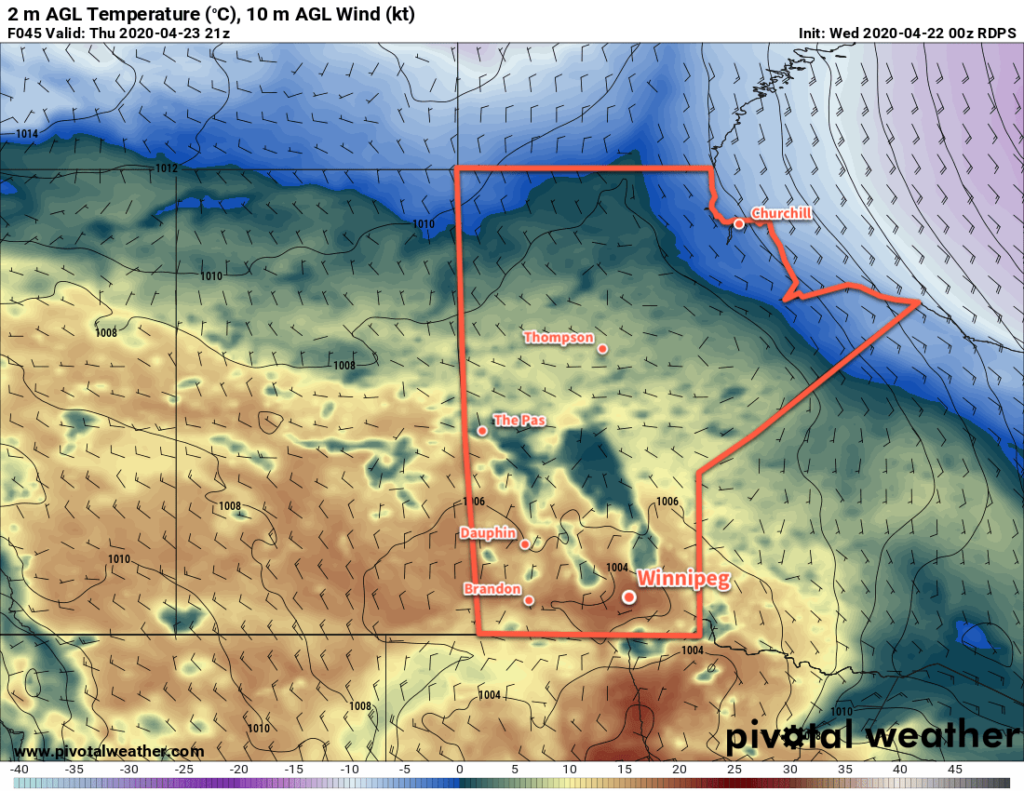
On Thursday, the next low pressure system will begin pushing east across the Prairies. Southerly winds will strengthen to 30 gusting 50 km/h through the day as warmer air spreads into the region. Winnipeg will see temperatures climb to around the 20°C mark under increasing cloud. Skies will stay cloudy on Thursday night with temperatures dipping to a low near 11°C.

NAM 24hr. QPF Forecast valid 12Z Saturday May 2, 2020
A low pressure system crossing Manitoba on Friday will bring showers to southern portions of the province and a broad swath of rain from western to northeastern regions.

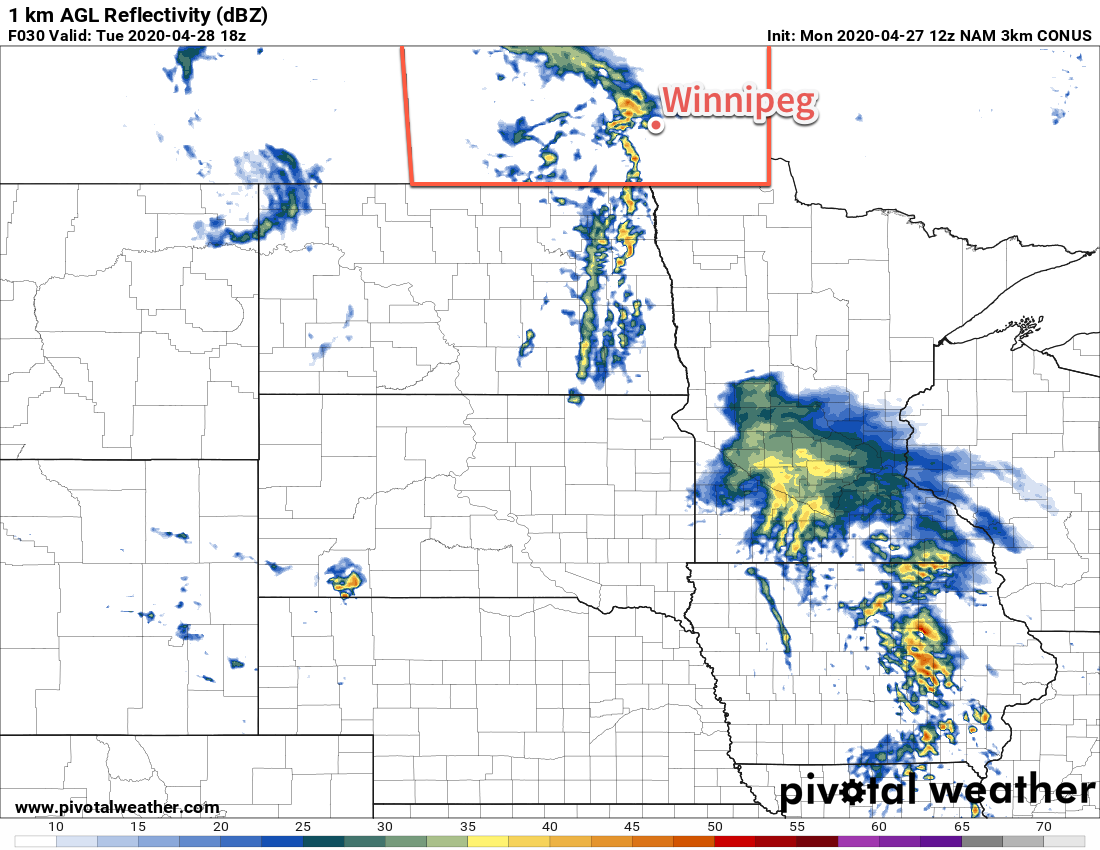
On Friday, a shortwave will eject northeastwards out of Montana and lift across southern Manitoba. As it moves through, it will support an area of showers that will move across the Red River Valley along with plenty of cloud cover. Winnipeg will see temperatures reach a high near 17°C with southerly winds of 20 to 30 km/h. The winds will shift westerly and pick up a little bit in the evening as the low passes. Temperatures will dip to a low near 9°C.

Long Range Outlook

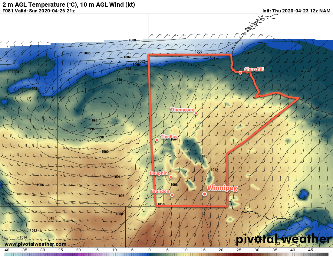
Temperatures will dip below seasonal values this weekend as cold upper low makes its way across the Prairies. Although seasonably cool, it should be dry with just a few clouds. Seasonal temperatures will build back into the province next week.

Today’s seasonal daytime high in Winnipeg is 15°C while the seasonal overnight low is 2°C.

Seasonal Spring Temperatures With a Few Showers

Spring weather continues in Winnipeg this week with seasonal temperatures and another round of showers or thunderstorms.

Today will be a beautiful day in Winnipeg as a weak ridge moves through. With west-northwest winds near 20 km/h and plenty of sun, temperatures will climb to a high near 16°C. An approaching low will begin to spread cloud into the region overnight with temperatures dipping to a low near 7°C.

Skies will be mostly cloudy in Winnipeg on Tuesday as a low pressure system slides across the southwestern corner of the province. Winnipeg will see a high near 15°C with light easterly winds. Showers will spread eastwards into the Red River Valley through the day. Amounts will be highest near the western escarpment where the easterly winds will help enhance precipitation. In these areas, 10 to 20 mm of rain is possible. Amounts will diminish eastwards across the Red River Valley. Embedded within this area of showers will be the potential for an embedded thunderstorm or two. The instability is weak with limited bulk shear, so if any occur they would be weak with no notable threat posed.

3km NAM Forecast 1km RADAR Reflectivity valid 18Z Tuesday April 28, 2020
Showers with the risk of isolated thunderstorms will push across the Red River Valley on Tuesday.

The showers will taper off through the evening, lingering along the western escarpment longer than elsewhere. Winds will pick up out of the north into the 20 to 30 km/h range for much of the night. Winnipeg will see temperatures dip to a low near +2°C.

Another weak ridge will move across the province on Wednesday, bringing clearing skies as temperatures climb back to a high near 16 or 17°C. Temperatures will dip back down to a low around +4°C on Wednesday night.

Long Range Outlook

Warm weather will return for the second half of the week with temperatures likely reaching 20°C on Thursday and Friday. Another disturbance moving through will bring a chance of showers on Friday. Seasonal to slightly below-seasonal temperatures will return fo the weekend with plenty of sunshine.

Today’s seasonal daytime high in Winnipeg is 15°C while the seasonal overnight low is 2°C.

Mild Spring Temperatures Continue

Winnipeg will see a mixed bag of weather over the coming days, but the warmer spring weather isn’t going anywhere.

A ridge of high pressure moving across the Red River Valley will bring partly cloudy skies and light winds to Winnipeg today. Temperatures will stay seasonably mild with a high near 15°C. A disturbance moving across Saskatchewan will push showers into southwestern Manitoba through the afternoon. More cloud cover will build eastwards through the evening hours as temperatures head towards a low near +3°C. There will be a chance of showers tonight in Winnipeg, but they will likely remain west of the city.

Saturday will bring cloudy skies to Winnipeg as showers continue to sit over southwestern Manitoba. They’ll slowly creep eastwards through the day, but Winnipeg won’t see any chance for rain until late in the afternoon. It’s likely that much of the shower activity will slide to the south of the city as it tapers off in the evening. The cloudy skies will keep temperatures a bit cooler with a high near 13°C.

Overnight lows both Friday and Saturday night will be in the low single digits.

On Sunday, a strong low pressure system will track across the northern Prairies, spreading mild temperatures eastwards. Unfortunately, between the approaching low and departing high, windy conditions will develop over the Red River Valley. Southerly winds will strengthen to 40 gusting 60 km/h for the afternoon with temperatures climbing back up to 17°C. The morning will bring mixed skies, then clouds will move in through the afternoon as the disturbance begins moving into the Red River Valley.

Winnipeg will see a chance of showers on Sunday evening as the warm front moves through. The cloud cover will then begin breaking up as the wind drops off and temperatures dip to a low near 6°C.

Long Range Outlook

Next week will start off with mild temperatures possibly reaching 20°C before cloudier conditions develop for Tuesday with the chance of showers. After an unsettled Tuesday, mild temperatures will return with highs in the mid- to upper-teens through the rest of the week.

Today’s seasonal daytime high in Winnipeg is 14°C while the seasonal overnight low is +1°C.

Spring Arrives

Winnipeg will finally see pleasant, seasonably mild conditions through the rest of the week.

Winnipeg will shake off the cool grip of winter today as milder spring weather moves into the region. The story for the next few days is short, sweet, and great news for those waiting for conditions to improve.

Temperatures will climb back to seasonal values today with a high near 13°C, but will climb even higher on Thursday into the mid- to upper-teens. A low pressure system exiting northern Manitoba on Friday will send highs back down to a seasonal 13°C. Overnight lows will hover near the freezing mark through the rest of the work week.

RDPS 2m Temperature Forecast valid 21Z Thursday April 23, 2020
The warmest temperatures so far this spring will move into the Red River Valley on Thursday.

Winnipeg will see a mix of sun and cloud over the next three days through a combination of daytime heating and the occasional passing disturbance. Things should stay dry for the most part, except for Thursday when a few passing showers are possible.

Long Range Outlook

The weekend should bring much of the same weather with seasonal temperatures continuing. Beginning Sunday night into the first half of next week, conditions may turn more unsettled with several chances for rain.

Today’s seasonal daytime high in Winnipeg is 13°C while the seasonal overnight low is 0°C.