RDPS 2m Temperature Forecast valid 03Z Saturday February 8, 2020

Cold End to the Week, Milder Temperatures Return for the Weekend

An Arctic high will bring cold weather to Winnipeg today, but seasonal temperatures return alongside some flurries for the weekend.

A sprawling Arctic high will move through southern Manitoba today, bringing with it colder weather. Winnipeg will see a seasonably cold high of -18°C with light winds. Skies will stay sunny for most of the day, but there will be a chance of some cloud moving in late in the day as it drifts towards the region from the northwest. Cloud cover will continue to build in tonight with southerly winds of 10 to 20 km/h. A weak warm front pushing into the region will help keep temperatures a tad warmer than last night with a low near -24°C.

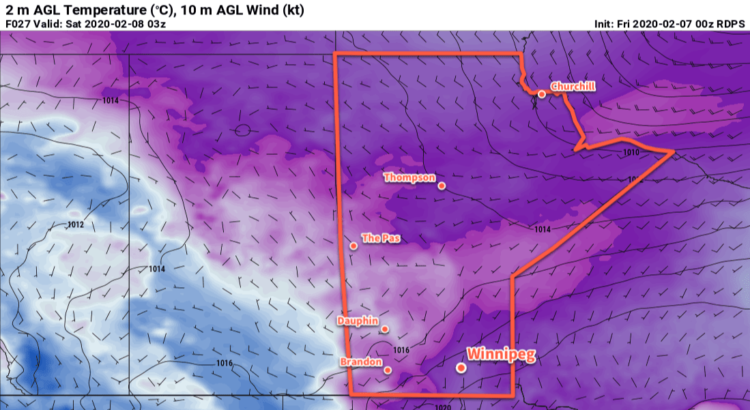
Saturday will bring mostly cloudy skies as an upper-level disturbance rolls over the region. Temperatures will rebound nicely to a near-seasonal high of -11°C with light winds. Some flurries will move through over the course of the day, but will be most likely through the morning hours. The cloud will break up a bit for Saturday night as temperatures head to a low near -20°C.

The city will see mixed to cloudy skies on Sunday as another low pressure system begins to build across Saskatchewan. Temperatures will climb back to around -9°C, but winds will pick up out of the south to around 30 km/h through the afternoon. Those winds will persist through the night alongside cloudier skies and keep temperatures steady around -10°C.

Long Range Outlook

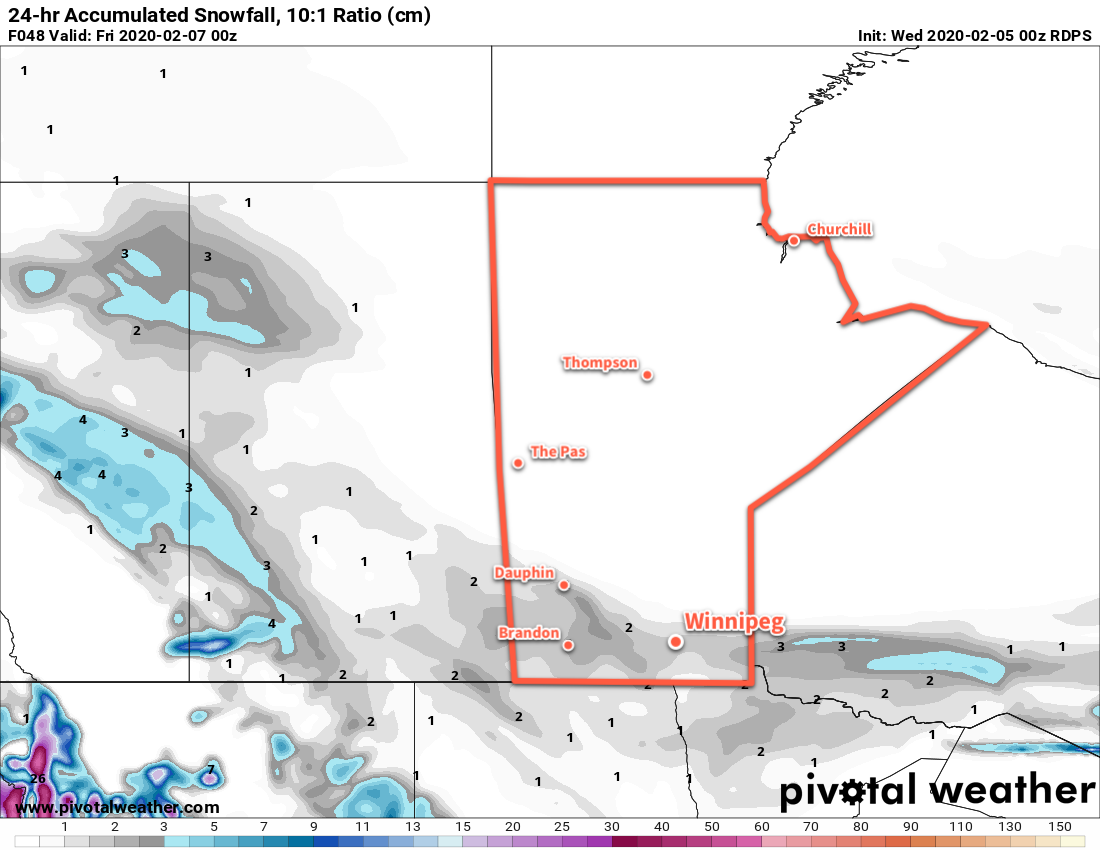
More flurries are likely on Monday as mild air continues to push into the region. Temperatures will stay seasonably warm through Tuesday with highs climbing to around -6°C. A cold front is forecast to sweep through mid-week, bringing a chance for some more light snow and a return of colder weather. Through the second half of the week, daytime highs are forecast to drop back into the -15 to -20°C range with overnight lows dipping into the -20 to -25°C range.

These cooler conditions will likely stick around through the weekend; the shift in temperatures will be largely driven by the polar vortex as it shifts back from the High Arctic into Hudson Bay, bringing bitter cold to Canada’s eastern Arctic and supply colder air to the eastern Prairies.

Today’s seasonal daytime high in Winnipeg is -10°C while the seasonal overnight low is -20°C.

Becoming Cooler With Light Snow

Winnipeg will see mild temperatures today give way to cooler temperatures and light snow as a cold front drifts southwards.

The city will enjoy a mild high near -6°C today as sunny skies slowly give way to increasing cloudiness in the afternoon. Winds won’t be too much of an issue either with morning southerlies of 20 to 30 km/h easing off through the morning. Temperatures will begin to fall as the cold front moves into the region this evening and skies fully cloud up. Winnipeg will see a low near -15°C with some light snow beginning overnight.

Thursday will bring cloudy skies to the city with flurries as temperatures recover only a couple degrees to a high near -13°C. Winds will persist out of the north in the 20 to 30 km/h range through the day. The snow will taper off sometime midday into the afternoon as drier air pushes in. It won’t pile up too much, but the city could see a couple centimetres by the time it ends. Heading into the evening, winds will ease as temperatures head to a low near -23°C.

RDPS 24hr. Accumulated Snowfall (10:1 SLR) valid 00Z Friday February 7, 2020
Much of southern Manitoba will see around 2 cm of snow with a cold front passage Wednesday night into Thursday.

A ridge of high pressure will slump through the Red River Valley on Friday, bringing gradually clearing skies and cool temperatures. Winnipeg will see a seasonably cool high near -15°C and light winds. Temperatures will dip to a low near -20°C and then warm as some cloud moves in with an approaching warm front.

Long Range Outlook

Winnipeg will see variable cloudiness this weekend with a chance of flurries on Saturday. Temperatures will hover around seasonal values, then see a brief warm-up on Monday. The rest of next week looks to bring the chance of occasional flurries as temperatures gradually cool.

Today’s seasonal daytime high in Winnipeg is -10°C while the seasonal overnight low is -21°C.

Cool Start, Then Warming Mid-Week

Cooler temperatures return to start Winnipeg’s week as an Arctic high moves through the Prairies. The cold will be short-lived, though, with milder temperatures expected to return mid-week.

Winnipeg will see partly cloudy skies with a seasonably cool high near -14°C today. The colder weather is moving into the region with an Arctic high that’s building across the Prairies behind a low that moved through overnight. These cooler conditions will also be joined by a northwesterly wind of 20 to 30 km/h today. This will produce wind chill values in the -20 to -25 range through the day, so it’ll feel noticeably chillier than just the temperature might make you believe.

Some cloud cover will move through tonight as temperatures drop to a low near -23°C with light winds. This will be the coldest night since the temperature dipped to -28.7°C on January 20th. There will be a chance of some light, non-accumulating flurries as the cloud moves through overnight.

RDPS 2m Temperature Forecast valid 06Z Tuesday February 4, 2020
Cooler temperatures will return to southern Manitoba on Monday night as an Arctic high moves across the Prairies.

Tuesday will see the Arctic high dropping to our south with a ridge extending northwards through the province. This will keep temperatures cold with a high of just -16°C and – as soon as the overnight cloud clears out – plenty of sunshine. With the ridge over the region winds should stay light through the day out of the west-southwest.

A low pressure system will move across northern Manitoba on Tuesday night, spreading slightly warmer air across the southeastern Prairies. Winds will pick up out of the south overnight to 20 to 30 km/h as temperatures rise to around -12°C by morning.

Wednesday will bring increasing cloud to Winnipeg with a mild high near -6°C. The southerly winds will be quite noticeable to star the day at 30 gusting 50 km/h, but will ease heading into the afternoon. Skies will become increasingly cloudy through the day with a chance of light snow in the evening and overnight as a cold front pushes into the region. Temperatures will dip to a low near -10°C on Wednesday night with northerly winds of 10 to 20 km/h.

Long Range Outlook

It looks like seasonal conditions with variable cloudiness will stick around for the rest of the work week and the weekend. Temperatures will hover around seasonal values and other than the occasional chance of flurries, there is no notable snowfall in the next 5 to 7 days.

Today’s seasonal daytime high in Winnipeg is -10°C while the seasonal overnight low is -21°C.

Warmer, Windy Weather Ahead

Winnipeg will see warm and windy weather this weekend with a chance of seeing the sun again!

A disturbance crossing Manitoba today will start bringing drier air into the province and help clear out some cloud. In the Red River Valley, southerly winds will pick up into the 20 to 30 km/h range this afternoon, but the clouds will linger. There will continue to be a chance for freezing drizzle or flurries as temperatures head to a high near -3°C. A trough moving through this evening will usher in westerly winds that will start to break up the cloud cover. Temperatures will dip to a low near -7°C as winds ease.

Saturday will mark the beginning of Winnipeg’s windy weekend as a warm front pushes into the region. Winds will pick up out of the south again to 30 gusting 50 km/h with more cloud than sun. Temperatures will climb towards 0°C through the day, then up above freezing in the evening as winds shift to the southwest. Skies will stay mixed overnight with temperatures dipping back below freezing for Sunday morning.

RDPS 2m Temperature Forecast valid 00Z Sunday February 2, 2020
A warm front will push across the Red River Valley on Saturday evening, ushering in above-freezing temperatures.

A cold front will slump southwards through the Red River Valley on Sunday, bringing more cloud into the region and strengthening west-northwest winds. The Red River Valley will see winds strengthen to 30 gusting 50 km/h except for the western escarpment region where gusts up to 60 km/h will be likely. The organized snow associated with this system will likely stay north of Winnipeg, crossing through the southern Interlake.

ECMWF 24hr. Accumulated Snowfall Forecast (10:1 SLR) valid 00Z Monday February 3, 2020
The organized snowfall with this system will cross through the southern Interlake, leaving Winnipeg with a chance of flurries as the cold front slumps southwards.

The city will likely see mixed skies through the day with a chance of flurries. There could be a chance of patchy freezing rain, but it’s too early to say with any certainty. Winds will gradually taper off on Sunday night as skies clear with temperatures dipping to a low near -13°C.

Long Range Outlook

Temperatures return towards seasonal values to start next week as a ridge of high pressure builds into the region. The city will finally see some sunshine through the first half of the week with little cloud or snow expected. More cloud is forecast to move in through the second half of the week as warmer temperatures return.

Today’s seasonal daytime high in Winnipeg is -11°C while the seasonal overnight low is -21°C.