A Windy Climb to Warmer Weather

Winnipeg will see windy conditions develop later today as warmer temperatures push in from the west.

The prolonged stretch of below-seasonal temperatures in Winnipeg that began on February 3rd is finally coming to an end. A developing westerly flow aloft will spread milder Pacific air eastwards across the Prairies today. Unfortunately for Winnipeg, there will be a bit of a transition day before we shift into the warmer temperatures. Under a few clouds today, winds will remain light until later this afternoon. Southerly winds will increase to around 30 km/h by evening, persisting at 30 to 40 km/h through the night. These southerly winds will keep temperatures a bit cooler with a high near -7°C. Temperatures will remain fairly steady overnight, dipping to a low near -8°C with increasing cloudiness.
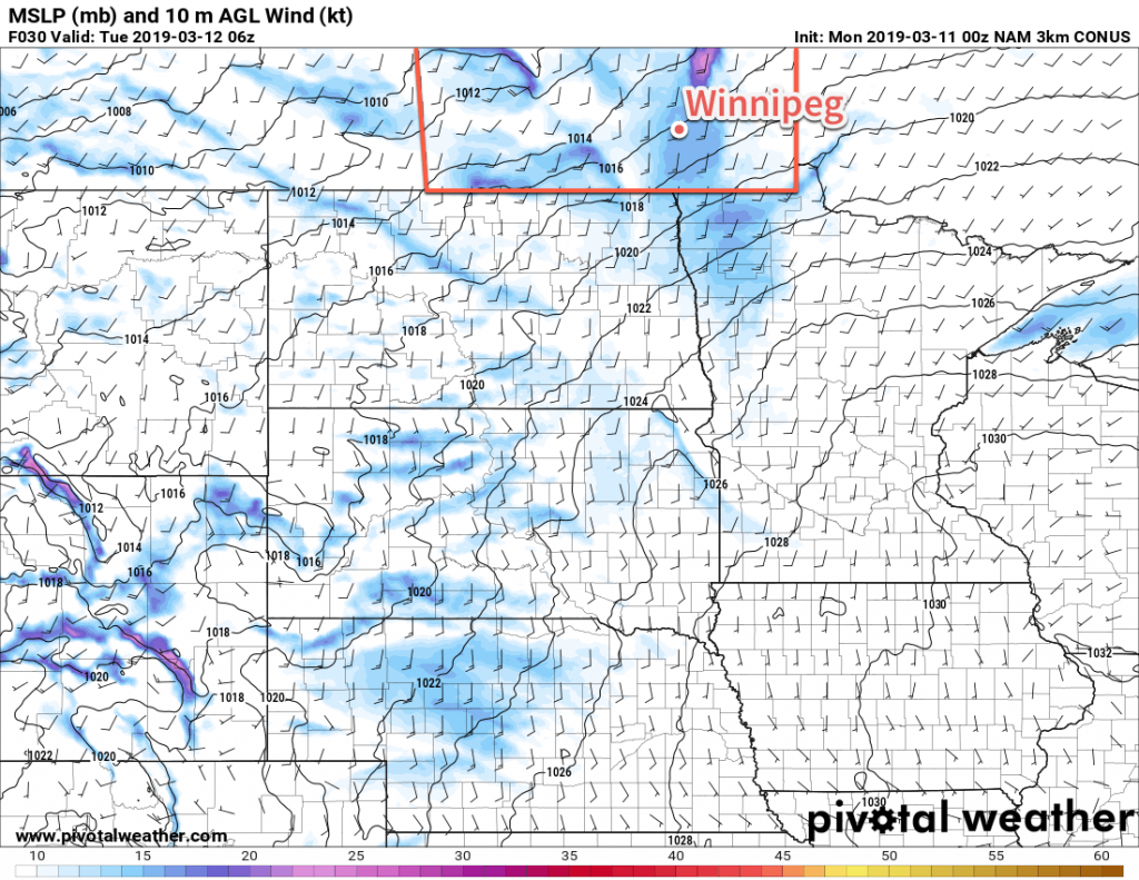
3km NAM Forecast 10m Wind valid 06Z Tuesday March 12, 2019
The Red River Valley will see moderate southerly wind on Monday night.

For Tuesday into Wednesday, a potent Colorado Low developing in the US will be the controlling force of the weather. While at one point it seemed the Red River Valley might see a major storm, forecasts continue to trend the system southeastwards. Now, it looks that southeastern Manitoba may see some snow, but that most of the province will escape it. Instead, the region will see plenty of low cloud and mild temperatures near the freezing mark.

The wind will diminish Tuesday and then remain calm until it begins picking up out of the north on Wednesday night.

We’ll be keeping an eye on the Colorado Low as it develops.

Long Range Outlook

Temperatures will cool to just a tad below seasonal values in the wake of the Colorado Low, but by the weekend temperatures are forecast to bounce right back to around the freezing mark. Combined with the increasingly strong sunshine, Winnipeg may just find itself entering the beginning of the spring melt!

Today’s seasonal daytime high in Winnipeg is -2°C while the seasonal overnight low is -13°C.
Seasonal Temperatures And A Bit of Snow

Winnipeg will see near seasonal temperatures through the weekend with snow developing Saturday and tapering off Sunday.

The main weather system impacting Winnipeg over the next few days will be a large Colorado Low system moving through the Northern Plains. It will spread warmer air northwards into southern Manitoba today, finally bringing a near-seasonal high to Winnipeg. That warmer air moving into the region will also produce mixed skies today as cloud cover builds northwards. Temperatures will stay mild tonight with a low near -10°C and mostly cloudy skies.

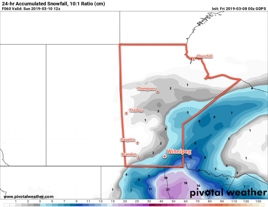
Winnipeg will see snow build into the region on Saturday. Snow will spread northeastwards out of North Dakota into the Red River Valley midday. The city will see a near-seasonal high of -3°C and light winds. The snow will ease on Saturday night, leaving around 3-5 cm in Winnipeg with amounts of 5-10 cm to the south and east. Breezy northwesterly winds near up to 30 km/h will move into the region in the evening. Temperatures will dip to a low near -10°C.

GDPS 24hr. Snowfall Accumulation (10:1 SLR) valid 12Z Sunday March 10, 2019
Snow will spread across southeastern Manitoba on Saturday.

The cloud cover will stick around for Sunday with a continued chance for some light snow. Northwesterly winds near 30 km/h will keep temperatures cooler than Saturday with a high near -5°C. Skies will clear out on Sunday night with temperatures dipping back into the low minus teens.

Long Range Outlook

Winnipeg will see a sunny day on Monday with near-seasonal temperatures, but the reprieve will be short-lived. Most guidance continues to forecast another major Colorado Low developing early in the week. Winnipeg would be under the influence of this system form Tuesday through Thursday, and it would bring the potential for a wintery mix of precipitation across the province. Snowfall may end up being a significant concern with this system; some models show the potential for a band of 20-30 cm of snow slicing across the Red River Valley. With flooding concerns mounting, a foot of heavy, wet March snow certainly wouldn’t help the situation.

Today’s seasonal daytime high in Winnipeg is -3°C while the seasonal overnight low is -13°C.
Seasonal Temperatures on the Horizon

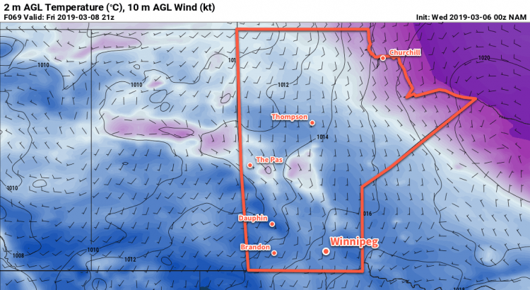
Winnipeg looks poised to break free of below-seasonal temperatures by the weekend. The city has seen seasonably cold temperatures entrenched over the region for much of February into the beginning of March.

Winnipeg will see fairly benign weather over the next few days as an Arctic high moves through the region. Be it cloudy periods today, mixed skies tomorrow, or increasing cloudiness on Friday, there will be cloud around through the remainder of the week.

Temperatures will be coldest today and tonight with highs and lows roughly 10°C below seasonal averages. The rest of the week will bring a gradual warming trend, reaching a high near -7°C on Friday. A few light flurries are possible over the next couple days, but forecasts show nothing of note.

Winds will be a bit breezy today out of the northwest at 20 to 30 km/h. The wind will then will diminish to calm as the Arctic high moves in tonight. Winds will remain calm or light out of the south for the remainder of the work week.

Long Range Outlook

The big shift in the weather will occur this weekend. A Colorado Low will push northeastwards through the American plains towards the Great Lakes. This system will bring some snow to the region, but the brunt of the storm will remain south of the border. The bigger impact of this storm will be how it shifts the large-scale pattern over North America.

As the Colorado Low pushes eastwards, it will finally dislodge the Polar Vortex from Hudson Bay. With the vortex gone, there will no longer be a persistent forcing of cold air southwards. This will allow seasonal temperatures to push into the region more frequently. The downside may be a more zonal pattern aloft. This pattern tends to result in more frequent disturbances moving through the region and chances for snow.

And while it’s still a long ways out, we have to mention that several models show the potential for a major winter storm next week. There’s no point in going into details, but we just want to note that some unpleasant winter weather may reappear for mid-March.

Today’s seasonal daytime high in Winnipeg is -4°C while the seasonal overnight low is -14°C.

Cool and Settled Weather On The Way

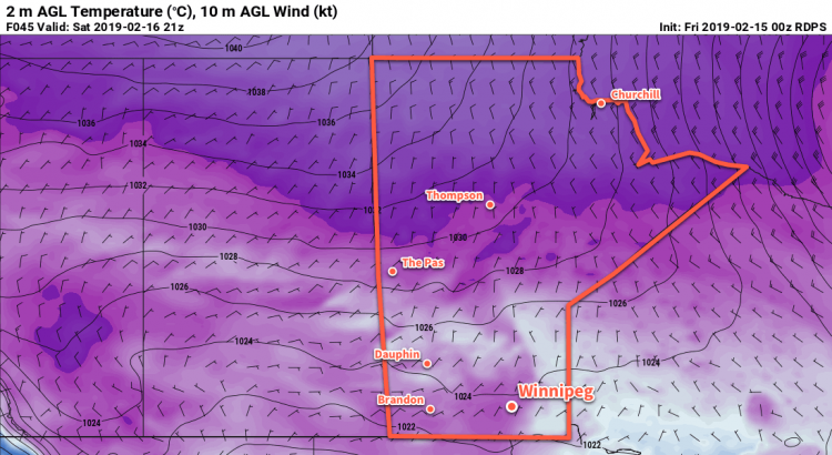
Winnipeg will head into an extended period of slightly cooler than seasonal temperatures and benign weather.

Winnipeg will see cool but comparatively pleasant conditions over the next few days. An Arctic high entrenched over the Prairies will weaken any passing disturbances right into next week. That said, Winnipeg will end the work week with sunny skies today and a high near -14°C. Unlike yesterday, winds will be light today, so conditions outside will be great for getting outside and enjoying winter activities. Temperatures will fall to a low near -27°C tonight, then gradually moderate early Saturday morning as cloud cover moves into the region.

Saturday will bring cloudy skies to Winnipeg as a disturbance slowly pushes eastwards into the Dakotas. Temperatures will warm up to a high near -12°C with light winds continuing. While south-western Manitoba may see some light snow, it doesn’t look like any will fall here in the Red River Valley. Temperatures will dip to a low near -21°C under cloudy skies on Saturday night.

Sunday will bring more cloud to the region with a high near -12°C again. Winnipeg will see a slight chance of flurries, particularly in the afternoon, but should escape any accumulating snow. Temperatures will dip to a low near -22°C again with some clear breaks developing.

Long Range Outlook

Next week looks cool and dry for Winnipeg. The city will continue to see high temperatures in the -10 to -15°C range with overnight lows near -20°C. While the week will bring variable cloudiness, it does not look like the region will see any accumulating snowfall.

Today’s seasonal daytime high in Winnipeg is -8°C while the seasonal overnight low is -18°C.


Extended Forecast Break Ahead
This will be the last forecast post for the next while as I’m taking a break from things and entering into a bit of vacation time. We’ll be back with a forecast again on March 6, 2019. In the meantime, we suggest you stay up to date with forecasts and alerts from ECCC. Their website is here and you can get their brand new app on iOS and Android.