Summer Heat Arrives, Smoke Tags Along

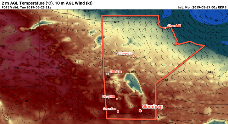
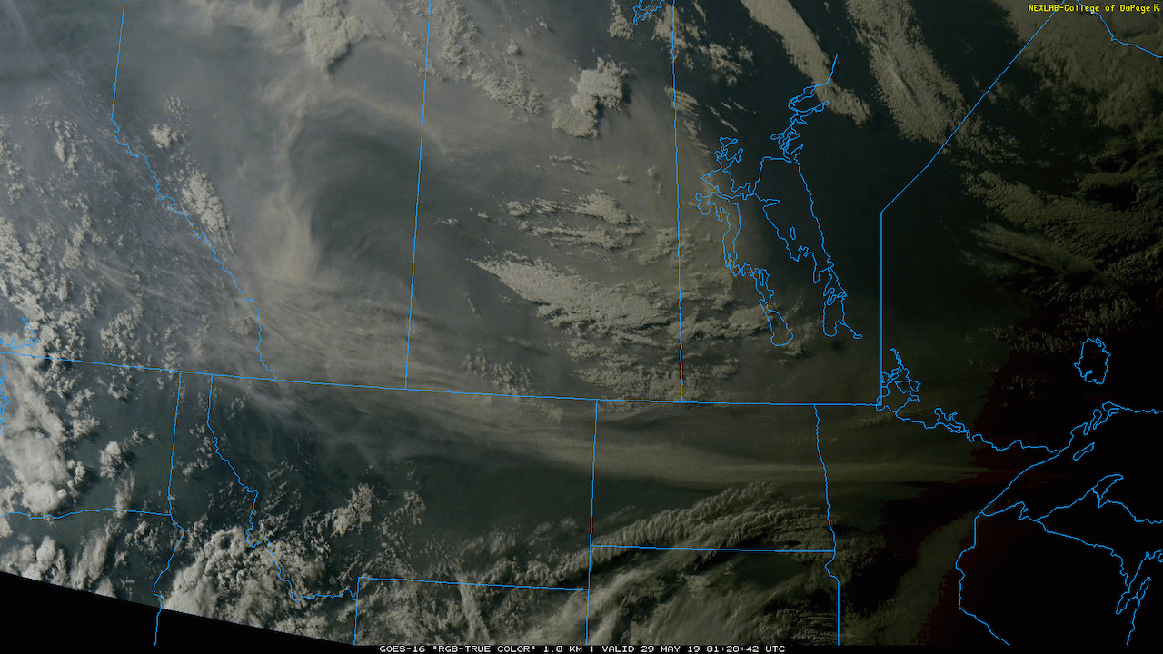
A push of warmer temperatures into Manitoba will send daytime highs soaring into the upper 20s today. Joining the warmth will be hazy skies as smoke from the northern Alberta forest fires moves in as well.

Winnipeg’s driving weather feature over the coming days will be an upper high shifting from northern Alberta to the Dakotas. It will have 2 major impacts for the region: warmer temperatures and smoke. First: the smoke.

As the upper high slumps southeastwards, the flow aloft will turn northwesterly. This will spread large amounts of smoke from the forest fires over northern Alberta across Saskatchewan into southern Manitoba. This smoke will be noticeable over the next few days, both aloft and as hazy conditions near the ground. If you have sensitivities to air quality be sure to keep an eye on the forecast AQHI values. Exactly when the smoke clears depends on how the large-scale weather pattern evolves near the end of the week. At this point it looks like there will still be some smoke and haze present on Friday with improvement on Saturday.

At sunset yesterday, a large plume of smoke over Alberta and Saskatchewan could is visible spreading into western Manitoba.

With the smoke out of the way, that leaves temperatures. While the smoke makes forecasting exact daytime highs tricky, this upper high will spread a hot air mass over part of the province. Temperatures will quickly climb into the mid-20’s by lunch today, then continue on to a high near 28°C this afternoon. Temperatures will stay warm tonight with a low near 13°C. Thursday will be another hot day with a high near 27°C. A cold front will push through on Friday morning, sending temperatures back to near-seasonal values to end the week.

Through all this, Winnipeg should see plenty of sunshine, albeit dimmed somewhat by the smoke. It doesn’t appear that Winnipeg will see any meaningful chances for rain, despite some cloud in the area Thursday morning as a warm front wavers through the region. The passage of the cold front also looks dry for Winnipeg.

Hot temperatures in the upper 20s and low 30s will be in place across the southern Prairies today and Thursday.

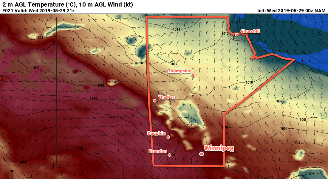
Winds will be light today, only picking up out of the north to around 15-20 km/h this afternoon and remaining light and variable on Thursday. On Friday, the wind will pick up out of the north to around 30 gusting 50 km/h behind the passage of the warm front in the morning.

Long Range Outlook

This weekend will bring more sunshine to Winnipeg with the smoke likely clearing out on Saturday. On Sunday, the warm weather will come surging back into the province with daytime highs climbing into the upper 20s again. This time, it doesn’t look like smoke will affect southern Manitoba; the upper flow will be more westerly than northwesterly, keeping the smoke further north.

Today’s seasonal daytime high in Winnipeg is 22°C while the seasonal overnight low is 8°C.

Temperatures Finally Heating Up

After a cloudy and unsettled weekend, summer weather will quickly return to Winnipeg.

Winnipeg will see settled conditions and increasing warmth as an upper-level ridge builds into the region. It will bring settled conditions to the region, giving Winnipeg plenty of sunshine over the next 3 days. Temperatures will make a welcome climb from highs near 20°C today into the mid-20’s for Tuesday and Wednesday.

The city will see light easterly winds today, but Tuesday will bring west-southwest winds into the 20 to 30 km/h range. Winds will ease back to light on Tuesday evening. Wednesday will bring a northerly shift to the winds with speeds likely remaining under 20 km/h.

Long Range Outlook

Temperatures will cool slightly for the second half of the week with daytime highs returning back towards the 20°C mark. The city will also likely see a bit more cloud, particularly on Friday when a passing system may bring some showers the region. Expect variable cloudiness this weekend with near-seasonal temperatures.

Today’s seasonal daytime high in Winnipeg is 22°C while the seasonal overnight low is 8°C.

Unsettled Skies Ahead for Winnipeg

Rain will spread over Winnipeg later this morning, kicking off a weekend of unsettled conditions for the region.

More rain is on the way for Winnipeg today as another low pressure system moves through. This system shares bears resemblance to Wednesday’s rain, but will track a bit further north and is a bit stronger. Rain will spread into southern Manitoba from North Dakota through the morning. The main area of rain will exit mid- to late afternoon, but the chance for showers will continue.

Rainfall totals for the region will be higher than seen on Wednesday. The highest amounts will fall close to the U.S. border with 15 to 25 mm by the time the rain tapers off. Rainfall amounts will diminish into the 10 to 15 mm range for Winnipeg and the Trans-Canada Highway corridor, then taper off to just a trace further north in western Manitoba across the Interlake. In Winnipeg, rain will taper off later this afternoon, but a few more showers are possible through the night. Temperatures will climb to around 14°C this morning, but once the rain moves in temperatures will dip to around 10°C. Winds will pick up out of the east into the 20 to 30 km/h range today.

Southern Manitoba will see a good soaking rain today with up to 20-25 mm of rian possible near the American border.

Winds will ease this evening with temperatures dipping to a low near 8°C overnight.

Saturday will bring mixed skies to the city. In the morning, there will likely be plenty of leftover cloud from Friday’s system, but that should break up for the afternoon. Once the sun pokes out, temperatures should manage to climb back up to a high near 19°C. The chance for showers will redevelop in Winnipeg overnight as skies cloud over and temperatures dip to a low near 8°C.

Sunday will bring more cloud and a continued chance for showers as the front stalls over the region. Temperatures should climb into the low teens with northeasterly winds up to around 20 km/h. Skies stay mostly cloudy Sunday night with another chance of showers as another disturbance crosses North Dakota. Temperatures will dip to a low around 5°C.

Long Range Outlook

The sun should reappear to kick off next week with temperatures climbing back into the upper teens and low twenties. A passing low might bring some showers to the region on Tuesday night, but otherwise it looks dry right through the end of the work week.

Today’s seasonal daytime high in Winnipeg is 21°C while the seasonal overnight low is 7°C.

Unsettled Conditions Ahead for Winnipeg

Winnipeg will see two chances for rain in the second half of the work week as two disturbances move through the province over the next few days.

The first of two disturbances will impact the region today. A band of showers will push northwards out of the Dakotas this morning, reaching Winnipeg by midday. As the showers push northwards, they will also weaken, making rain more likely near the U.S. border than here in Winnipeg. The chance for showers in Winnipeg will continue through the afternoon, then taper off overnight as the low pushes eastwards. The cloudy skies and breezy northeasterly winds near 30 km/h will keep things rather cool today. Winnipeg should see a high near 13°C. Skies will clear overnight with easing winds and a low near 7°C.

Showers will graze across southern Manitoba on Wednesday.

Thursday will bring pleasant spring weather back to the region. Winnipeg will see a few cloud sand a high near 22°C. Temperatures will dip to a low near 7°C on Thursday night with increasing cloud.

The next low pressure system to impact the region will push northeastwards into North Dakota on Friday. As it does so, it will spread an area of rain into southern Manitoba. This system looks to be more organized and slightly more intense than today’s system, so it looks likely that it will bring a swath of 5 to 15 mm of rain across much of the region.

Southern Manitoba is forecast to see a more organized rainfall on Saturday.

With the cloud and rain moving through, temperatures will once be cool with a high near 15°C. The rain should move out by Friday evening, leaving behind mostly cloudy skies as temperatures dip to a low near 8°C.

Long Range Outlook

The weekend will bring variable cloudiness to the city with another chance for showers Saturday night into Sunday as a cold front slumps southwards into the region. Highs will likely approach 20°C on Saturday but drop back into the mid-teens for Sunday. After the weekend, it looks like the weather pattern will stabilize a bit, bringing more sunshine and highs near the 20°C for next week.

Today’s seasonal daytime high in Winnipeg is 21°C while the seasonal overnight low is 7°C.