The summer heat that’s been in place over the region this week will come to an end as a cold front sweeps southwards.
A broad area of high pressure building in from the Arctic will cool temperatures towards seasonal averages across southern Manitoba this weekend.
Before the cooler weather arrives, though, southern Manitoba will have one more hot day. Another low pressure system moving towards the province will push more warm air into the southern portion of the province today. Daytime highs will again climb up to around 30 °C with plenty of sunshine this afternoon.
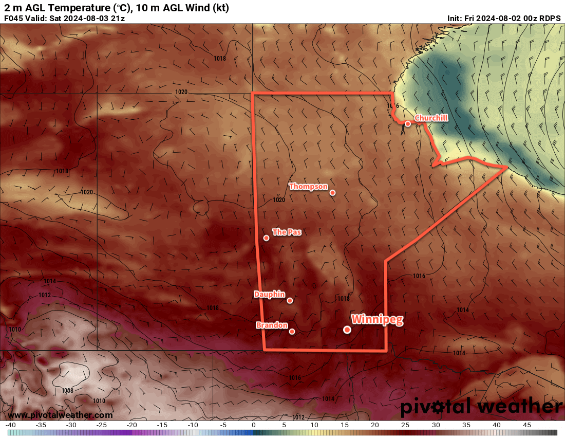
Conditions will finally change tonight when a cold front sweeps southwards. It will bring a chance of showers or thunderstorms to the region overnight into Saturday morning as it moves through. Temperatures will dip into the upper teens as light northerly winds develop.
The chance of rain will taper off on Saturday morning as north winds pick up into the 20–30 km/h range. Temperatures will climb up into the low- to mid-20s in the afternoon under partly cloudy skies. Heading into the night, temperatures will drop into the mid-teens with light north winds.
Sunday will bring a repeat of Saturday as a broad area of high pressure builds into the province. Temperatures will again climb into the low- to mid-20s under partly cloudy skies. Winds will be light out of the north through the day. Clouds may move in on Sunday evening as temperatures dip down into the low teens.
The other notable change for the weekend is that while lingering humidity may stick around through Saturday, much drier air will push into the region by Sunday, offering relief from the more humid weather of the past week.
Long Range Outlook
Next week will bring seasonably cool temperatures with daytime highs in the 20–25 °C range and overnight lows in the 10–15 °C. A partly cloudy start to the week could turn unsettled mid-week, but settled conditions should develop for the end of the week.
Today’s seasonal daytime high in Winnipeg is 26 °C while the seasonal overnight low is 13 °C.
Hot and humid conditions will continue this week in Winnipeg with the occasional chance of thunderstorms.
It will be a hot and humid day across southern Manitoba with daytime highs in the low 30s.
We’re back! This hiatus was longer than originally thought, but between minor burn-out with work, minor health concerns, travel, and a busy family schedule, there wasn’t much left in the tank by the time I could sit down and write. Things are in a better spot now, though! I’m rested — I was fortunate to be able to take much of July off — and the schedule is calming down. I hope to be back to writing twice weekly, but we’ll see how the summer schedule goes. That said, I’m starting this post off wanting to write instead of feeling like I have to write, which is a good start.
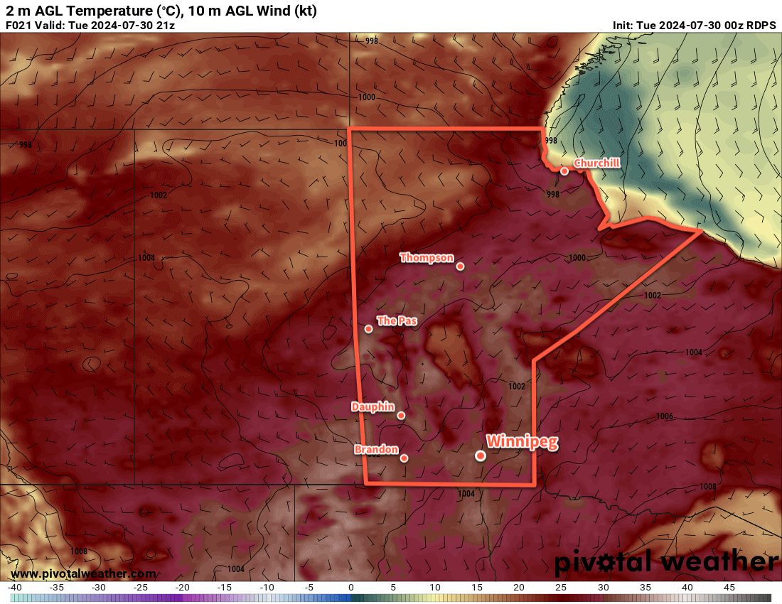
And what a day to get back at it. It will be a hot one in Winnipeg today as a low pressure system pushing into central Manitoba draws a hot air mass into the southern reaches of the province. Daytime highs will climb into the low 30s in the Red River Valley with muggy conditions as dew points climb back above 20 °C. The heat and humidity will combine to make it feel closer to 40 this afternoon.
Heading into the evening, a trough of low pressure will begin digging into this hot and humid air mass from the west. The environment over southern Manitoba will be primed for strong to severe thunderstorms. It will be an extremely unstable air mass characterized by MLCAPE values in excess of 2,500 J/kg and winds over the region will produce 20 to 30 knots of deep shear and be favourable for discrete supercell development. If any thunderstorms are able to develop along this trough, it is likely that they will quickly become severe thunderstorms capable of torrential rain, large hail, damaging wind gusts, and pose a low risk of a tornado.
All that said, though, it remains a low risk. By late in the day, a mid-level axis of warm air will be positioned over the region, and warm air aloft will work against the development of thunderstorms. With the potential potency of thunderstorm activity later today and its uncertainty, be sure to stay aware of any alerts that may be issued later today by the Meteorological Service of Canada.
If thunderstorms develop, the activity could persist into the overnight period, weakening as the night goes on.
Tomorrow will be another mainly sunny and hot day. The trough of low pressure will linger in the region, but much of the Red River Valley will sit west of it; this will give northwest winds to much of the region, bringing a slight easing of the humidity as dew points drop back into the upper teens. Daytime highs will climb back into the upper 20s with partly cloudy skies. There is a slight risk of a thunderstorm later in the day, but much of the instability will have shifted east and the likelihood looks low.
Thursday will bring sunny skies to the region as temperatures head back into the low 30s. The humidity will likely continue to ease, making for a less muggy day than the region will see today.
All three nights — tonight, Wednesday night, and Thursday night — will bring lows in the upper teens or low 20s and light winds.
Long Range Outlook
Friday will bring more heat and sunshine to the region with daytime highs near 30 °C, but with less humidity than seen through the earlier parts of the week. Sometime Friday night or early Saturday, a cold front will push through southern Manitoba and bring a chance of showers or thunderstorms. Behind it, conditions will settle and temperatures will return to seasonal values.
A stretch of seasonal temperatures is expected to persist through the weekend and into next week. This, unfortunately, could result in forest fire smoke from western Canada spreading into southern Manitoba. It’s too early to tell, but keep in mind that those cooler temperatures could come with degraded air quality.
Stay cool today, check on those you know who don’t have A/C, and have a good week!
Today’s seasonal daytime high in Winnipeg is 26 °C while the seasonal overnight low is 13 °C.
More rain will move through the Winnipeg area today, but a high pressure system will bring sunshine for the weekend.
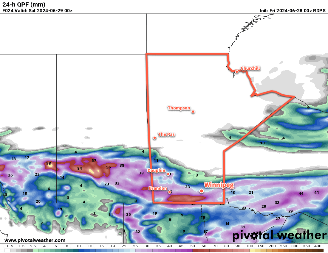
A low pressure system crossing the southern Prairies will leave behind a swath of moderate to heavy rainfall accumulations.
A low pressure system crossing the province today will bring unsettled conditions to the Winnipeg area. Rain moved into the region overnight and will continue as widespread rain and showers through the day today. Northeast winds up into the 40 to 50 km/h range will keep temperatures cooler with a high in the upper teens this afternoon.
The rain will begin to break up this evening as this system’s upper-level disturbance curls to the south into North Dakota. Temperatures will head down to a low near 10 °C with easing winds.
Storm-total rainfalls will likely reach 25 to 50 mm in many areas in southern Manitoba, including Winnipeg.
For the weekend, a broad area of high pressure will build across the Prairies. This will bring sunnier skies but cooler temperatures will linger across the region. High temperatures in Winnipeg will reach the upper teens or 20 °C on Saturday, then climb into the low 20s on Sunday. Winds will be northerly at around 20 km/h on Saturday and southerly with similar speeds on Sunday.
Long Range Outlook
Another low pressure system is forecast to eject across the Prairies later Sunday and could bring showers and thunderstorms to southern Manitoba on Sunday night. The wet weather could last into Monday as an area of broad rainfall or several waves of thunderstorms…it’s not clear yet which way the system will develop.
Unsettled conditions with possible showers will linger behind this system through Tuesday. After that, it looks like conditions will settle somewhat, but a low chance of pop-up showers will likely last through the week.
Today’s seasonal daytime high in Winnipeg is 25 °C while the seasonal overnight low is 12 °C.
The chance of showers and thunderstorms will keep coming back to the Winnipeg area as a couple more disturbances cross the region in the coming days.
Another round of showers and thunderstorms will move through southern Manitoba on Saturday.
After dodging thunderstorms yesterday that hovered in the sky to the west and north of Winnipeg much of yesterday, the city will see a pleasant end to the work week. A broad area of high pressure will sit over the region and bring sunshine and warm temperatures to the city. After a sunny start to the day, skies will turn partly cloudy as daytime highs climb into the mid-20s this afternoon.
Temperatures will head down into the mid-teens tonight with partly cloudy skies.
On Saturday, the region will see increasing cloud as a disturbance moves into Manitoba from Saskatchewan. While showers and thunderstorms will be possible over west and southwest Manitoba through the day, the wet weather will likely hold off until later in the day for the Red River Valley. By late afternoon, scattered showers and thunderstorms will likely drift southeast through the region, with rain likely in the Winnipeg area.
There isn’t likely a widespread severe weather threat on Saturday for Winnipeg. The instability and wind shear required to organize a thunderstorm will be limited and while a strong thunderstorm is possible, severe weather is unlikely. The chance of showers and thunderstorms will persist into the evening, then taper off overnight.
Temperatures will climb back into the 20 to 25 °C range on Saturday, then dip back down into the mid-teens on Saturday night with cloudier skies.
Sunday will bring another ridge of high pressure through the region. This should clear the clouds out for a sunny afternoon with a high back in the mid-20s. The region will have northerly winds up to the 20 to 30 km/h range. Temperatures will head back down to the mid-teens on Sunday night with partly cloudy skies.
Long Range Outlook
Another low pressure system will move through the region on Monday, bringing another chance of showers and thunderstorms to the Winnipeg area. After that, there is a chance that the region could see stabler conditions for the rest of the week with near-seasonal temperatures.
Today’s seasonal daytime high in Winnipeg is 24 °C while the seasonal overnight low is 12 °C.