April Off To A Cool Start

There’s no joke here; April will be off to a cool start as a surge of Arctic air moves into Southern Manitoba today, bringing temperatures 5-10°C below normal to the region through the weekend.

Today will bring a potent little low pressure system that will spread cloud into Winnipeg & the Red River Valley through the morning as it approaches from the northwest. Temperatures will climb to a high near 0°C as snow moves into the region through the afternoon. The bulk of the snow will fall through the late afternoon and early evening, with around 2-4cm expected across the region.

Behind the low pressure system, a cold front surges southwards and very strong northerly winds are expected to move through the Red River Valley, with the strongest winds occurring between around 9PM and 2AM. The winds will peak with sustained winds of 50-60km/h and gusts as high as 80km/h. As the winds taper off overnight, skies will clear and temperatures will drop to a low near -9°C.
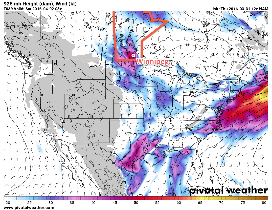
NAM Forecast 925mb Winds – 03Z April 2, 2016
A core of very strong winds is expected over the Red River Valley on Friday evening.

Saturday will be a calmer day that acts as a brief reprieve while the next low pressure system organizes over the western Prairies. The day will start off fairly sunny, but more cloud will begin moving in from the northwest through the afternoon as the next system begins approaching the province. Daytime highs will sit near -1°C with light winds. Temperatures will fall to around -6°C on Saturday night with some light snow building into the region. Winds will pick up out of the east through the night.

Sunday will bring some more snow to the region as the next low passes through. The organized snowfall will taper off through the morning then diminish to some flurries through Sunday afternoon. Daytime highs will be near 0°C with winds shifting to the north through the afternoon.
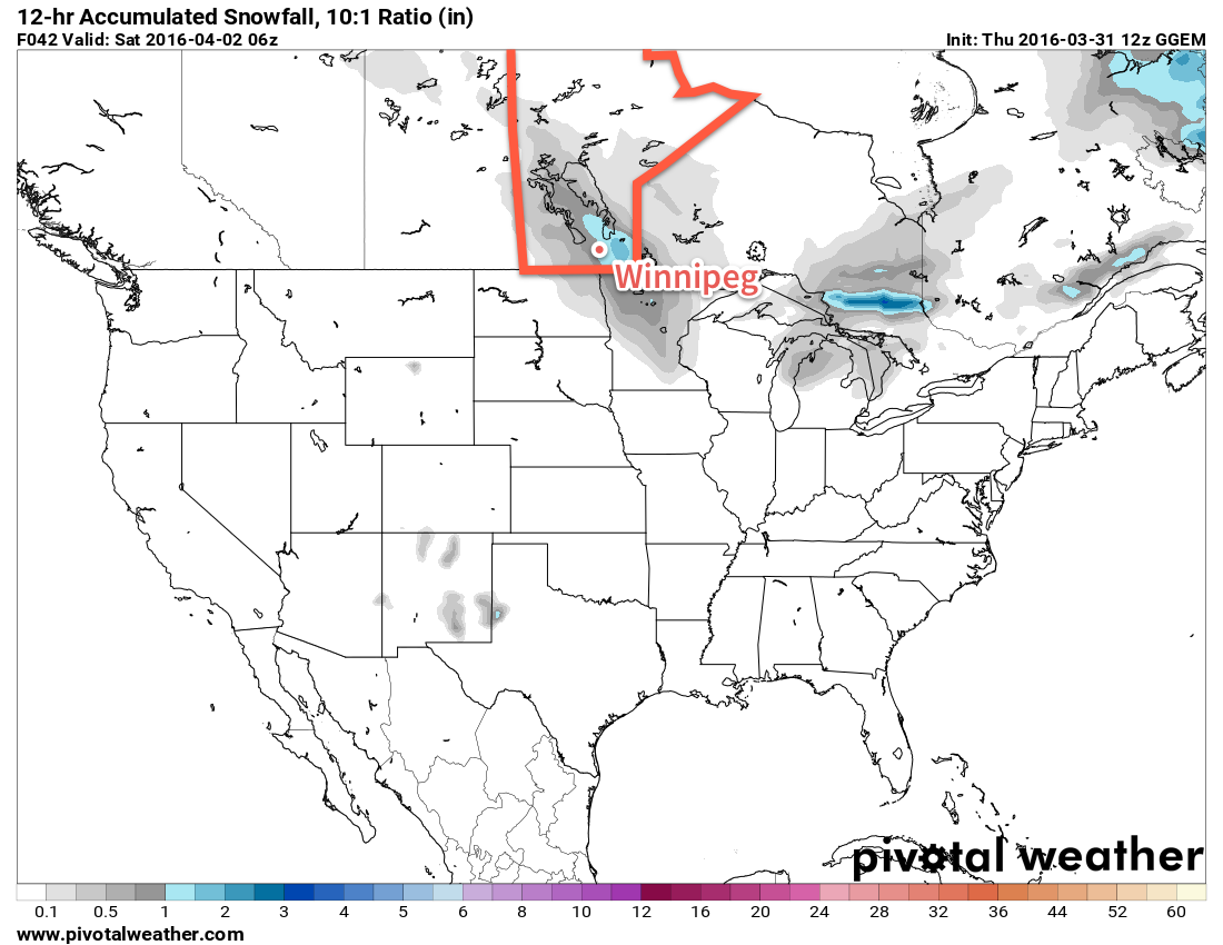
GDPS 12hr. Snowfall Forecast (10:1 SLR) valid 06Z April 2, 2016
A swath of 2-4cm of snow is expected across south-central and south-eastern Manitoba later today.

By the time all is said and done, it looks like this second system will produce another 2-4cm of snow in Winnipeg, however some models hint at some more intense snowfall possible with this system; we’ll keep an eye on it as it develops. Skies will clear out on Sunday night with temperatures dropping to -9°C or so on Sunday night.

Long Range

Temperatures will continue below-normal into the start of next week. The biggest story, though, is the chance for a major winter storm early next week.
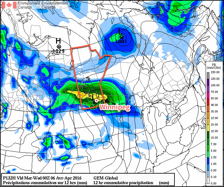
GDPS 12hr. QPF Forecast valid 00Z April 6, 2016
The GDPS is showing a major winter storm on Tuesday

Several models are picking up on a storm system moving through Southern Manitoba on Tuesday that will bring windy conditions alongside the potential for 10-20cm of snow. It’s too early to get into many specifics but this system would bring rain, freezing rain and snow into the province. We’ll be keeping an eye on this one and have more details in Monday’s forecast!

Winnipeg’s seasonal daytime high is currently 5°C while the seasonal overnight low is -6°C.
Arctic Blast Incoming

A major shift in the overall weather pattern will bring a blast of Arctic air to Winnipeg for the end of the week, ushered in by unpleasant and strong northerly winds and the now-infamous Polar Vortex. Fortunately, the cold snap looks to be short-lived as the coldest air will rotate off towards Eastern Canada quickly and near-seasonal temperatures return early next week.

Today will remain pleasant with above-seasonal warmth in place as temperatures climb to around the 9°C mark for Winnipeg’s daytime high. Skies will start off sunny, but become mixed through the afternoon as cloud begins spreading in ahead of a low pressure system that will impact the province later today and tomorrow. Showers and flurries will push into western Manitoba this afternoon, but will remain west of the Red River Valley for the most part until tomorrow.

Here in Winnipeg, skies will be cloudy tonight as the temperature drops to a low near 0°C.

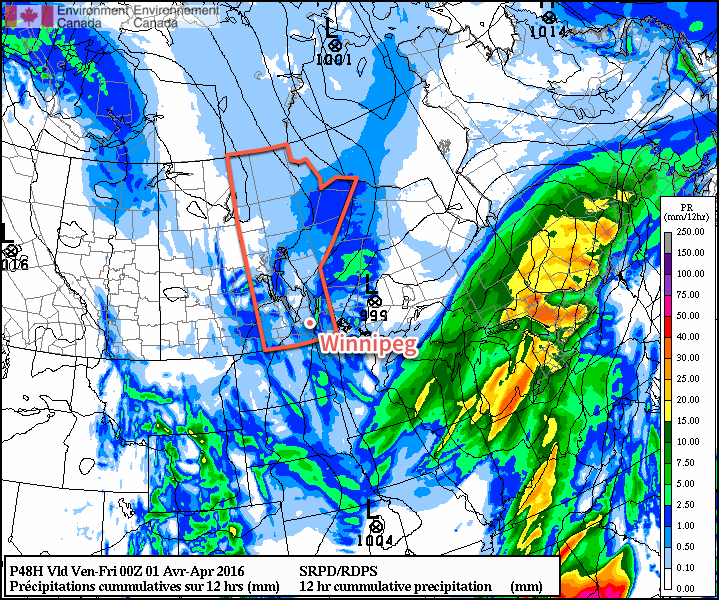
RDPS 12hr. precipitation forecast valid 00Z Friday April 1, 2016
Scattered showers and flurries are expected across Southern Manitoba on Thursday

Thursday will be mainly cloudy with a chance of showers or flurries throughout much of the day. The first of two cold fronts will swing through in the afternoon, ushering in strong northerly winds of 40 gusting 60 km/h. Temperatures will climb to 4-5°C for the daytime high, but much cooler air will work into the region tonight, sending overnight lows to around -8°C.

Friday will also bring cloudy skies with a high near +2°C as another low pressure system moves through brining a decent chance for some more snowfall through the afternoon/evening. Behind the system, another shot of strong northerly winds, this time as strong as 50 gusting to 70 km/h. Temperatures will fall to a low near -10°C on Friday night.

Long Range

The weekend will be cool with below-normal temperatures as the Polar Vortex grazes Manitoba as it rotates eastwards into Ontario.

The Polar Vortex is easily seen by abnormal 500 mb heights (pictured above over Ontario in pink/purple) and will bring below-normal temperatures to much of Manitoba throughout the weekend with daytime highs near the freezing mark. Alongside the cool weather will also come mainly cloudy skies, but no precipitation is expected.

Temperatures will rebound back towards seasonal next week with precipitation confined to a weak disturbance mid-week that could potentially bring a couple cm of snow or few mm of rain, depending on temperatures & timing.

Winnipeg’s seasonal daytime high is currently 5°C while the seasonal overnight low is -6°C.

Mild Early Week Weather

The weather this week will start out mild, with temperatures in the mid to upper single digits. However, cooler conditions are on the way later in the week, so enjoy it while it lasts!

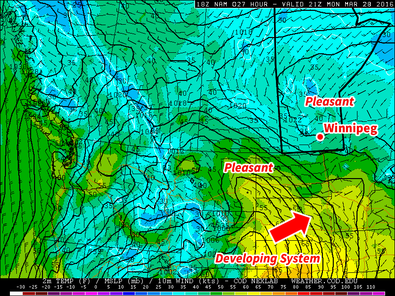
Today will be pleasant, with temperatures in the mid to upper single digits over southern Manitoba. Skies will remain mainly sunny, with generally just some upper-level cloud cover passing through. Winds will be easterly at about 20 km/h.

Pleasant conditions are expected early this week in southern Manitoba

Tuesday will remain mild, with temperatures once again in the mid to upper single digits. A weak disturbance will bring a chance of flurries or showers to southern Manitoba; no significant accumulations are expected, but it will be a drearier day. To our south a much stronger system will be passing through the central US Plains, but it is not expected to significantly affect southern Manitoba. Winds will be northerly at 20-30 km/h.

Wednesday will be slightly cooler than temperatures earlier in the week, with highs in the mid single digits. Skies are expected to turn mainly sunny again though, making for a generally nice day. Winds will be northerly at about 20 km/h.

Long Range

The long range forecast is a bit uncertain at this time, but overall it doesn’t look great. Models suggest that a much colder air mass will surge down from the north late this week, bringing with it below seasonal temperatures. This colder pattern is expected to stay with us as we move into early April.

Mixed Bag Ahead

A mixed bag of weather lies ahead with some cloudy & cool conditions transitioning to milder weather with variable cloudiness and a chance of showers.

Today will be a rather cool day with a below-seasonal high temperature of just -1°C as last night’s snow pushes out of the region while a ridge of high pressure builds in behind, bringing moderate northerly winds of 30 gusting to 50 km/h. Much of the day will be mainly cloudy, but by the afternoon, clearing should begin working into the Red River Valley from the north.

Tonight will bring mainly clear skies and an overnight low near -10°C while the northerly winds gradually taper off overnight.

Saturday will bring plenty of sunshine to the region with just a few clouds and light winds. Temperatures will climb to a near-seasonal daytime high of +1°C. Saturday night will see an overnight low near -5°C with increasing cloud through the second half of the night as a weak disturbance moves towards the region from the northwest.

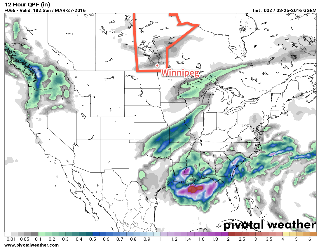
GDPS 12hr. QPF valid 18Z Sunday March 27, 2016
This 12-hour precipitation accumulation valid mid-day Sunday shows weak showers and flurries moving through Manitoba

A chance for showers will return to the region on Sunday as a weak low pressure system brings mainly cloudy skies to Winnipeg and the Red River Valley. Temperatures will climb to around 5°C for a daytime high with winds out of the south near 20 km/h. Skies will remain fairly cloudy on Sunday night with a low near -4°C.

Long Range

A quick look ahead to next week shows milder weather with daytime highs in the mid-to-upper single digits through the first half of the week, but then an abrupt shift back to below-normal temperatures after a major low pressure system moves through the United States mid-week.

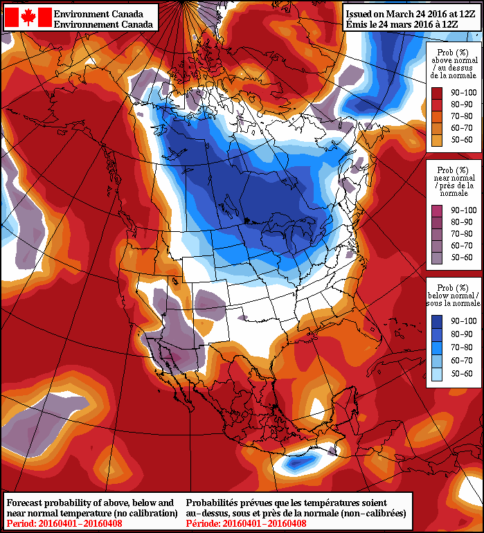
NAEFS 8-14 Day Temperature Anomaly Forecast — Valid April 1 - April 8, 2016
NAEFS 8-14 Day Temperature Anomaly Forecast — Valid April 1 – April 8, 2016

As the NAEFS image shows, for April 1st through April 8th, there’s a near-certainty of seeing below-normal temperatures in Southern Manitoba. At this point, it looks like this will translate to daytime highs near or just below 0°C.

No significant precipitation is expected next week, at least for now. If the track of next week’s major low changes and it shifts further north, well that could be a completely different story!

Winnipeg’s seasonal daytime high is currently 2°C while the seasonal overnight low is -8°C.