Seasonal Temperatures & Occasional Snow

Near-seasonal temperatures are on the way for Winnipeg through the remainder of this week with multiple chances for light snow as several weak disturbances slide across the region.

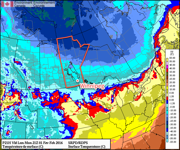
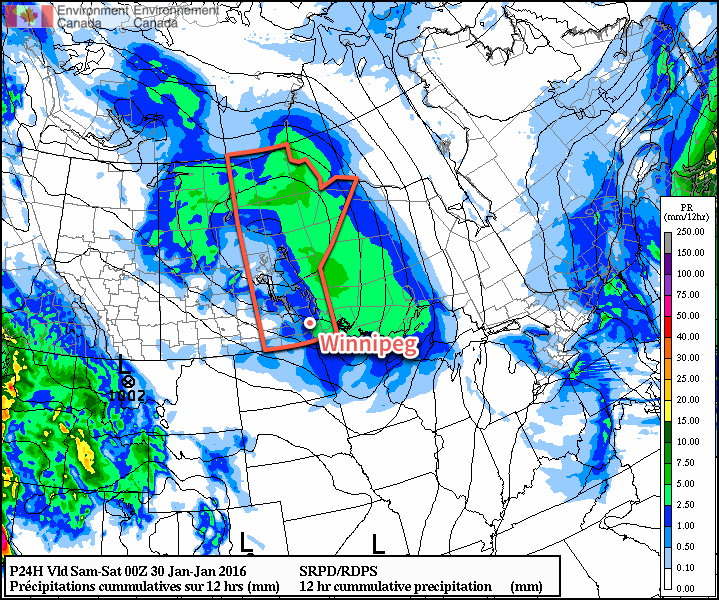
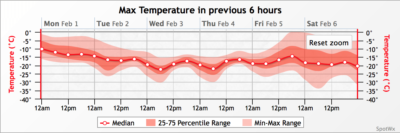
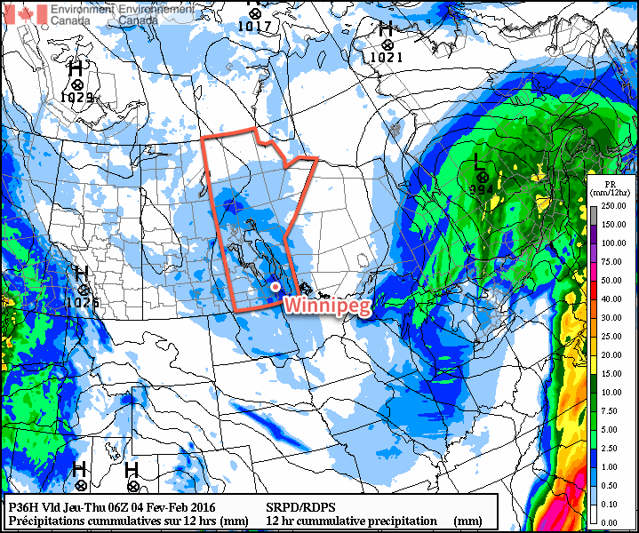
Today’s weather will be dictated by a weak low pressure system moving through the region that will spread more cloud and snow across Southern Manitoba. Although the snow will be widespread as it gradually pushes eastwards across the province, it will also be quite light. The grand-total for around 4-6 hours of snow will be just 1-2 cm, with some areas that see little-to-no accumulation. Here in Winnipeg, we’ll see some sun through the morning, then increasing cloud with some light snow starting late in the afternoon. It will be pleasant for early February, however, with daytime highs around -11°C and light winds. Expect temperatures to dip to around -15°C tonight under mainly cloudy skies.

RDPS-based precipitation forecast valid from 18Z - 06Z February 3/4, 2016
RDPS-based precipitation forecast showing snow over Manitoba through Wednesday afternoon & evening

Thursday will be a benign day with mainly cloudy skies, daytime highs once again near -11°C for Winnipeg, and light winds. There’s a very slight chance of some flurries thanks to the temperature profiles through the lower atmosphere, but if they do develop, they will be quite weak. Temperatures will drop to about -14°C on Thursday night with cloudy skies as the next low pressure system moves in from the west.

Friday will be another cloudy day with daytime highs climbing a couple degrees higher to around -9°C. There’s a decent chance of some flurry activity through the Red River Valley as the next low pressure system tracks through the region. Temperatures will dip to around -14°C on Friday night under cloudy skies.

Long Range

The long-range outlook shows a fairly significant pattern change next week, but not before things turn a little more unsettled.

Through the weekend and into the first half of next week, the weather looks to turn more unsettled as the storm track shifts over Manitoba. No major snowfalls are expected at this point, but several relatively strong lows will likely move through the region, at least bringing a little more variability to the temperature and some windy conditions at times.

GFS-based forecast of 850mb temperature anomalies for the end of next week

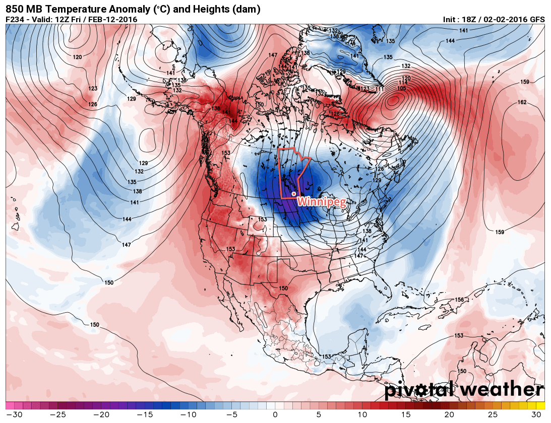
A major large-scale pattern change begins early next week as the polar vortex slumps southwards into Northern Ontario as large scale upper-level ridging takes place over the west coast of North America. This combination will shift winds at all levels over Manitoba to northerlies straight out of the Arctic, and a surge of colder air will blast southwards in response. This will likely happen in multiple stages with a weaker shot mid-week and then a stronger surge at the end of the week. The image above shows the GFS forecasting 850mb temperatures [1] over 10°C below normal for next Friday.

If this forecast comes to fruition, then through the latter half of next week daytime highs would fall into the -15 to -20°C range.

The colder air doesn’t appear to be likely to stick around for too long, though, with seasonal temperatures building back in by the end of the weekend.

Seasonal daytime highs in Winnipeg for early February are -10°C while seasonal the overnight lows are -21°C.


  1. 850mb is approximately 1.5km above the ground.  ↩

Seasonal Conditions Early This Week

This week will start out with near seasonal conditions as temperatures stick near the -10C mark.

Today will see temperatures around or just above -10C. Skies will be mainly cloudy with a chance of flurries as a weak system passes to our south. Given the slack pressure gradient over southern Manitoba, winds will remain light and variable.

Tuesday will be slightly cooler than Monday, with temperatures around or just below -10C. An arctic air mass to the north will continue gradually sliding southward, allowing slightly colder weather to prevail. The drying associated with this colder air mass is expected to help clear skies a bit, although it looks like we won’t see completely sunny skies, but rather a mix of sun and cloud. Winds will be north-westerly at about 20km/h.

RDPS Temperature Forecast valid Monday afternoon
Forecast temperatures mid-afternoon across the Prairies on Monday

Wednesday will remain near seasonal, with temperatures once again just below -10C. Skies will become cloudy again as an upper-level impulse moves through the region. This impulse may bring a few flurries to southern Manitoba, but nothing significant. Winds will shift to southerly at around 20km/h.

Long Range

Models still aren’t showing a strong signal for what the long range forecast may entail. Based on the trends in the guidance, it looks more probable that February will cooler than normal than warmer than normal, but that is just an educated guess at this point.

Mild Weekend Then Into A Colder Stretch

A low pressure system crossing the Prairies will bring another wave of unseasonably mild air into Southern Manitoba and help temperatures climb above 0°C for the second time this week. Heading into the latter half of the weekend, unsettled weather will develop over Southern Manitoba bringing flurries as cooler air begins gradually slumping southwards out of the Arctic and across the Prairies.

Today will be a much nicer day for Winnipeg than it appeared like it would be earlier this week, all thanks to a more northern track for today’s low pressure system crossing the province. As a result of this trajectory, Winnipeg will still see the warmth we expected before, but much less of the precipitation, which will now mainly fall through Central Manitoba and the Interlake before heading off into Ontario.

For the city, today will start off with a chance of…well, just about anything—snow, freezing rain, or showers—as a warm front pushes through and brings our temperatures above zero. As the warm front pushes off to the east relatively early in the day, we’ll be left with skies on the cloudier side and temperatures in the +1-2°C range. Windswe will start out of the south at around 30-40km/h before shifting to westerly behind the warm front at similar speeds. The chance for showers will redevelop mid-day and through the afternoon as a little bit of cooling aloft moves across the region. Expect temperatures to drop to around -2°C tonight with a few clear breaks developing.

RDPS 12hr. QPF Forecast for Friday January 29, 2016
This RDPS forecast showing accumulated precipitation through Friday shows how most of the precipitation is expected to our north and east

Saturday will bring more warm weather cloudier skies once again, although a few sunny breaks are certainly possible and the southwestern Red River Valley may actually end up seeing a fair amount of sunshine. Temperatures will climb to around +1°C with lighter winds than Friday.

A cold front will begin slumping southwards through the region on Saturday night. This will bring cooler temperatures and send our overnight low down to around -11 or -12°C under cloudy skies. Alongside the cooling will be a chance of some light flurry activity.

Sunday will be a cooler day with a high in the near -6°C or so. Under mainly cloudy skies, Winnipeg will see a slight chance for flurries throughout the day thanks to favourable temperatures throughout the lower atmosphere. This cooler weather will mark the leading edge of a return to seasonal and below-seasonal temperatures for a short while.

Long Range: Colder, But For How Long?

Looking forward into next week, it looks like cooler weather will return to the Prairies as the conditions that have supplied the warmer weather to the region over the past week collapse southwards and allow cooler Arctic air to slump southwards.

GEPS Maximum Temperature Forecast valid February 1-6, 2016
GEPS maximum temperature forecasts valid for the February 1-6, 2016 time period

The GEPS[1] is showing a transition into slightly below normal conditions next week. This image shows the maximum temperature expected in each 6-hour time period from Monday through Saturday. Ensemble forecast systems produce numerous forecasts, and then statistical analysis can be done on the output to (in theory) produce more accurate forecasts, especially in the long range. In the image above, the easiest way to understand it is that the value along the line is a fairly reasonable "most likely" temperature, while the red shading on either line represents the certainty; if there’s little shading extending from the line that means there is high confidence in the values; if there’s a lot of shading extending above and below the line, it means that there’s more uncertainty associated with the forecast at that time.

The GEPS shows fairly reasonable confidence that daytime highs will be dropping into the -15 to -20°C range early next week, a fair amount below the seasonal highs of -11°C for this time of year. With daytime highs in that range, it’s likely overnight lows will dip into the mid-minus 20’s. Heading toward the end of the week, though, there begins to be a lot more uncertainty on the weather pattern, so we’ll just have to wait and see for when the warm-up returns!


  1. Global Ensemble Prediction System  ↩

Messy Wednesday Morning Leads to Wind & Warmth

Winnipeg will likely see a messy commute on Wednesday morning as a warm front pushes through and brings the potential for some rather intense snow. Behind the front, however, gusty westerly winds will bring very mild weather to the province with temperatures climbing above freezing. This transition will lead into a fairly warm spell that will persist throughout the remainder of the week as multiple disturbances roll through the region.

Snow & Freezing Rain Ahead of Milder Weather

The weather on Wednesday morning will be dominated by a low pressure system and associated warm front that will push through the province Wednesday morning, bringing with it snow, freezing rain and rain to the province. Over western & southwestern Manitoba, precipitation will be a wintery mix of rain, freezing rain and snow. The freezing rain may be fairly intense at times, with total ice accumulations of 2-3mm possible. This will be more than enough to make regional highways treacherous. The freezing rain threat will extend slightly into the southwestern Red River Valley, but will depend significantly on the exact low-level temperature profiles and track of this system. Anyone southwest of Winnipeg in the Red River Valley should stay alert of the potential expansion of freezing rain warnings eastwards.

While light freezing rain is possible throughout the remainder of the Red River Valley, it’s far more likely that the precipitation will fall as snow. To the east of the main band of freezing rain, a swath of fairly intense snow will slump southeastwards overnight and move into the Red River Valley in the morning.

Forecast Sounding for Winnipeg – Wednesday January 27 @ 1400Z
Forecast sounding for Winnipeg early Wednesday morning

This forecast sounding, which shows the forecasted temperature and moisture profile as you move upwards in the atmosphere, is rather telling regarding heavy snowfall:

  1. First is that there is a deep, deep layer of saturation (shown by the red and green lines being close together. Essentially the entire tropopause is forecasted to be saturated with ample synoptic lift moving in. This will provide plenty of moisture for snow generation.
  2. Also revealing is the moist adiabatic profile[1] throughout the mid-to-upper levels of the atmosphere coupled with the cooler advection occurring aloft. This is a fairly traditional profile that often produces widespread embedded convection within the precipitation area.

These two aspects reveal that intense bursts of snow will be likely with this system, resulting in abruptly reduced visibilities and rapid accumulations. The bulk of the snow is expected to fall between 6 and 9AM, with total amounts of 5-10cm possible in Winnipeg and much of the remainder of the Red River Valley. This will likely result in significant delays in the morning commute as drivers battle slippery roads and poor visibility.

The snow will taper off to flurries for the remainder of the morning and then the next phase of the system sets in…

Mild Weather, But Questionably Nice

Behind the warm front, temperatures will continue to climb in Winnipeg to a daytime high of around 2°C as gustier west-northwest to northwest winds move in. The winds will likely climb all the way to around 40-50km/h, making for not exactly pleasant outside weather. As we climb above 0°C, depending on a few different things, the flurries may either stop or transition to some isolated rain showers.

Heading into the evening, the new dominant weather feature will be a very slow-moving cold front gradually slumping southwards through the province. With ample moisture stuck in place and temperatures dropping back below zero, fog and drizzle/freezing drizzle will begin to become a concern. At this point, it looks like the winds will begin to taper off through the evening, becoming relatively light by midnight or so. Once the winds ease, it’s quite likely cloud bases will begin lowering throughout the region with the risk of fog or drizzle developing. The overnight low will sit around -5°C, so if drizzle materializes, it will do so as freezing drizzle.

Thursday will see the Winnipeg and much of the region stuck underneath that pokey front as it begins to stall and push back to the northeast as the next low pressure system begins developing over the western Prairies. Skies will remain mainly cloudy as a slack flow combines with the weak convergence aloft around the front to keep the moisture socked in over the region. With all that low-level moisture stuck in place, the risk for freezing drizzle and/or fog will also continue. Winds will be fairly light and the high will be around -4°C.

GDPS 6hr. QPF divided by precipitation type.
The GDPS model shows a mix of rain, snow and freezing rain over Southern Manitoba late Thursady night.

The next weather system will begin moving in on Thursday night, spreading warmer air eastwards. As a result, temperatures will climb to around -2°C by Friday morning alongside some light snow and a threat of another round of freezing rain, this one primarily for the Red River Valley.

Winter Mix for Friday

Friday will be another mild day with temperatures climbing to +1 or +2°C in the warm sector of the second disturbance impacting us this week. Freezing rain or snow will taper off to cloudy conditions with a chance of some drizzle. At this point there’s wide discrepancies in how much precipitation will fall through Thursday night and Friday morning, with everything from a relatively minor event to a chance for another 5-10cm of snow.

Late in the day as temperatures cool slightly, some lighter snow is possible. Temperatures will drop to around -1°C on Friday night.

Normal daytime highs for Winnipeg at this time of year currently sit at -12°C with typical overnight lows near -22°C.


  1. Moist adiabatic is the "temperature path"—how its temperature changes—that an imaginary parcel of air will follow as it moves up and down in the atmosphere if it is saturated.  ↩