The weather this week will remain well above seasonal with high temperatures generally in the minus single digits.
Today will be mainly cloudy with a good chance of flurries as a strong upper-level disturbance passes through southern Manitoba. No significant accumulations of snow are expected. Temperatures will be in the mid minus single digits with north-westerly winds at 20-30km/h.
Skies should clear on Tuesday as a drying north-west flow persists over the region. Temperatures will be slightly cooler than Monday, but still in the minus single digits. Winds will generally be light and variable.
A strong low pressure system will be the focus of Wednesday’s weather in southern Manitoba. A warm front will pass through during the day, bringing with it a small, but heavy band of snowfall. Given the warmth of the air associated with this front, there is a chance of some mixed phase precipitation in some areas, but it’s too early to discuss those details. It appears that 2-4 cm of snow is probable with this system, but again that total should be revisited closer to the event.
Long Range
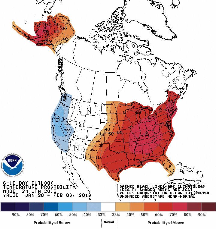
The CPC’s 6-10 day temperature anomaly forecast shows a strong return to El Nino winter conditions.
In the longer range it appears we’ll see above-seasonal weather last for the rest of the week before more normal weather returns next week. Long range models aren’t showing a clear signal for February’s weather at this time, which suggests fluctuations between above and below normal conditions.
Warmer weather is on the way for the weekend with temperatures soaring close to the freezing mark, however not before a blustery day that will be rather miserable and may impact transportation throughout the Red River Valley.
Windy Weather Developing
Windy weather is on the way for Winnipeg today courtesy a developing low pressure system pushing eastwards across the Prairies. As this system moves towards Manitoba, a strong pressure gradient will develop over the Red River Valley between the incoming low pressure centre and departing ridge of high pressure. As the gradient strengthens in the afternoon, strong southerly winds will develop throughout the Red River Valley.
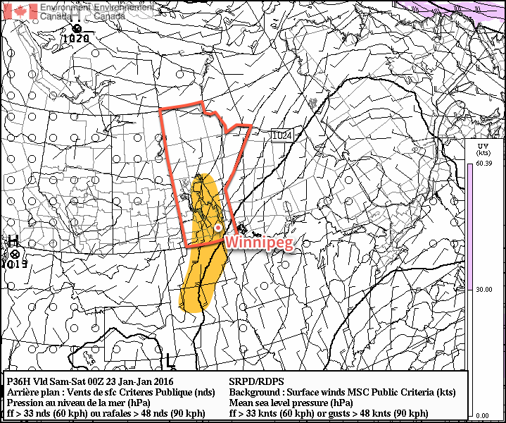
Strong winds are expected by Friday evening through Southern Manitoba and the Northern Plains (the highlighted area).
Sustained wind speeds will increase to 40-50 km/h by the early evening. It seems fairly probable given the near-constant light snow and ice crystals that have fallen over the last several days that blowing snow will become a transportation issue for Friday night into Saturday morning. In Winnipeg it shouldn’t be too bad, but in rural areas, particularly along west-east running highways, the potential for near-whiteout conditions exists. Be sure to give yourself extra time and carry a winter survival kit if you will be travelling on area highways.
Warmer Weather Brings Risk for Freezing Rain or Drizzle
Winds will begin tapering off on Saturday morning as the low pressure system arrives, bringing with it a blast of mild Pacific air. Despite the fact that skies will remain cloudy for most of the day, temperatures will soar to a high of -1°C.
Alongside the surge of warm air will come a risk of some freezing rain. An above-freezing level (AFL) will develop overnight, and by morning an area of precipitation is expected to slide through Parkland Manitoba, the Interlake and northern Red River Valley before sliding eastwards into Northern Ontario.
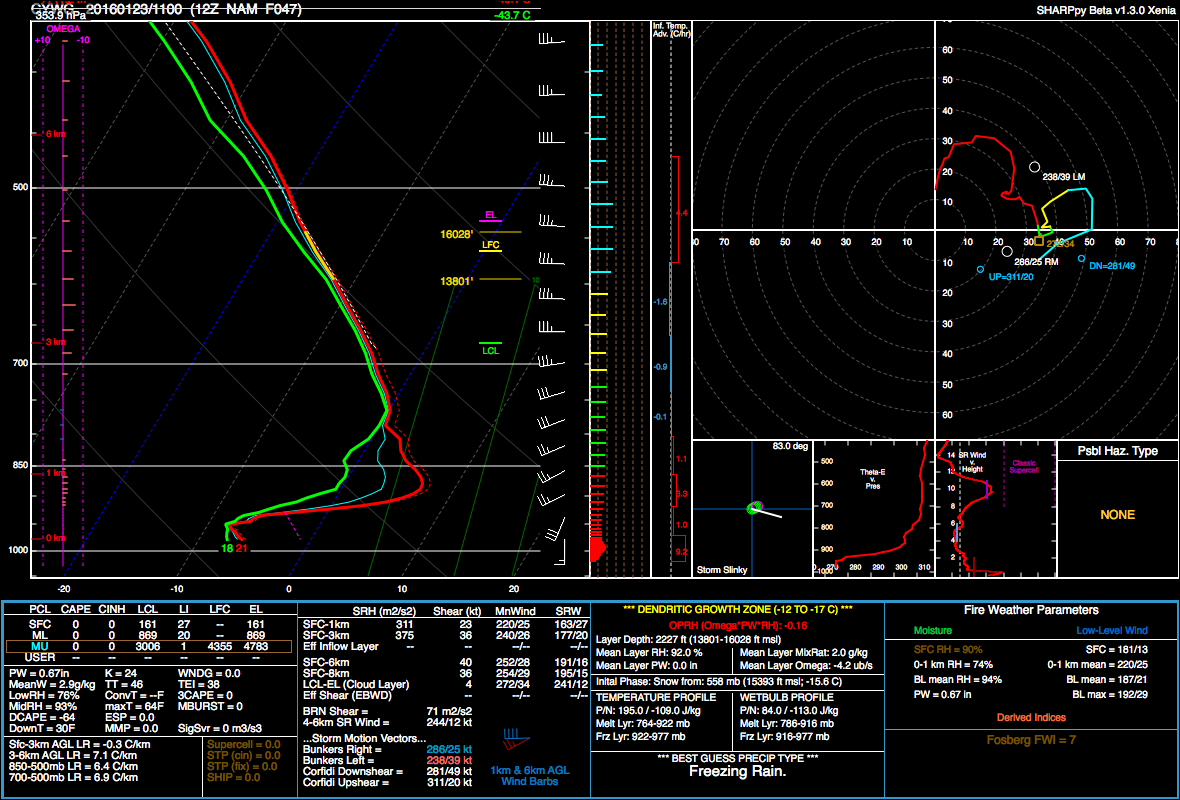
This forecast sounding for Winnipeg from the NAM shows a well-defined AFL with Tw ≥ 0°C.
With sustained warm air advection and a wet-bulb temperature above 0°C in the AFL, the potential for organized freezing rain exists. The highest likelihood lies over the Swan River region and then southeastwards through the Interlake. The risk exists over the Red River Valley, but at this point it doesn’t appear that actual amounts will be particularly high. Nonetheless, it doesn’t take much freezing rain to make things slick, so we’ll monitor things and provide an update if the threat for the Red River Valley increases.
Behind the warm front, freezing drizzle will be possible throughout much of the day with saturated low-levels and the lift associated with the incoming low. Winds will be calm through the afternoon.
Winds will shift to the northwest in the evening as a cold front passes through. Skies will remain fairly cloudy and the threat for freezing drizzle will persist well behind the cold front and through much of the night. Temperatures will drop to around -8°C by Sunday morning.
Sunday will bring weak cold air advection through the day, resulting in temperatures rebounding only slightly if at all through the day. The chance for flurries will redevelop as temperature profiles become too cold for freezing drizzle and more favourable for snow. That said, overall moisture supply will be dwindling, so at this point it appears that there will be just a chance for some flurries.
Sunday night will bring cloudy skies and a low near -10°C.
Welcome to A Weather Moment’s look back at the weather in Winnipeg for 2015. In this update, we’re going to take a look at how temperature & precipitation developed through the year and how 2015 stacked up against the history books. In another post coming soon, we’ll take a look at the top 10 weather events of 2015!
2015 Stats & Rankings for Winnipeg
Category
2015 Average or Total
Rank (since 1873)
High Temperature
10.1°C
7th warmest (tie)
Mean Temperature
4.2°C
9th warmest
Low Temperature
-1.7°C
11th warmest (tie)
Rainfall
450.9 mm
38th rainiest
Snowfall
116.7 cm
64th least snowy
Precipitation
529.6 mm
61st wettest
Temperature: Chilly Start With A Mild Finish
With a mean temperature of 4.2°C at the Winnipeg International Airpot, 2015 was the 9th warmest year on record since 1873 in Winnipeg and the warmest since 2012. This was 1.3°C warmer than the 1981-2010 normal of 2.9°C. In addition, daily high temperatures averaged 10.1°C, only the 9th time since 1873 that this value was in the double digits. The graph below shows how each month fared compared to normal and how the year-to-date average changed throughout the year.
Only three months were colder than the 1981-2010 normals: February (-5.7°C), May (-0.4°C) and August (-0.2°C). February was by far the most abnormally cold month, averaging -19.2°C, 5.7°C below normal and the 27th coldest February since 1873. It was also the 3rd coldest February since 1980 and the 11th coldest February in the last century. Only 6 days rose above -10°C, tied 10th least since 1873. Interestingly, it was the 10th colder than normal February in the last 11 years.
Six months in 2015 averaged over 2°C above normal: December (+5.4°C), November (+3.7°C), September (+2.9°C), March (+2.8°C), January (+2.7°C) and October (+2.0°C). There was a streak of four months averaging over 2°C at the end of the year. In fact, the September to December period was the third warmest on record since 1872 with an average of 3.5°C. Only 1931 (avg 4.1°C) and 1923 (avg 3.7°C) were warmer. The 1981-2010 normal is 0.0°C.
Top 10 Warmest Years in Winnipeg (Since 1873)
Rank
Average Mean Temperature
Year
1
5.4°C
1987
2
5.3°C
1931
3
4.7°C
1878 & 1998
5
4.6°C
2012
6
4.5°C
2006
7
4.4°C
1981
8
4.3°C
1999
9
4.2°C
2015
10
4.1°C
2010
Other stats included:
12 days above 30°C at the airport (normal is 14 days) and 16 days at The Forks
45 days below -20°C at the airport (normal is 53 days) and 33 days at The Forks
3 new record highs (13.2°C on Mar 14, 24.8°C on Apr 15 and 5.6°C on Dec 9) and 3 new record high minimums (21.2°C on Aug 15, 21.0°C on Sep 3 and 5.3°C on Nov 16)
NO new record lows or low maximums in 2015
Precipitation: Highly Variable & Above Normal
2015 was a wet year in the Red River Valley. In Winnipeg, 450.9 mm of rain fell at the airport, about 23 mm above normal. This was on the low end of things because many stations inside the city received over 500 mm. 544.0 mm of rain fell in south St. Vital, the rainiest year since 2010. August was the rainiest month with 148.8 mm in Charleswood, 140.5 mm in south St. Vital and 107.8 mm at the airport. The rainiest day of the year in the south end was August 22 with 68.8 mm in Charleswood and 54.5 mm in south St. Vital. September 4 was the airport’s rainiest day with 41.1 mm. These rainy days were the consequence of heavy thunderstorms.
In terms of snowfall, generally 115 to 120 cm or so fell in Winnipeg. This is basically bang on normal. More than a third of this snow fell in December with 44.0 cm, the 12th snowiest December on record since 1872. In fact, about 40 cm fell in just 8 days from December 16 to 23.
Combining rainfall with melted snowfall gives a total precipitation amount for the year. About 530 mm fell in Winnipeg officially, which is within a few mm of normal (note that I use The Forks station in the winter months and the airport station in the warmer months because the airport station underestimates winter precipitation). Again, most parts of the Red River Valley saw much more. 632.3 mm of precipitation fell in south St. Vital, about 80 mm more than in 2014 and the most since 2010. Widespread totals over 600 mm occurred south and southeast of the city. Locally over 700 mm was recorded at some CoCoRaHS stations in the Steinbach area. The higher totals were seen in areas that were hardest hit by heavy thunderstorms over the summer.
Other stats included:
3 new record high rainfalls (31.3 mm on May 17, 38.4 mm on Aug 22 and 41.1mm on Sep 4)
1 new record high snowfall (18.0 cm on Dec 16)
Wrapping Up 2015
Overall, it was a very warm and wet year in the Red River Valley.
The 30-year normal temperature in Winnipeg now stands at 3.0°C (1986-2015 period), tied with the 1984-2013 period for warmest 30-year period since 1872. This means we are currently the warmest we have been in at least 140 years.
It was also an active year for thunderstorms across southern Manitoba with numerous severe hail and tornado events. Stay tuned over the next couple weeks for the top 10 events and stories of the year which will summarize the biggest extremes we saw in 2015.
Winnipeg will see near-seasonal temperatures over the coming days with some light flurry activity mixed in before a big warm-up moves in for the weekend. The transition to warmer weather won’t be particularly graceful, however, as a howling southerly wind develops on Friday, making for a rather unpleasant shift.
The weather in Winnipeg through today and tomorrow will be dominated by the gradual arrival of a weak Arctic high that will slowly build southeastwards out of the Northwest Territories across Saskatchewan and Manitoba. Weak is the key descriptor of this ridge; it will bring with it little in the way of cold air nor will it be able to muster up much clearing either.
That said, today’s weather will be relatively pleasant, all things considered. Skies will be mainly cloudy through the day with some occasional light flurry activity. Temperatures will climb a little bit from where we start off to about -10°C with fairly light winds throughout the day. Tonight will continue to bring mainly cloudy skies—although a few clear breaks are possible—and temperatures dipping down to about -18 or -19°C. If more clearing develops than is expected at this point, the overnight lows could dip closer to about -23°C.
Tomorrow will bring very gradual clearing to Winnipeg with the morning likely starting off fairly cloudy and slowly becoming mixed to mainly clear throughout the day as the Arctic ridge slides into the Red River Valley. With the arrival of that system, the daytime high tomorrow will be cooler at around -15°C with a light northerly wind. There’s a slight chance of some flurries through the early morning, but for the most part no precipitation is expected on Thursday. Expect a low on Thursday night near -21°C under partly cloudy to mixed skies.
Friday will be…unpleasant. As many who have lived in Winnipeg for a while know, whenever a big warm-up is on the way there is often "the day" before the warm weather arrives; a day where it’s rarely as nice as it sounds like it’s going to be and those famous southerly winter winds make an appearance. Friday will be that day.
As the Arctic ridge pushes past and moves to our southeast, it is quickly replaced by a strengthening low pressure system moving across the Prairies. As the low moves into eastern Saskatchewan and begins spreading warmer air aloft over Southern Manitoba, its relatively close proximity to the Arctic ridge will result in a tight pressure gradient over the Red River Valley, oriented very favourably for the development of strong southerly winds. While starting the day off light, the winds through the Red River Valley will increase to around 30 gusting 50 km/h by noon, and then further strengthen to 40-50km/h gusting to 70km/h by the evening hours.
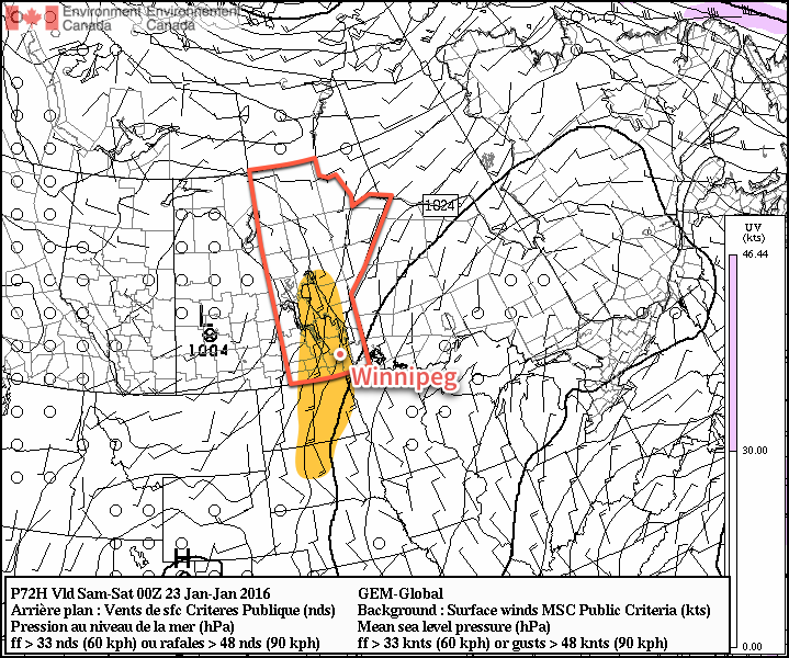
The GDPS shows the strong southerly winds (emphasized in yellow) expected over the Red River Valley on Saturday.
Temperatures will gradually climb to around -12 or -11°C by late in the afternoon—although it will feel closer to -25 throughout much of the day due to the wind chill. Temperatures will continue to rise overnight as the warmer air finally begins working its way into the valley; by Saturday morning the temperature is expected to climb to about -8°C in Winnipeg.
With strong warm air advection aloft and the surface flow dominated but the outflow from an Arctic ridge, it’s likely that Friday will be fairly cloudy as stratus streams northwards out of the ridge.
Warm Weekend Ahead
This weekend looks beautiful with temperatures well above seasonal expected throughout the Red River Valley. In Winnipeg, the temperature is expected to climb all the way to around the freezing mark under mainly cloudy skies. Sunday looks fairly nice, perhaps evening bringing some sun to the region, with daytime high closer to the -5°C mark.
Temperatures are expected to return to seasonal values for the start of next week.