A summer heat wave is on the way as a strong upper ridge builds over the Prairies. Winnipeg will likely see 30°C at least once by mid-week.
Monday
Today will feature increasingly cloudiness through the day as convective clouds develop with daytime heating. We may see a few showers or thunderstorms develop as these convective clouds grow, but any storms will be non-severe. Other than the chance of a shower, it will be a pleasant day with highs in the mid twenties and light northerly winds.
Tuesday
Tuesday will be one of the warmest days we’ve seen in a awhile as high temperatures climb up to the 30C mark in much of southern Manitoba. Skies will be mainly sunny and winds will be breezy from the south. It appears that the humidity will increase somewhat with the push of warmer air, but not too oppressive levels.
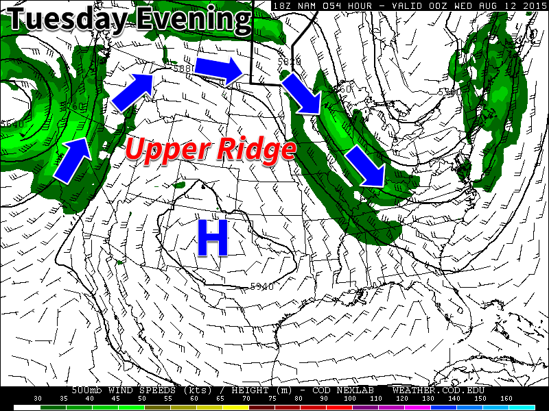
An upper ridge over western North America will bring warm weather to southern Manitoba this week
Wednesday
Wednesday should be the warmest day of the week with high temperatures climbing into the low thirties. Some weather models even suggest we may reach the mid thirties, but that remains to be seen. Humidity levels should edge up further on Wednesday, to uncomfortable levels. Humidex values will likely be near 40 in most areas by late afternoon. This higher humidity will also help to create a risk of thunderstorms on Wednesday. At this point it appears severe storms will be possible, but we’ll provide another update as the risk gets closer.
Long Range
The long range forecast suggests we’ll continue to see frequent periods of hot weather through mid August. However, it doesn’t look like the hot weather will be in place continuously, with frequent surges of cooler air breaking up warmer periods. The long range forecast also shows a fairly active storm track through our region, so there will likely be a fairly frequent risk of thunderstorms and precipitation over the next while.
A tropical disturbance that was once a powerful super typhoon over the open waters of the Western Pacific earlier this week has now slightly weakened and is taking aim at southeastern Asia.
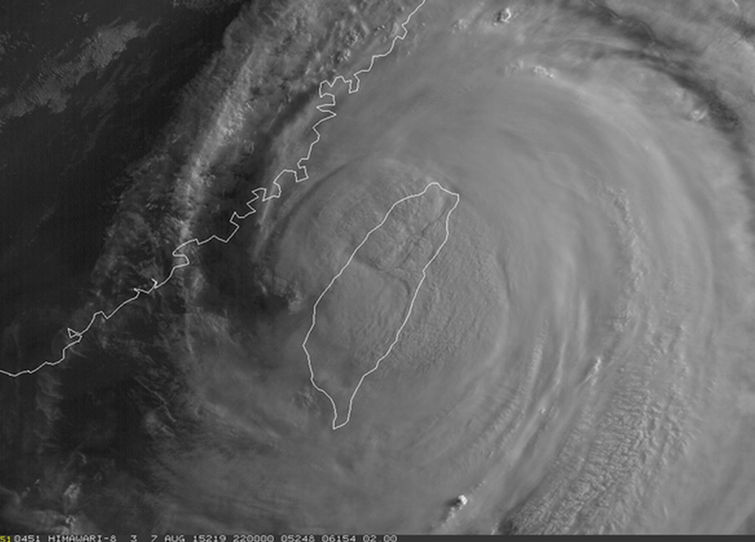
As of Friday night Soudelor was a typhoon of strength equivalent to a category two hurricane and had just made landfall on Taiwan’s northeast shores. The typhoon packed sustained winds of about 170km/h gusting to over 200km/h Friday night as it made a direct landfall on the island of Taiwan. The biggest threat with the typhoon, however, was rainfall. Taiwan’s rugged terrain meant that orographic lift (lifting of air pushed up the mountains) would greatly enhance precipitation amounts, especially on the north side of the island. Models showed that as much as a metre of rainfall (or more) could fall before it is all said and done.
Visible satellite image of Soudelor at sunrise late Friday evening (our time). (Source: Himawari Sat.)
The effects of typhoon Soudelor are still uncertain as of Friday evening but the Taiwanese authorities reported that there were over 2.6 million residents without power, wreaking havoc on day to day activities as well as travel in the region. In addition to that, as of Friday night there were four confirmed deaths associated with the typhoon, two of which were associated with the storm surge which had the biggest impact on the northeast shoreline. The station that clocked the highest rainfall amounts as of Friday evening was the town of Taipingshan, which was already well over a metre of rainfall (1,241mm). Taipei, which is less than 50km from this town, had already recorded an astonishing 500mm in some parts of the city.
Conditions are expected to continue to be poor until later today, as the heavy rains are expected to continue to fall in the northern half of the country. Soils will become saturated, if not already, and overwhelmed by the rainfall, resulting in mudslides in the mountainous regions – a region of Taiwan which is known to be very prone to these types of disasters. Soudelor’s effect on China isn’t expected to be as severe, but heavy rain/flooding will once again be the main threat as the tropical system moves over China’s mainland and begins to weaken.
A threat of severe thunderstorms will come to Southern Manitoba today as a trough of low pressure pushes across the region, tapping into very muggy air near the surface. The passage of this system will mark the beginning of a transition towards a summer heat wave as a potent upper ridge begins building over North America.
Friday: Severe Thunderstorm Threat
This morning’s cloud and drizzle will break up through the morning as our winds finally begin swinging around to the west/southwest, finally allowing some sun to begin poking through and allowing us to start climbing towards our daytime high near 25 or 26°C. As we move towards the afternoon, however, a trough of low pressure will begin pushing into the Red River Valley from the west, bringing with it the threat for severe thunderstorms.
Taking a look at the basic MIST principle for today’s convective potential:
Moisture: Moderate moisture will be in place today with surface dewpoints near 18°C and mixed layer dewpoints around 16°C.
Instability: As the trough swings into the region, mid-level lapse rates will steepen significantly alongside the erosion of the capping inversion thanks to daytime heating. By mid-afternoon, MLCAPE values near 2000 J/kg will develop with little to no capping inversion along the trough line.
Shear: Slightly backed surface winds ahead of the trough line coupled with approximately 25kt of 0–6km bulk shear will be sufficient to provide organization to any thunderstorms that develop.
Trigger: This is the most questionable aspect. Models differ on the strength of the trough line as it swings through; while some show little strength to it resulting in a lack of convergence and no convection, others show a stronger trough which would be sufficient to focus the energy and produce more substantial thunderstorm activity.
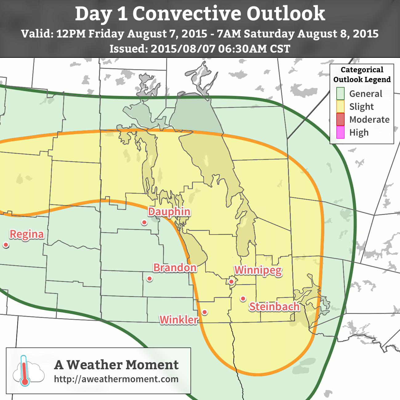
AWM Convective Outlook valid 12PM Friday August 7, 2015 to 7AM Saturday August 8, 2015
As a result, a slight risk of severe thunderstorms is warranted for much of Southern Manitoba. Any storms that develop will likely initiate as single-cell or supercell thunderstorms before growing upscale fairly quickly into linear convective elements. The primary threat with any storms that develop today will be strong winds and large hail, however rainfall rates may pose significant impact in storms despite accumulations likely not hitting any severe criteria.
Thunderstorms will move off towards the east through the evening, leaving behind clearing skies and a pleasant overnight low near 15°C.
Beautiful Weekend Ahead
There isn’t much to say about the coming weekend other than it will be quite nice. Daytime highs on both Saturday & Sunday will be near the mid–20’s with overnight lows in the mid-teens. Winds will be relatively light out of the northwest on Saturday and fairly calm on Sunday. There will be a bit of cloud cover left over on Saturday while Sunday will be mainly sunny.
Heat Wave Builds In Next Week
Next week will see very warm weather return to Southern Manitoba as a potent upper-level ridge builds across much of North America.
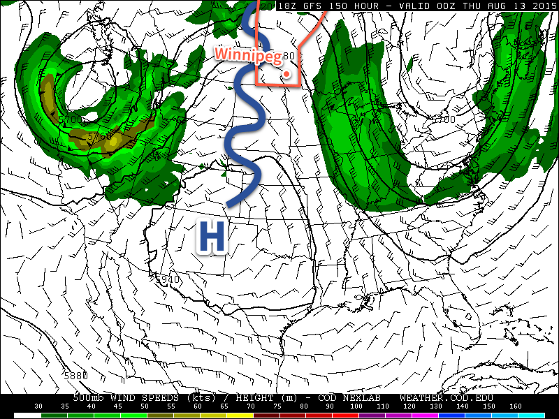
The GFS 500mb Height & Wind Forecast valid 00Z Thursday August 13, 2015 shows a significant upper-level ridge over much of North America.
As the upper ridge builds, a deep southerly flow will develop over the eastern Prairies, bringing significantly warmer air into the region. With 850mb temperatures forecast to reach 20°C or warmer, it seems likely we would see daytime highs in the low 30’s several days next week. One of the big questions is exactly how humid it will get, but we’ll have to wait until we’re closer to better assess that question. At this point, though, it seems quite likely that we’ll see a stretch of dry and hot weather next week.
The pleasant spell of cooler, drier weather is coming to an end today as a warm front pushing eastwards across the Prairies brings unsettled weather today and then a deeper southerly flow which will help the heat and humidity slowly build up through the region into the end of the week.
Wednesday
Today will be the first active day of the week as a warm front approaches from the west and pushes through the Red River Valley later this afternoon & into the evening hours. This system will spread showers and thunderstorms across southwestern Manitoba this morning and gradually push them towards the valley through the day. The rain will likely hold off until late in the afternoon or early this evening here in Winnipeg. Temperatures will climb into the low 20’s across the valley with winds picking up out of the south-southeast to 20–30km/h with some gustiness on top of that by mid-to-late afternoon.
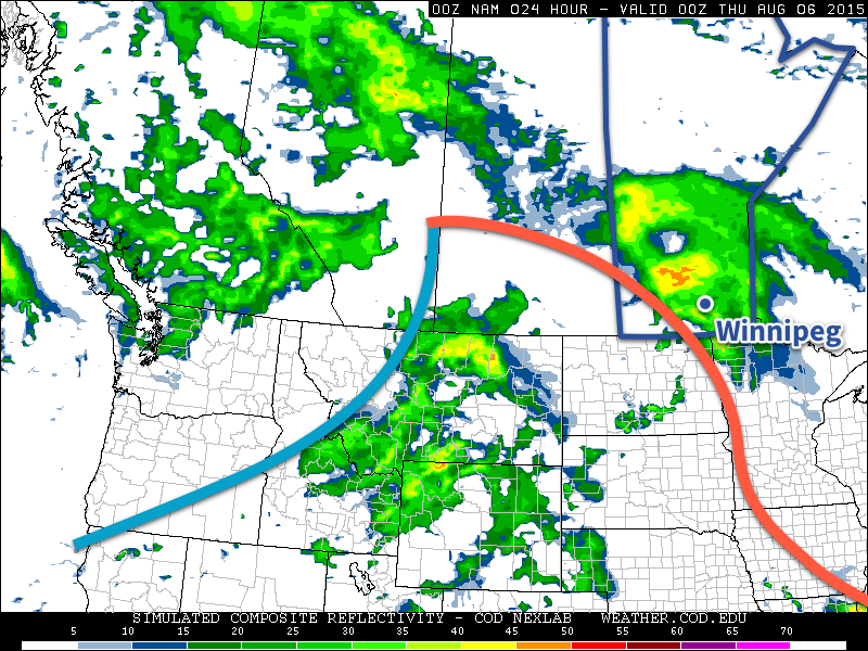
The NAM simulated RADAR refliectivities show a large swath of showers moving through Southern Manitoba this evening as a warm front pushes eastwards.
With the showers there will be a slight chance of an embedded thunderstorm…if we can manage some heating through the day with a bit of sunshine. If it ends up being overcast for a large area ahead of the front, the thunderstorm activity will likely be fairly mild with little-to-no chance of severe weather. On the other hand, if some sunshine manages to heat things up a bit, there will be a very borderline risk of some marginally severe wind or hail with some of the storms. That said, it doesn’t look particularly likely that we’ll see too much thunderstorm activity and, rather, we’ll see more moderate shower activity. The exception to this rule will be over southwestern Manitoba where there will be a slight risk of severe thunderstorms with main threats of large hail and damaging winds.
By the time things clear out late in the evening, most places will likely have seen around 5–10mm, but localized amounts of 10–20mm are possible. Temperatures will drop to lows in the mid-teens tonight.
Thursday
Thursday will be a muggier day with temperatures climbing into the mid–20’s. There will be some sunny breaks, but skies look to be trending towards the cloudier side of things. Another disturbance begins pushing into our region later in the day, which will bring another chance for showers or thunderstorms mid-afternoon into the evening hours. Temperatures will dip to the mid-teens again on Thursday night with a continued chance of shower activity.
Friday
Friday will see a more organized thunderstorm threat return to Winnipeg & the Red River Valley as the main upper-level disturbance swings through the province. Temperatures will climb to around 26°C or so with any leftover humidity getting flushed out by drier westerlies at around 30km/h. We may see some pop-up thunderstorms through the day, but at this point they don’t look like they’ll bring any severe weather. Friday night will see temperatures dip back to the mid-teens with a chance of some wrap-around shower activity pushing into the Red River Valley form the north on the back-side of the departing upper low.
Weekend Looks Pleasant
Looking ahead, the weekend looks great with high temperatures in the upper 20’s, relatively comfortable humidity, and little in the way of precipitation expected thanks to a ridge of high pressure working its way across the Prairies. Finally, rainy weather during the work week turning beautiful for the weekend!