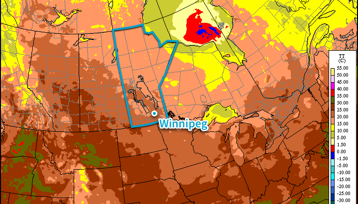
RDPS Surface Temperature Forecast – 00Z Tuesday July 21, 2015

Pleasant, Sunny Conditions to Start the Week

Tired of the phrase “chance of a thunderstorm” and want to just have a couple days without rain? Good news! It looks like Winnipeg & the Red River Valley will finally shake the unsettled weather pattern and see a couple days of calm, pleasant summer weather with very little chance of precipitation thanks to an upper-level ridge that will build into the Eastern Prairies.

The coming few days will see gradually warming as we transition from the cool air mass left behind from the systems that tracked across the region on Saturday & Sunday into a warmer air mass pushing in from the west. Today will be the coolest day with a daytime high of just 22 or 23°C under partly cloudy skies. There may be some isolated shower or thundershower activity, but at this point it looks like it would be very spotty in the Red River Valley. Temperatures will dip to around 12°C tonight.

Tomorrow and Wednesday will both be beautiful summer days with highs climbing into the mid-to-upper 20’s under mostly sunny skies. Winds look fairly calm, although by Wednesday afternoon we could see southerly winds begin to strengthen. At this point it doesn’t look too bad – perhaps 30km/h with some gustiness on top of that – but if the pattern speeds up a bit, we could end up seeing quite windy conditions out of the south by then. Conversely, if the entire pattern is a bit slower we’ll see calm conditions throughout the day. Overnight lows both nights will be in the low-to-mid teens.

Hot, Humid & Stormy Weather Returns for End of Week

Looking ahead into the second half of the week, the trend seems to be for the hot and humid weather to return. As the upper ridge transitions across the region, deep layer southerly winds developing will tap into more humid air to our south and begin increasing the dew point. By Thursday evening, the dew point could be as high as 20–22°C, making it feel very sticky out there. Depending on the exact daytime highs, Thursday and Friday could both end up feeling more like the mid-to-upper 30’s instead of the upper 20’s thanks to the humidity.
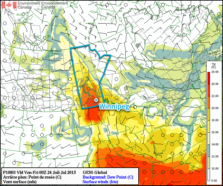
GDPS Surface Dew Point Forecast – 00Z Friday July 24, 2015
The GDPS is forecast dew point values climbing into the 20-22°C range by Thursady evening.

In addition to all that heat and humidity, a low pressure system tracking through at the end of the week looks to bring the potential for strong to severe thunderstorms, likely on Thursday. More on that later this week!
Typhoon Nangka Wreaks Havoc on One of Japan’s Main Islands

This past week a typhoon made landfall on one of Japan’s islands, the island of Shikoku and with it brought winds the equivalent of a category one hurricane gusting up to 185km/h.

[map type=”terrain” autofit=”1″ disable_scrollwheel=”1″] [pin]Island of Shikoku[/pin] [pin]Kamikitayama, Japan[/pin] [/map]


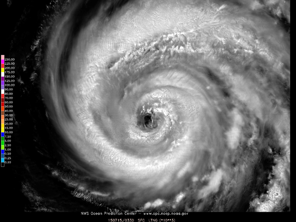
Nangka initially formed in the middle of the Western Pacific Ocean about over a week ago and slowly strengthened as it approached Japan; it traveled over 5000km to make landfall. Over open waters it peaked at the equivalent of a category four hurricane, with sustained winds of over 200km/h and gained super typhoon status. Slightly cooler ocean waters (of 26°C to 27°C) towards Japan weakened the typhoon somewhat before it made landfall, but with that said, the typhoon’s impacts were still fairly significant. In expectation of the typhoon 550,000 residents were either issued a mandatory evacuation notice or voluntary evacuation notice, in the most prone-to, low-lying areas near the coast.

Beautiful satellite image of Nangka earlier this week while it was still over open waters. (Source: NWS OPC)

In total, two people perished from the typhoon and about three dozen people sustained injuries – thankfully it wasn’t worse due to good planning by authorities to get the people most at risk out. Numerous rail runs and flights were cancelled, affecting about 200,000 people’s daily activities. Some flooding did occur as the typhoon brought a plume of tropical moisture to the region with it, which led to rainfalls in excess of 700mm in the hardest hit areas in 48 hours (740mm reported in Kamikitayama). Just over 100 houses were reported to have been completely flooded out

Since Nangka has made landfall it has progressed to its dissipating stage, and possibly extratropical transition by the end of the weekend. However, it will still bring with it the threat of heavy rainfall in the northern Japanese islands and mountainous areas even though it continues to weaken. On average there are 16 typhoons in the Western Pacific in a year, and this year’s count is currently at seven. Most storms form in the Western Pacific between May and November (because shear is weaker) but there are occasional storms that form in the other months of the year.

Thunderstorm Chances Continue into Weekend

The generally unsettled weather that has been in place over Southern Manitoba over the past week will continue for at least a couple more days as a large upper-level low pushes across the Prairies. For those tired of sweating the heat, though, a reprieve is on the way as drier air finally works its way into the Red River Valley.

Today will be a fairly pleasant day with a fairly sunny start and temperatures poised to climb up to around 26 or 27°C. As the temperatures warm up this afternoon, shower and thunderstorm activity will likely develop as a cold front pushes eastwards into the Red River Valley. Most areas through the valley will have a chance at seeing some shower or thunderstorm activity, however the chance will increase the closer you find yourself to the U.S. border. Any convection that does develop will push out the eastern RRV early in the evening, ushering in some cooler, notably drier air into the region behind the cold front. Friday night will mark the end of a very humid streak that has seen dew points in the upper teens or low 20’s for over a week. Expect a refreshingly cool overnight low of around 12°C.

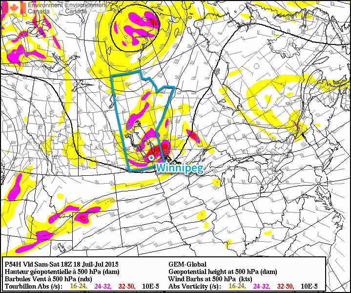
GDPS Forecasted 500mb Heights & Vorticity for Mid-day Saturday
Saturday will bring a risk of thunderstorms and funnel clouds to the Red River Valley as a vorticity-rich upper-level low moves over the region.

Saturday will bring yet another chance for showers and thunderstorms as the main upper-level low moves over Southern Manitoba. Temperatures will climb to around 22°C, which may be enough to pose a marginal risk for some severe thunderstorms in the afternoon; the biggest impact to be aware of, however, is the potential for cold core funnel clouds. These funnel clouds are developed through entirely different mechanisms than their stronger, supercell thunderstorm counterparts, and are substantially weaker and rarely result in a touchdown. If a cold core funnel cloud does reach the ground, it’s considered a landspout tornado. These tornadoes are short lived and usually very weak. While they do not pose the level of threat that a supercell thunderstorm tornado would pose, strong winds of any type can be dangerous. The shower and thunderstorm activity will push out of the region in the evening and we’ll see clearing skies as the low heads back down to around 12°C.

Sunday’s forecast will be short. Beautiful weather is on tap with highs in the mid–20’s, comfortable humidity, light westerly winds and mostly sunny skies. No complaints! Expect a low on Sunday night in the mid-teens. Finally some good weather news for a change!

Unsettled Weather Continues To Week’s End

The unsettled weather that’s been in place for the last few days will continue through the end of the week as the general instability remains in place as more weather systems push through the region.

Today will be a fairly pleasant day that’s quite similar to yesterday other than a couple degrees warmer. Temperatures should climb to around 28°C this afternoon with more clouds popping up and developing into an afternoon/evening chance of some scattered thunderstorms. Thunderstorm activity should be fairly limited as the main story will be the low pressure system that will move into Southern Manitoba overnight and will set the stage for Thursday’s weather. Expect temperatures to dip to just 19°C as increasing cloud and the humidity continue to keep temperatures warm.

Thursday Brings Heavy Rain Potential

Tomorrow may actually end up being quite a wet day as multiple models are showing a low pressure system moving through tapping into the ample moisture in the region to produce a fairly large, and intense, area of rain.

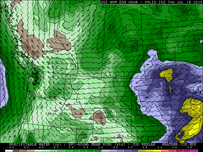
NAM Precipitable Water Forecast for 15Z Thursday July 16, 2015

The NAM (shown above) is forecasting precipitable water values as high as 1.8 to 1.9” (in the 45–50mm range) which is very high for our region. Precipitable water correlates strongly to potential rainfall amounts of storm systems[1], so it’s not unrealistic to say that rainfall totals of 1.5” to 2” (~ 35 – 50mm) are not out of the question albeit on the high end. If heavy convection were to set up, then even higher amounts would be possible. We’ll keep an eye on things and see how the storm progresses this evening; if the outlook changes much, we’ll provide an update at the bottom of this post.

So, the general forecast for Thursday would see the rain moving in overnight on Wednesday night and see the rain persisting at least until mid-day, but possibly into the late afternoon or early evening. Rainfall totals may end up being variable, but in general will likely be 20–40mm with the potential of seeing double that if system becomes vigorous enough. The high temperature will be in the 21 to 23°C range with an overnight low around 16°C. Winds will be fairly light much of the day.

Friday

The thunderstorm risk returns Friday, although it will be a fairly mild risk with just some isolated to scattered non-severe storms possible. The daytime high will sit near 26 or 27°C with light winds out of the southwest. The humidity continues to remain fairly high with dew points in the high teens. Skies will clear out Friday night as we head to a low near 15°C.


  1. Thunderstorm rainfall totals can greatly exceed PWAT values due to the convergence of the inflow wind that can “accumulate” PWAT from areas around the storm.  ↩