North Dakota Sees First Significant Tornado Day this Year

Last Saturday, on June 27th, North Dakota saw its first tornado outbreak of the year where 19 twisters touched down across the state.

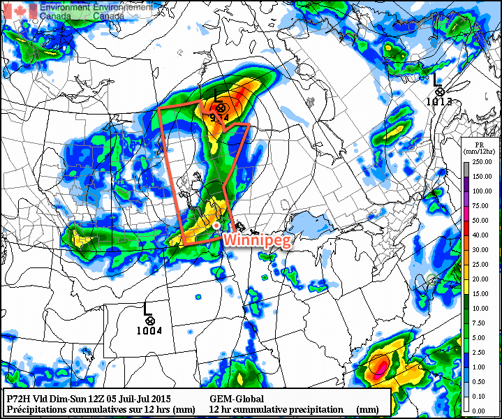
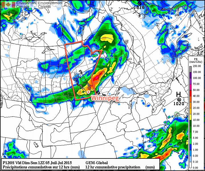
[map autofit=”1″ disable_scrollwheel=”1″] [pin tooltip=”Roseisle”]Roseisle, Manitoba[/pin] [pin tooltip=”Pisek”]Pisek, North Dakota[/pin] [pin tooltip=”EF-2 occurred just west of here”]Holmes, North Dakota[/pin] [/map]

A surface trough moving across the region associated with an upper level wave was the focus for severe weather across the region last Saturday. Plenty of instability was in place – MLCAPEs in the order of over 2000J/kg and sufficient shear (around 40 knots) was enough to support supercells in the region under the northwest flow. The first supercell in the region fired on the Manitoba side of the border and brought very large hail the size of tennis balls and strong winds to Roseisle and surrounding communities, such as Miami, MB. As the supercell drifted towards the south southeast it crossed the border into North Dakota near Walhalla, and held together quite well. A damage survey conducted by NWS Grand Forks it was found that several weak tornadoes were spawned out this supercell before it encountered a cluster of thunderstorms and weakened. Later on in the day several other tornadic supercells fired along the surface trough to the south of the initial supercell that was in northern North Dakota and produced more tornadoes.

After conducting a damage survey of the area, NWS Grand Forks concluded that 19 tornadoes touched down on June 27th, 2015. (Source: NWS Grand Forks)

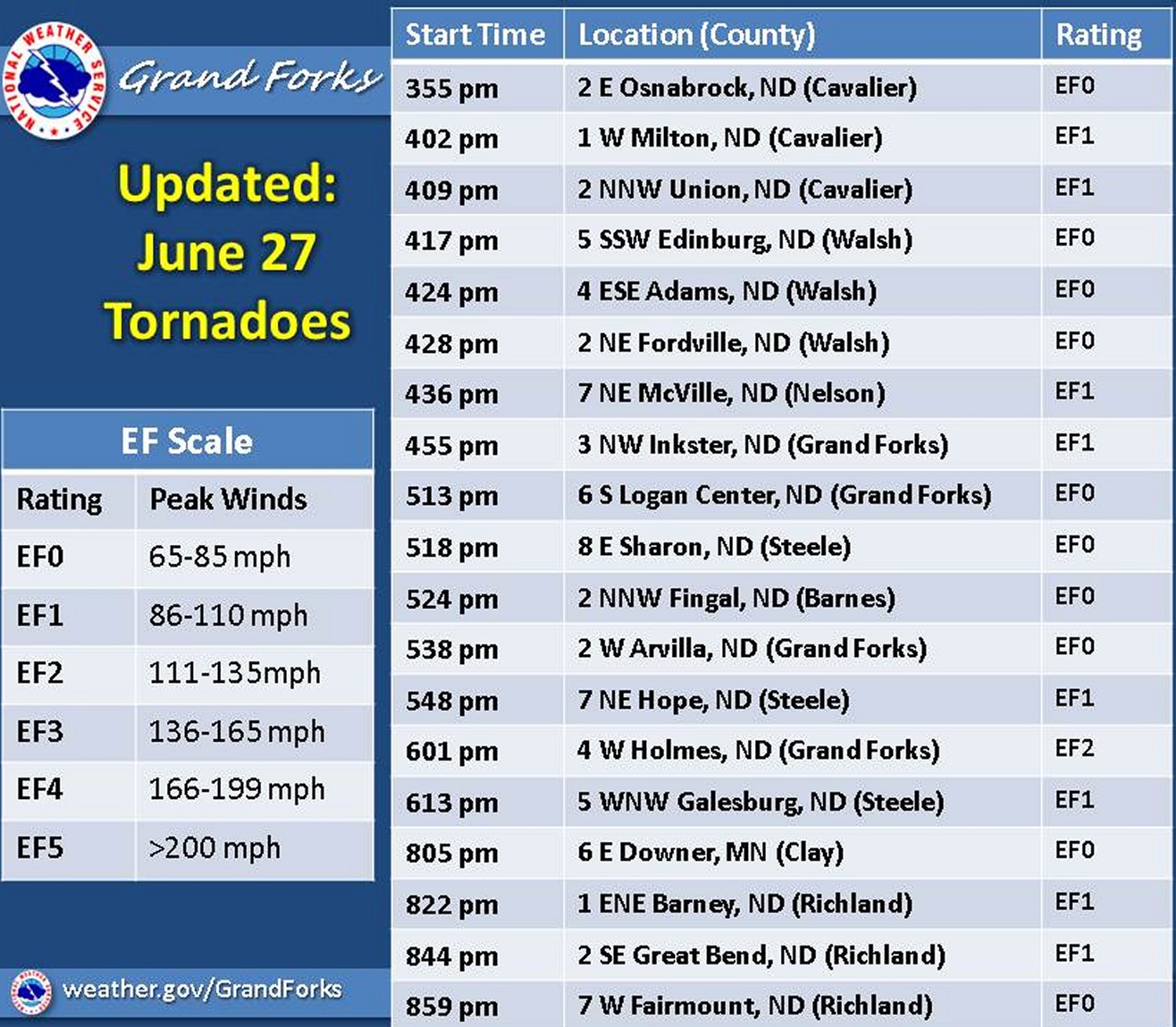
After it was all said and done, it was concluded that the strongest tornado of all, a cone tornado, was one that touched down near Grand Forks and was of EF-2 strength (winds between 177km/h and 217km/h). The other tornadoes reported were mostly of rope type and weaker; of EF-0 to EF-1 strength. Thankfully the NWS Grand Forks was quick on the warnings and did a good job alerting the public of a nearby tornado – no injuries or deaths were reported with any of the 19 tornadoes.

One of the rope tornadoes in ND observed near Pisek. (Source: Matt D)

In other weather news this week, the west Pacific has been quite active typhoon-wise as three tropical storms are currently active, and of those one is expected to strengthen significantly by the beginning of next week, possibly to super typhoon status.

Summer Warmth and Smoke Lead into an Unsettled End to the Weekend

Widespread smoke will remain in place today as a northwesterly flow gradually lightens and leaves the smoke to languish across Southern Manitoba. A low pressure system tracking into the northern Prairies tonight will bring a southerly flow at all levels to Southern Manitoba which will help clear skies out as well as lead towards an unsettled end to the weekend.

Today will bring partly cloudy skies which will seem a whole lot cloudier thanks to the widespread smoke that remains entrenched over Southern Manitoba today. That smoke will keep our temperatures slightly cooler than they would be under clear skies, leaving us with a high temperature later today of 26°C. Winds will remain fairly light through the day. The humidity will be more comfortable than yesterday’s dew points of 20°C; dew point values are expected to sit in the low- to mid-teens this afternoon.

Winds will begin picking up out of the south overnight which should help begin clearing the smoke out of our area. Our temperature will dip down to around 17°C.

Saturday will bring the humidity back to Southern Manitoba alongside gusty southerly winds to 30–40km/h. It will be quite a warm day with temperatures soaring into the upper–20’s or even hitting the 30°C mark while dew point values climb back towards the 20°C mark as the southerlies bring in more humid air from the Northern Plains.

GDPS 12hr. QPF valid Sunday morning.
The GDPS continues to forecast a swath of nocturnal convection occurring on Saturday night.

Saturday night will see thunderstorms initiate over Western Manitoba then slowly push southeastwards. There will likely be a chance for some severe thunderstorm activity over Parkland Manitoba; we’ll take a closer look and issue a convective outlook if warranted tomorrow. These showers and thunderstorms will slowly stall out towards the Red River Valley near morning and then sit over the region for much of Sunday. Temperatures will climb to a very humid 23°C or so on Sunday before the cold front finishes pushing through.

Behind the cold front, cooler and less humid air will begin working back into Manitoba. Sunday night will see the coolest overnight low in a while as it dips towards the low teens. With that cooler, drier air will come a northwesterly flow which will likely mean a return to smokier conditions.

Summer Warmth Under Smokey Skies for Canada Day

It’s safe to say that alongside all the smoke from forest fires raging across the Northern Prairies, summer has arrived. With daytime highs in the mid- to high–20’s for the coming 5 days and overnight lows similarly warm at nearly 5°C above normal, the cool weather of just under two weeks ago[1] is long gone!

Hot and increasingly humid weather is in store for the second half of the week, however temperatures will likely fall short of what their potential is given the haze and smoke that will advect over the southern half of the province from the fires to our northwest in Saskatchewan & Alberta.

Today will be a mild day with highs in the mid–20’s or so and some haze moving in. There’s a marginal chance of some isolated thundershower activity, but the haze & smoke aloft will likely keep things just cool enough that any convective activity is halted or severely limited.

The humidity will remain mild today with dew point values around 15–17°C. Expect temperatures to dip to around 16°C tonight.

Thursday and Friday will both be warm days with more noticeable humidity present. Dew point values are expected to climb into the upper teens, making it start to feel a bit swampy out there. There may be a bit of a reprieve from the smoke on Thursday, with just a bit of haze around, but it looks like more noticeable smoke will return for Friday. Both days will see highs in the mid- to upper–20’s, but with a bit of a footnote[2] that the high could be a degree or two higher or lower depending on exactly how much smoke manages to advect into the region for Friday.

Wet Weekend Ahead?

Weather models are beginning to come into agreement of a fairly significant storm system impacting the Prairies over the weekend.

GDPS 12hr. QPF valid Sunday Morning
The GDPS is forecasting a wide swath of rainfall across the Southern Prairies on Saturday night.

It’s still early to say, but it looks like there’s the potential for elevated convection on Saturday night, perhaps bringing some night-time thunderstorm activity to Winnipeg, and Sunday looks like it may bring a few showers to the region with a bit of remnant instability. We’ll keep tabs on this system as we head towards the weekend and have an update in Friday morning’s blog post!


  1. Overnight lows dipped to just 4.6°C on the morning of June 18th!  ↩
  2. Note: not an actual footnote.  ↩
Smoke over SK & MB - June 28, 2015

Smoky with a Risk of Thunderstorms

This week will start out with hazy skies from forest fires burning over Northern Saskatchewan and Alberta. There will also be a risk of thunderstorms today as a cold front moves through southern Manitoba.

Monday

Today will feature hazy skies, as extensive smoke from northern Saskatchewan/Alberta continues to pour south-eastward into southern Manitoba. The smoke will likely hold down high temperatures to the mid twenties, when they would otherwise be in the upper twenties. Despite the cooler temperatures, it is still expected that storms will develop along a cold front ahead of an incoming upper disturbance. At this point it appears that storms will be strong to marginally severe, with the highest potential for severe storms being in south-eastern Manitoba. The main threat with storms tomorrow will be large hail, although gusty winds are also possible. The main uncertainty surrounding tomorrow’s storm threat is how much the smoke will affect atmospheric (in)stability. If smoke is less extensive than expected, storms could potentially be stronger due to extra daytime heating.

Tuesday

Tuesday will be a nice day, with temperatures in the mid twenties under mainly sunny skies and light winds. There may still be some lingering smoke, but it shouldn’t be as extensive as earlier in the week. No precipitation is expected.

Wednesday

Wednesday will be another pleasant day in southern Manitoba. Temperatures will be in the mid to upper twenties under mainly sunny skies. Winds will be light once again and there is only a slim chance of showers.

Long Range

The medium-term forecast suggests we’ll generally see normal to above-normal weather for the next week or so. Beyond that it appears there may be slightly more unsettled conditions as we see more frequent chances for stronger weather systems passing through the region.