More Warmth Ahead This Week

The weather this week will continue from where the weekend left off as warm and mainly sunny conditions prevail. Temperatures will remain in the upper twenties, before dropping off a bit mid-week.

Monday

Today will be mainly sunny, although some upper-level cloud may drift through southern Manitoba as a result of a large weather system to our south. Other than that, there isn’t much weather to discuss for today. Temperatures will climb into the upper twenties and winds will remain light.

Tuesday

Tuesday looks to remain quite warm, with temperatures once again reaching the upper twenties. During the afternoon it is expected that the atmosphere will destabilize a bit due to slightly higher humidity and daytime heating. This may result in the development of some showers and thunderstorms. Any storms that do develop will be weak with only very small hail and/or brief gusty winds being possible.

Wednesday

A cold front will pass through southern Manitoba on Wednesday morning, ushering in slightly cooler temperatures. Highs are expected to be in the low to mid twenties under mainly sunny skies. There may be some light showers associated with the passage of the cold front, but other than that no significant weather is expected.

Long Range

The long range forecast suggests we’ll generally stick with above-normal temperatures, although not necessarily as warm as it has been recently. Highs will more likely reside in the low to mid twenties, although the occasional jump into the upper twenties is certainly possible.
Southern Plains States Faced with Serious Flooding

The western troughing pattern, with occasional cut-off lows that have been hanging around the west coast have done good work in eliminating the drought that was entrenched in the Southern Plains past few years. The copious amounts of rain that have fallen in the last month or so has not only taken out a large part of the drought, but caused serious flooding issues in the region. This heavy rainfall stemmed from several storm types; rounds of trailing severe thunderstorms, large areas of stratiform rain as well as slow moving storms the would drop significant amounts of rain. These have all occurred in the Oklahoma/north Texas region since the end of April.

[map type=”hybrid” autofit=”1″ disable_scrollwheel=”1″] [pin tooltip=”Lake Eufalufa”]Lake Eufalufa, ok[/pin] [pin]Norman[/pin] [pin]Wichita Falls[/pin] [/map]

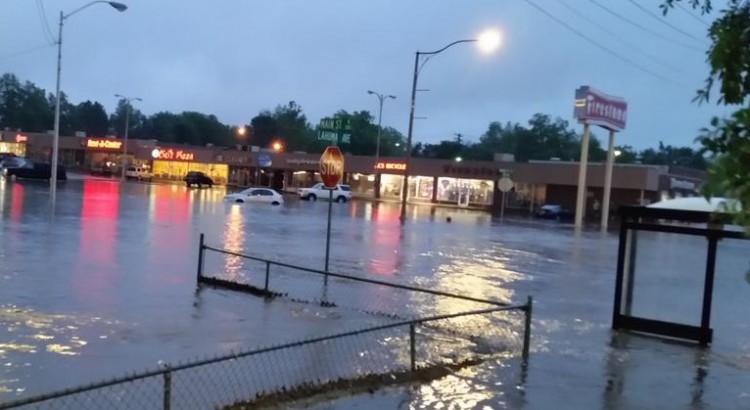
The flooding is not only wreaking havoc on farmers in the area, whose crops are struggling due to all the rain, but also the general population as several major highways in the region have been washed out and forced to close. Lake Eufalufa, one of Oklahoma’s major lakes is currently 14 feet above normal, causing many campsites nearby to be shut down. In Wichita Falls, Texas, neighbourhoods in low-lying areas were forced to evacuate ahead of the next system – the city announced they would be cutting power at all these neighbourhoods to prevent electrical fires. In Norman, Oklahoma, heavy rains from trailing storms turned parts of its Main Street into a fast flowing river this past week. It’s unclear how many people have been affected since the beginning of May throughout the south but two people are known to have died in the floods. The good news is the extreme drought, which covered 29% of the region last year, is now down to 0%.

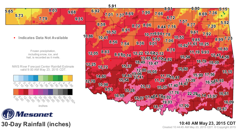
Past 30-day rainfall in Oklahoma shows significant rainfall across much of the state, with a 495mm tally in Norman.

More rain is in the forecast for most of these regions this weekend – with possibly another significant rainfall in the works. In some of the hardest hit areas, such as central Oklahoma, more than 75 additional millimetres could fall this weekend; flood watches are already in effect and meteorologists are urging residents to limit travel.

Summer Arrives in Southern Manitoba

The heat is on the way to Southern Manitoba as warmer air finally spills eastwards bringing positively summer-like weather to the area.

There is astonishingly little to say about the coming few days. Temperatures will climb into the mid–20’s Friday, Saturday and Sunday with overnight lows near 11 or 12°C all 3 days. Winds will be fairly light with the slight possibility of some breezier conditions on Saturday afternoon, but even there it would only likely be 20–30km/h. No precipitation is expected, although there will be a slight chance of some showers on Saturday north of Winnipeg along a very weak cold front from Dauphin eastwards across the Interlake.

All in all it will be a perfect weekend to get outside either here in the city or head up to the cottage for a truncated mulligan of the May long weekend!

Uncertain Start to Next Week

The beginning of next week presents another interesting forecast challenge as yet another Colorado Low forms and pushes northwards into the Dakotas. Model forecasts currently diverge quite a bit, demonstrated easily by the current forecasted storm-total precipitation for Winnipeg produced by each one:

Forecast Storm-Total Precipitation for Monday’s Colorado Low
Model Storm-Total Rainfall (mm)
GDPS 16
NAEFS 8
GFS 0

In general, amounts increase to the south and east of Winnipeg in all the forecast scenarios. Why the big difference? The track of the Colorado Low will depend significantly on how it interacts with thunderstorm activity that develops through the Central Plains as it ejects northeastwards from Colorado. If the convection forms close to the upper-level low and has a significant amount of moisture wrap into it, it will strengthen more, tilting the entire upper-level trough and pulling the system further northwest. If the moisture from the convection pulls off to the east over the upper-level ridge, then the system will be a bit faster, weaker and further southeast.

At this point, there’s still far too much disagreement in the models to make much of a forecast. Overall, the GDPS – currently forecasting the highest amounts for Winnipeg & the RRV – tends to produce too much convection and over-develop lows. They’ve made significant improvements in the latest version of the GDPS, but it still tends to have that strong bias which results in slower systems further to the NW. I think the GFS solution of nothing at all to likely be missing the mark and not quite worth banking on.

That leaves us with the middle-of-the-road answer. Likely some rain on Monday, however not likely as much as advertised by some weather sources right now. We’ll certainly keep an eye on things as they develop and have some updates later in the weekend on how it looks like things are developing.

But for now, get out there and enjoy the hot & dry weather!

A Graceful Return to Form

A quiet week is ahead weather-wise as an upper-level ridge over the region dominates the weather for the remainder of the week. No precipitation is anticipated for the rest of the work week while temperatures slowly climb to above-normal values.

Wednesday
19°C / 4°C
Sunny

Thursday
20°C / 9°C
Sunny

Friday
24°C / 12°C
Partly cloudy

The next few days will be mainly sunny with just a few more clouds working in on Friday. No rain is expected. Daytime highs will start near 19°C today and climb to 24°C by Friday. Overnight lows will remain chilly tonight with lows just near 4°C, but then push towards above-normal of 9–12°C.

Long-Range Outlook

Overall, the weekend is looking quite nice. Temperatures will be in the low-to-mid 20’s with overnight lows in the upper single digits. Some showers or thunderstorms will be possible along a weak cold front draped across the province – likely north of Winnipeg through the Interlake – but at this point anywhere along or south of the Trans-Canada Highway looks fairly dry.

Heading into the start of next week, though, some models are hinting at the possibility of another – albeit weaker – Colorado Low impacting southern Manitoba. The GDPS[1] is forecasting a very rainy Monday with elevated convecting drenching Southern Manitoba with over an inch of rain. The NAEFS[2] takes a more middle ground approach and pushes a weaker system a bit further east, with our region being grazed and getting something in the 5–10mm range. The GFS[3] produces the weakest solution with an even weaker low pushed even further east with little-to-no impact on Southern Manitoba.

It’s too early to say too much about that system other than we’ll be sure to keep an eye on it as we head into the weekend. There are numerous factors which make it look not nearly as bad as the storm we had over the long weekend, so even though it may be the 3rd Colorado Low in 2 weeks, it may not be a significant issue for the region.


  1. Global Deterministic Prediction System – The Canadian long-range forecast model.  ↩
  2. North American Ensemble Forecast System  ↩
  3. Global Forecast System – The United States long-term forecast model.  ↩