Summer Warmth Arrives

Summer-like warmth has arrived for Winnipeg and the Red River Valley thanks to an upper-level ridge moving into the region that will spread warm air over Manitoba for the coming days. Some rain looks likely on Thursday evening as a “cool” front passes, but the other days through the second half of the week look beautiful with plenty of sun to go along with the warmer weather.

Today will be a mainly sunny day with a high near 21°C. Winds will remain fairly light through the day as well. With an overnight low near 8°C or so, the warmth should hang on into the evening making for a pleasant evening to be outside.

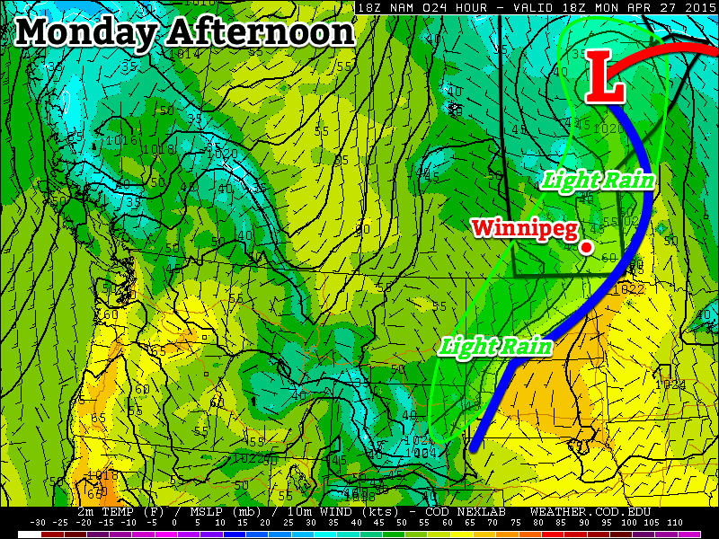
Thursday will bring a fair amount of cloud, however the sun will still poke out a few times through the day. Winds will be breezy out of the south, picking up to around 30–40km/h with gusts to 50–60km/h or so. Heading into the second half of the afternoon should really bring in the thicker cloud ahead of the approaching “cool” front. A band of showers will move in sometime between 6–9PM and last for a few hours as they move through.

RDSP 12hr. Precipitation Accumulation
The RDPS shows around 2mm of rain through much of southern Manitoba associated with the passage of a “cool” front on Thursday evening. Image above is total accumulations from Thursday evening at 7PM to Friday morning at 7AM.

Precipitation is expected to be fairly light, however, with total accumulations around 2mm, although if the odd convective cell gets going, some places may see closer to the 5mm mark. Winds will taper off with the passage of the front and temperatures will drop to around the 7°C mark with clearing skies overnight.

Friday will be another pleasant day with light winds, mainly sunny skies and a high near 21°C. Expect a low near 8°C on Friday night.

Showers to Start the Week

We’ll see some shower activity today as a frontal zone remains stalled through southern Manitoba. Conditions will improve rapidly by Tuesday however, as sunny skies return.

A frontal zone in southern Manitoba will bring some rain showers to the region on Monday

Monday

We will receive some light rain today as a frontal zone is draped through southern Manitoba. Rainfall accumulations will be small in general, not amounting to more than a few millimetres in most cases. Despite the rain, temperatures will climb into the low teens under mainly cloudy skies and light winds.

Tuesday

Tuesday looks to be a beautiful day as temperatures climb into the mid to upper teens under mainly sunny skies. Winds will remain as we sit under a surface high, making for very nice conditions!

Wednesday

Wednesday looks to be even nicer than Tuesday, as temperatures climb into the low twenties under mainly sunny skies. Winds will be a bit stronger than on Tuesday, but not by a lot. An approaching low pressure system will be responsible for pumping these increasingly warm temperatures into Manitoba.

Long Range

Weather models suggest we’ll continue to see above-seasonal temperatures for the remainder of the week. Further out into the long-range the forecast is a bit uncertain, so I won’t delve into that right now. Get out and enjoy what should be a great week (aside from Monday)!

Deluge of Rain Falls on Eastern Australia

A persistent area of low pressure off the coast of Eastern Australia is to blame for extreme amounts of rainfall that fell during the mid-week.

[map autofit=”1″ disable_scrollwheel=”1″] [pin]Sydney[/pin] [pin tooltip=”Maitland”]Maitland, Australia[/pin] [pin tooltip=”Dungog”]Dungog, Australia[/pin] [/map]

An upper level low that was cut-off from the main jet stream to the south was the reason for the slow movement of the surface low. Sydney and surrounding regions were hardest hit from the storm where over 300mm fell in some areas in less than 24 hours. Dungog and Maitland, towns north of Sydney, received some of the highest amounts in the region; 312mm fell in Dungog in 24 hours and 301mm fell in Maitland in the same amount of time. Sydney received 225mm during a two-day span – relatively speaking, this is a significant rainfall for them. According to the Australian Bureau of Meteorology this was the most rain Sydney has received during two-day period in more than a decade. What made conditions even worse was that winds howled to 80km/h in Sydney and over 130km/h in three separate regions on the east coast of Australia. The high winds made for swells of over 6m out at sea.

The state of New South Wales is pictured with one-week rainfall totals. Bright pink shaded areas are areas that saw over 300mm of rain fall throughout the week.

Due to the high winds and flooding rains, power to 215,000 people was knocked out in the region. In addition to that, creeks quickly became dangerous, fast-flowing rivers in the Dungog region. Several houses in Dungog were washed away due to the floodwaters and unfortunately four people perished.  There were also 150 water rescues that had to be executed. As of Friday morning where were still a few thousand people isolated by floodwaters that cut off main roads. In total, 12 communities were officially declared a natural disaster area by the government – insurance companies estimate the damage to be around 100 million dollars.

Since then the soggy weather has continued, off and on, throughout the end of the week. With another system and associated cold from arriving from the west today, the chance for rain continues – amounts will be nowhere near the ones that were observed this past week, however.

Pleasant Weather Returns

Winnipeg will see a reprieve from the below-normal temperatures this weekend as the ridge of high pressure that’s brought the cooler weather shuffles off to the . In its place, a southerly flow will return warmer air to the region with temperatures climbing back to near the seasonal mark.

Over the next few days, no significant weather is expected in Winnipeg or the Red River Valley. Today will start off with some lingering cloud that will clear out through the day. Temperatures will climb to a high of around 13°C with a light southeasterly wind. Expect a low near 0°C under clear skies tonight.

Saturday will bring mainly sunny skies, light southeasterly winds and a high near 16°C. Saturday night will see a low near +2°C with a bit of cloud cover.

RDPS forecast Temperature for Friday Afternoon
The RPDS weather model is forecasting highs climbing above 15°C in Winnipeg on Saturday afternoon.

Sunday’s high will also be near 16°C, however with a few more clouds than Saturday. The temperature will drop to 7°C or so on Sunday night with increasing cloudiness overnight.