Temperatures will gradually warm this week as we move back into more spring-like conditions.
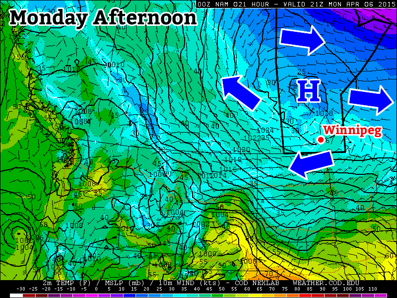
Monday will remain cool as a strong high pressure sits just off to our north
Monday
Monday
1°C / -4°C
Mainly Sunny
Today will remain on the cool side as a surface high remains parked off to our north. This high will keep arctic-ish air over southern Manitoba, suppressing high temperatures to near the freezing mark. Winds will be light however, making for a pleasant, but slightly chilly day.
Tuesday
Tuesday
4°C / -1°C
Mix of sun and cloud
Tuesday will see a slight uptick in temperatures over Monday, with values climbing a few degrees above zero. Skies will be a mixture of sun and cloud and winds will be breezy from the east. There may be a bit of snow on Tuesday night as a strong upper-impulse moves through, but accumulations will be small.
Wednesday
Wednesday
7°C / 0°C
Mainly Sunny
Wednesday will see temperatures increase further, with highs in the mid to upper single digits in southern Manitoba. Skies should remain mainly sunny with light winds, making for a nice day!
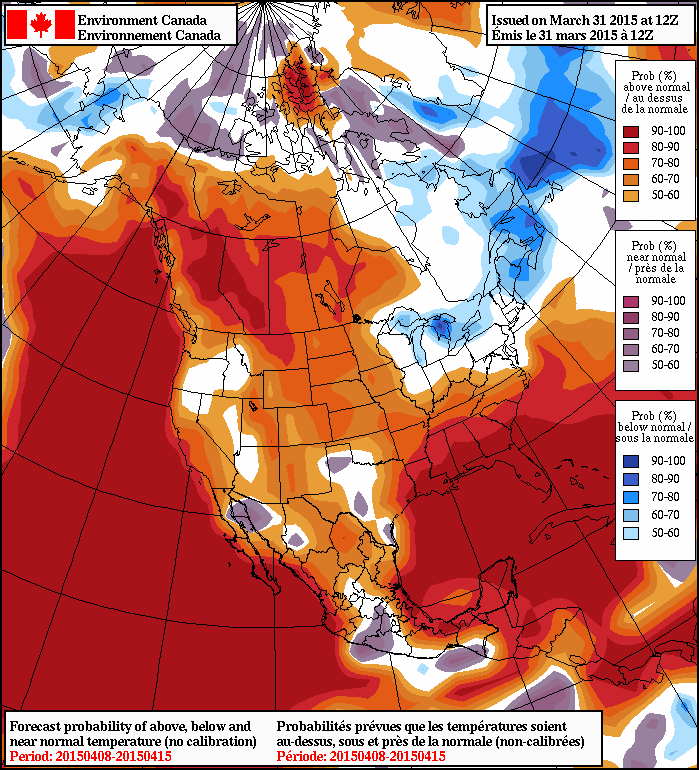
Long Range
The long range forecast shows increasingly warm temperatures toward the end of the week. Models suggest that above-normal weather will last into mid-April at least. This means highs frequently into the teens and very long range models even show our first 20C readings of the year!
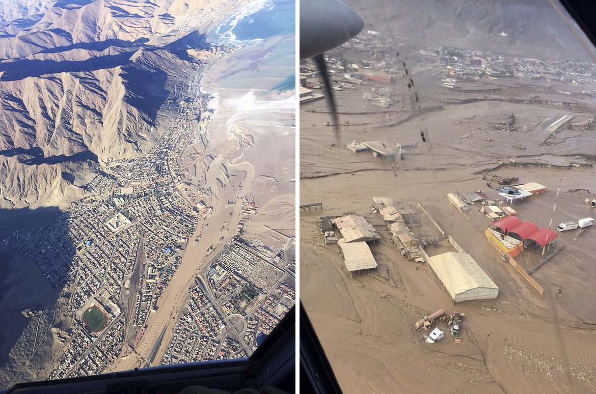
A rainfall event that occurred near the end of March in Northern Chile did some major damage to numerous towns in the region. The storm system that brought the rain was the product of an upper level low that remained nearly stationary for several days in the area. The rainfall amounts, which might seem insignificant to Manitobans, are significant for that area because the storm system brought rain to one of the few places on the planet that receives very little precipitation every year – the Atacama Desert.
The flooding and mud flow event affected about 30,000 Chileans and destroyed 5,900 houses. In the hardest hit regions only about 65mm of rain fell, but due to the extremely dry soil conditions in the region – which have trouble letting rainfall percolate through – flooding occurred. According to Wundergroud meteorologist Jeff Masters, Antofagasta recorded 24.4mm of rain in 24 hours while their average precipitation per year is 3.8mm. Santiago, Chile recorded 35.7mm of rain during the event, which is a significant amount in comparison to the 6mm total rainfall they typically receive during the entire month of March.
Aerial images of a flooded region in the Atacama just south of Antofagasta. (Source: Reuters)
The flooding rains triggered flash floods which swept away cars, houses and washed away one of Chile’s main highways in 3 places in the normally arid part of northern Chile. In total, 24 people have perished from this event and there are still over 50 that are missing where the mud flows occurred. Rescue efforts are still ongoing for people in remote locations and the cleanup in the towns has begun as 7,000 troops have been brought in.
In other news, the Philippines are expecting typhoon Maysak to make landfall this weekend. Maysak was once a super typhoon (category 5) but has since encountered cooler waters of the Western Pacific and has weakened to a category 1 typhoon as of Friday night. The main risk with this storm is the heavy rainfall that it will bring to the Northern Philippines.
Unseasonably cool temperatures will be seen across all of Manitoba through the duration of the Easter long weekend thanks to an Arctic air mass that was ushered into the region behind a potent cold front that brought intense snow showers and strong winds yesterday. In addition to the cooler temperatures, the s-word will likely be seen in many regions along and south of the Trans-Canada corridor over the next couple days.
Friday
-1°C / -9°C
Flurries beginning midday
Saturday
-3°C / -12°C
Morning snow likely, then clearing
Sunday
-2°C / -10°C
Mainly sunny & cool
A clear and cold start to the day in Winnipeg will see more cloud move into the area through the morning as a weak disturbance slides through the region. Flurries will move into the Red River Valley midday and linger into the evening. Winds will be light and daytime highs will climb to around -1°C. A chance for flurries will persist overnight as another weak disturbance begins approaching from Saskatchewan. Temperatures will dip to around -9°C tonight.
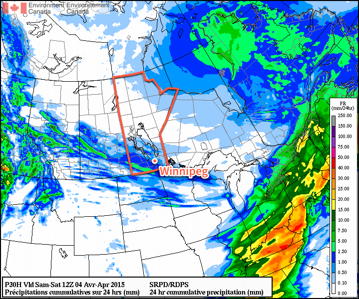
Precipitation totals forecast by the RDPS from Friday morning through Saturday morning.
As the next disturbance ripples through tomorrow morning, it will push an area of snow through the province. Amounts from this band will be around 1cm and will be centered from the Parkland region southeastwards into the southwestern Red River Valley. Winnipeg will be on the northern edge of the system and will likely see some snow through the morning hours. Once the disturbance moves past, clearing will begin pushing into the Red River Valley. Daytime highs will be a bit cooler than today at around -3°C or so with winds out of the north at 20km/h. Saturday night will bring mainly clear skies and a low near -12°C.
Sunday will be another cool, but mainly sunny, day. For areas near the U.S. border, the story will be different as a low pressure system moving through the States pushes a band of flurries through the region Saturday night into Sunday morning. Highs will be around -2°C on Sunday with lows down to -10°C on Sunday night.
Long Range
Next week is looking like a return to form; daytime highs are expected to rebound to a seasonal 6°C by mid-week at the latest when a chance for showers returns as another low pressure system moves through Manitoba. Before then, we’ll see plenty of sunshine making for fairly pleasant days despite the slightly cooler-than-normal temperatures.
Some of the warmest weather so far this year will move into the region today, drawn eastwards by a fairly strong spring storm moving through the Central Prairies. The warmth is not meant to last, though, as a strong cold front pushes through and brings below-normal temperatures for the remainder of the week.
Wednesday
16°C / 2°C
Windy with sunny breaks this afternoon
Thursday
⇓ -2°C / -12°C
Cloudy & windy; chance of showers or flurries
Friday
0°C / -8°C
Mainly sunny & cool
Today will be quite a warm day thanks to very mild air over our region; 925mb temperatures are expected to climb to around 9°C, which should translate to daytime highs near 15 or 16°C once we sunshine this afternoon. Speaking of sunshine, while today is starting off cloudy, we should the cloud cover break up this afternoon as the dry slot associated with the Central Prairie low moves across Southern Manitoba. Alongside the sunshine and clearing will be fairly gusty westerly winds to 30–40km/h with gusts as high as 60km/h. The winds will taper off in the evening as we head to an overnight low of around +2°C.
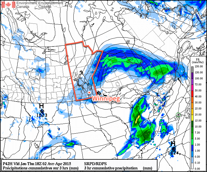
The RPDS shows an area of light precipitation moving through the Red River Valley on Thursday with a relatively tight pressure gradient that will produce gusty northerly winds.
Thursday will be a significantly less pleasant day as a cold front pushes through Southern Manitoba, bringing with it cooler temperatures, gusty northerly winds and a fairly good chance for some shower or flurry activity. Temperatures in Winnipeg will slide through the morning, settling near –1 or –2°C for much of the afternoon as gusty northerly winds to around 40km/h tap cooler air from the north. The best chance for any shower or flurry activity would be through the morning & early afternoon. Skies will clear out Thursday evening as we head to a low near –12°C.
Friday will be a benign weather day for Winnipeg & the Red River Valley, but temperatures will be well below normal. Daytime highs will only be around +1 or +2°C through the Red River Valley, which is a few degrees below normal for this time of year. Fortunately, winds will be light and with that increasingly strong April sun shining, it won’t feel so bad. Expect temperatures to drop to around –8°C on Friday night with partly cloudy skies.
Quiet Weekend Ahead
The weekend is looking fairly quiet for Winnipeg with seasonal to slightly below-seasonal temperatures and a few clouds. A ridge of high pressure building in from the Arctic looks to keep most disturbances to the south of Winnipeg, however with the main frontal zone setting up near the U.S. border and a few shortwaves rippling along, areas along the U.S. border in Southern Manitoba may see a few showers or flurries through the weekend. Nothing significant is expected.
The NAEFS 8-14 day temperature anomaly forecast show above-seasonal warmth returning to Manitoba.
In the longer range, it looks fairly likely that we’ll see a return to above normal temperatures through the second week of April as the storm track shifts back further north; while above normal temperatures will return, it looks like much of the warm weather will be associated with weather disturbances, making it likely that we’ll see more of a “roller coaster” temperature pattern than a prolonged period of warm, dry weather. Only time will tell, though! For now, expect a few cool days and then a stretch of near-seasonal temperatures.