This week will start out warm, but a bit unsettled thanks to a series of low pressure systems that will pass through the region, bringing variable weather conditions.
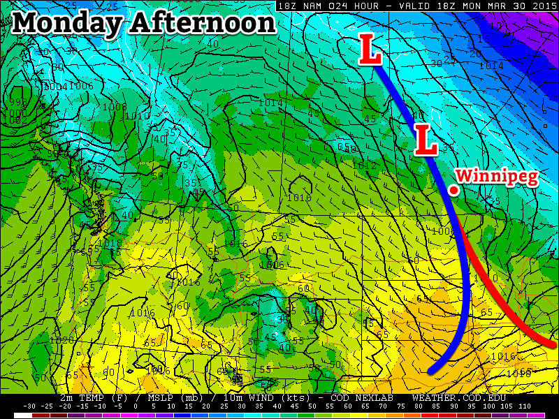
The first of a series of low pressure systems will pass through Manitoba on Monday
Monday
Monday
13°C / 0°C
Mix of sun and cloud with chance of showers
Today will be a mixture of sun and cloud as a low pressure system passes through the region. This low may generate some shower activity in southern Manitoba, but accumulations will be small. A cold front will pass through in the afternoon, causing winds to pick up from the north-west. Temperatures should climb into the low teens in most areas making for a warm but slightly unsettled day.
Tuesday
Tuesday
14°C / 5°C
Mainly sunny
Tuesday will be a nice day in southern Manitoba. There will be some cloud cover, but there should be more sun than cloud. Temperatures will climb into the low to mid teens with increasingly strong south winds. Overall, a pleasant spring day!
Wednesday
Wednesday
13°C / -2°C
Mainly cloudy with showers
Wednesday will see the return of unsettled conditions as another low pressure system approaches the region. This system will be quite powerful, but luckily most of the heavy precipitation (and that in solid form) will remain to our north. We will nonetheless see some shower activity and mainly cloudy skies. Winds will shift from southerly in the morning to westerly in the afternoon.
Long Range
The long range forecast continues to look quite variable. After Wednesday’s system exits the region we’ll see markedly cooler weather as cold air floods down from the north. Following this cool-down it appears that temperatures will hover around seasonal values, give or take a few degrees.
First Significant Severe Weather Event of the Season Strikes Oklahoma
This past Wednesday severe storms erupted across much of Oklahoma bringing with them very large hail and even tornadoes. It was the biggest severe weather day this year in the states, up to now (but many more are to come). A surface low was located in central Oklahoma with dryline extending southward, cold front crashing south from the north side of the low, and a warm front extending northeastwards from the low. There were two main focus areas for the storms – along the dryline and near the triple point/along the warm front. A moderate risk was issued by the SPC and covered the areas of concern. The outlook also included a 5% tornado risk with 45% hatched hail probabilities. A moderate jet streak was in place with dewpoints in the high teens, which together provided sufficient shear and CAPE for supercells.
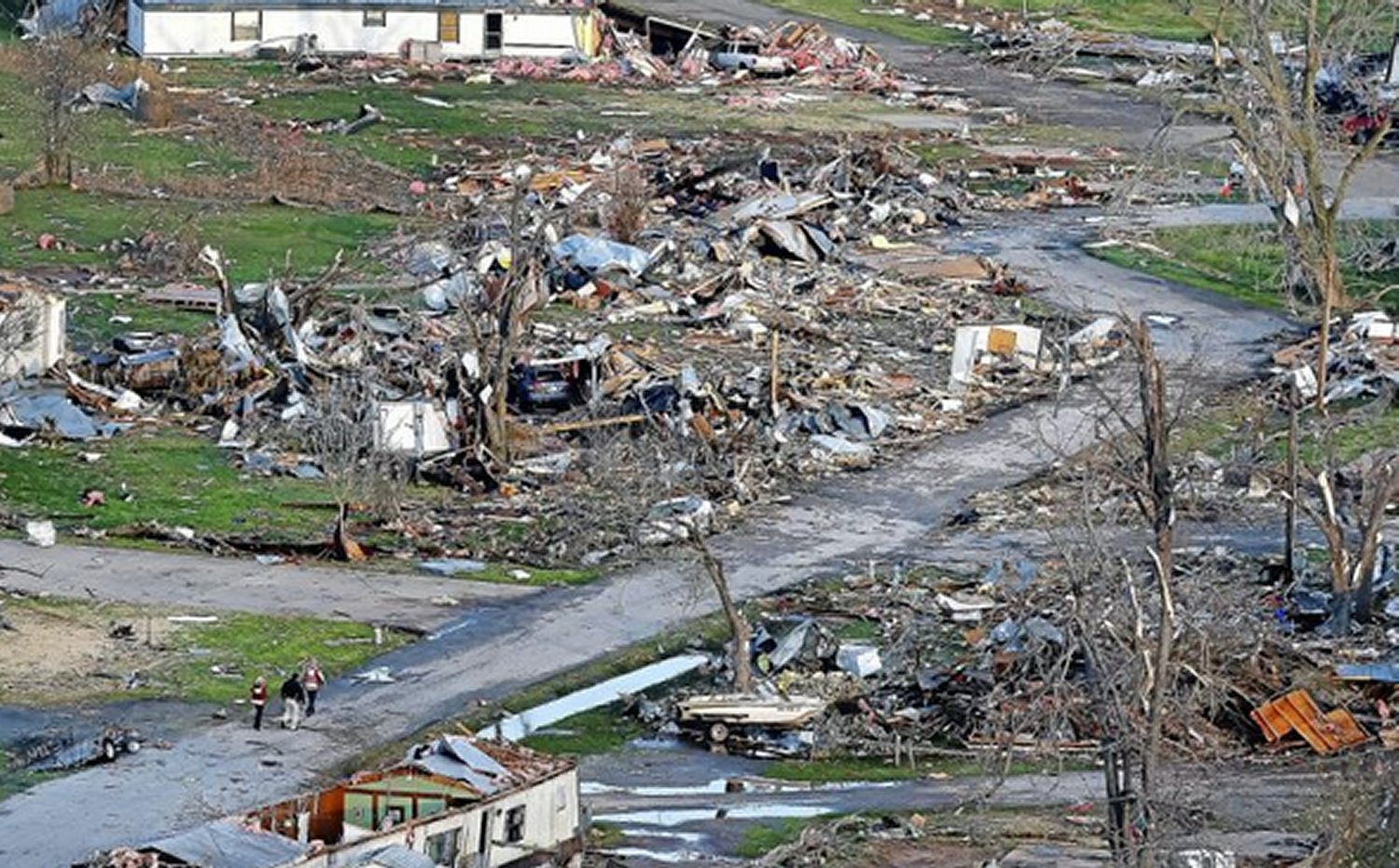
As expected, several storms initiated on Wednesday afternoon and grew into supercells. Two supercells were of most concern before storms consolidated into squall lines: one near Tulsa and one near Oklahoma City. The storm that approached Tulsa showed strong rotation on radar early in its lifetime –a tornado warning was able to be issued well before it hit the city. By the time it reached a suburb of Tulsa, Sand Springs, a tornado touched down and tore through a trailer park. In addition to that, hail, the size of tennis balls, were reported in Tulsa’s metro region as the supercell’s hail core passed over the city. The tornado (preliminary rating of EF-2) injured over a dozen people and one person lost their life in the trailer park.
Aerial view of the damage to the trailer park in Sand Springs. (Source: Tulsa World)
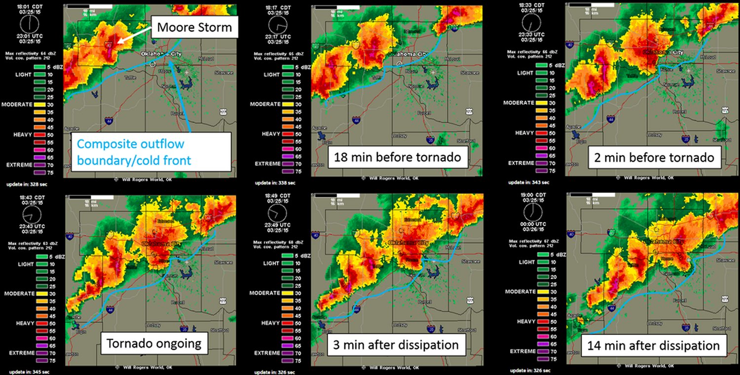
The Oklahoma City storm fired off the dryline initially but then got undercut by the cold front – meaning it had little tornado potential. Interestingly enough, the supercell was able to catch up to the cold front and interact with it, enhancing the vorticity in the area – likely being a contributing factor to the formation of the tornado. With this mesoscale interaction playing a significant part in the cause of the tornado, not much lead time was provided to residents (it happened quickly). Unfortunately the twister (preliminary rating of EF-1) touched down in the city of Moore, OK which got hit by a devastating twister in 2013 and had seen two other strong tornadoes since 1999. No injuries were associated with this one, thankfully.
Compilation of radar images before/during/after the Moore tornado showing the storm’s interaction with the cold front. (Image compilation by @VORTEXJeff / Twitter)
The pattern could become active again by the middle of next week, but it is still too early to be certain. April to late May is typically the busiest time of the year for severe weather in the Southern US Plains, due to plentiful moisture before the jet stream shifts further north for the summer.
The brief cool-down in the wake of a relatively short-lived, but potent storm will come to an end this weekend thanks to another low pressure system moving across the Prairies that will bring a warm front across the province over the next couple days.
Friday
-1°C / -7°C
Mainly cloudy with a chance of flurries
Saturday
7°C / 1°C
Increasingly cloudy & windy
Sunday
7°C / -2°C
Clearing & windy
Today will see cloud moving in through the morning as a weak disturbance moves into western Manitoba. While this system will bring 2–4cm of snow west of the Red River Valley, here in Winnipeg we’ll see just a slight chance of a light flurry or two. Further west in the Red River Valley – near Portage la Prairie S/SE down towards Morden & Winkler – will likely see a bit of light snow today, but no significant accumulations from it. Winds will be around 20km/h or so out of the south and Winnipeg will see a high temperature near –1°C. Skies will clear this evening as temperatures head to a low near –7°C.
Saturday will be a warm but windy day as a warm front moves into the Red River Valley. Temperatures will climb to an above-normal[1] 7°C under increasingly cloudy skies. Winds will pick up fairly early in the day and strengthen out of the south to 40–50km/h.
Saturday Night
1°C
Rain overnight
A low pressure system will track through Manitoba on Saturday night. The biggest impact from this storm will be felt in Central and Northern Manitoba where up to 10cm of snow may fall. Further south, we’ll see an area of rain move across the region beginning early Saturday evening and tapering off sometime mid-overnight.
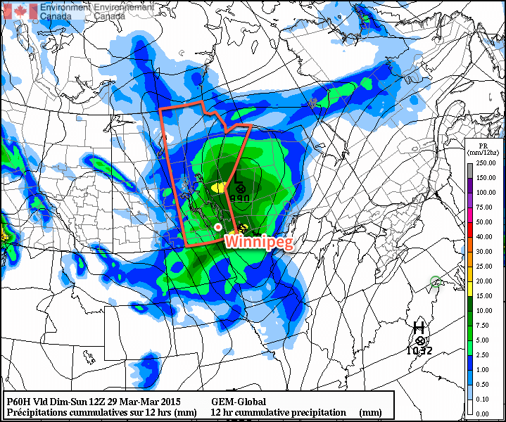
Generally speaking, somewhere between 2–5mm of rain is likely to fall. Winds will taper off in the evening as the Red River Valley moves into the trough of this system, and then pick up again out of the northwest once the low passes. The wind will likely strengthen to around 40km/h by Sunday morning.
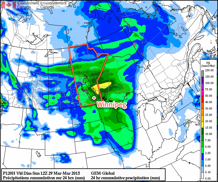
12hr. accumulated precipitation amounts forecasted by the GDPS for Saturday night.
Sunday will see clearing skies and a high once again near 7°C. Winds will remain strong out of the northwest at 40–50km/h into the early afternoon before tapering off.
Long Range
The long-range forecast looks quite nice through the first half of next week. Both Monday & Tuesday look to bring fairly sunny skies and highs somewhere in the 5–10°C range. Things take a bit of a turn mid-week when a low pressure system is forecast to move across the Prairies and potentially bring another snow event to the Red River Valley.
Normal daytime highs for this time of year in Winnipeg are near +3°C. ↩
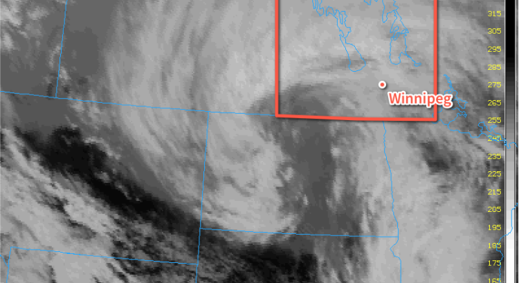
A potent spring storm is moving into Manitoba today and will likely exit the region known as one of the strongest of the Winter 2014/15 season. This storm has already brought drizzle, rain and freezing rain to southwestern Manitoba & the Red River Valley and will end up delivering the whole wintery mix by the time all is said and done. Environment Canada has issued a swath of heavy snowfall warnings and special weather statements across Manitoba in advance of this system.
Tuesday Night
Tuesday Night
-1°C
Rain changing to snow
Rain will redevelop this evening and persist through much of the overnight period until a cold front pushes through the Red River Valley and switches the precipitation over to snow. Many areas in the Red River Valley will see around 5-10mm of rain. Alongside the switchover to snow, strong northwesterly winds to 40-50km/h with gusts as high as 70km/h will begin to move into the Red River Valley. The combination of falling snow and strong winds, coupled with the temperature dropping below zero overnight after a day of melting, drizzle & rain will likely produce very poor driving conditions with slippery roads & poor visibilities in blowing snow by Wednesday morning.
Wednesday
Wednesday
⇒ -2°C / -11°C
Snow ending in the afternoon; windy
Snow will continue through Wednesday morning before beginning to taper off through the afternoon with a further 5-10cm possible for the City of Winnipeg and the Red River Valley. As mentioned before, the snow will be accompanied by strong northwesterly winds to 40-50km/h which will produce a fair amount of blowing snow as well. Temperatures will drop just barely to -2 or -3°C through the day. Given the relatively mild temperatures, it’s quite likely that as soon as the snow begins to taper off, the blowing snow will too; falling snow will be needed to produce it and it’s unlikely we’ll see much ground-based blowing snow after the fact. Winds will begin to taper off late in the afternoon or in the early evening as the storm moves off into Ontario. Left behind the storm will be partly cloudy skies as temperatures drop to around -11°C.
Storm Update
As expected, many regions across Manitoba saw a significant dump of snow overnight and into this morning. Snowfall totals to 10:30AM CDT across Manitoba are:
Location
Snowfall Amount
Winnipeg
5cm
Portage la Prairie
5-10cm
Brandon
6cm
Steinbach
5cm
Dauphin
15-25cm
Rossburn
20cm
McCreary
18cm
Neepawa
15cm
Fisher Branch
15cm
Roblin
14cm
Elkhorn
10cm
Argyle
10cm
Swan River
8cm
Miami
6cm
Morris
2cm
In addition to the heavy snow, many areas through the Red River Valley saw several hours of rain last night. Here in Winnipeg, around 8mm fell overnight, and preliminary reports indicate that similar amounts were seen through much of the Red River Valley. In addition to the snow and rain, very strong winds to 50-60km/h moved into Red River Valley this morning producing blowing snow and helping make sure roads are slick.
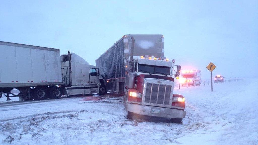
Two semi-trucks were involved in a MVC 5km east of Elie. (Credit: @HeatherWellsCBC)
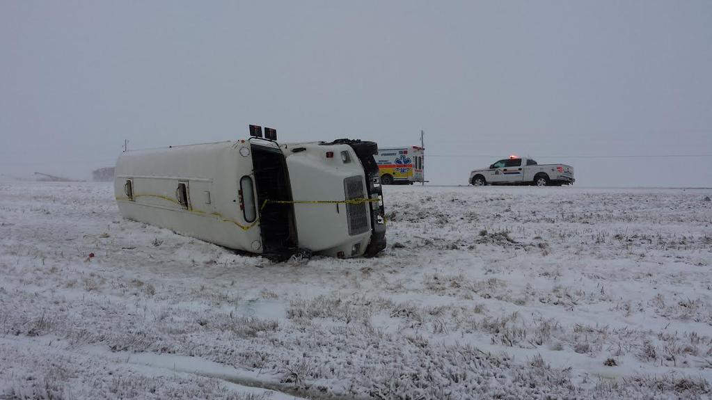
A school bus rolled on Highway 75 near St. Adolphe this morning. (Credit: @HeatherWellsCBC)
The winter weather has wreaked havoc on area infrastructure with numerous accidents on highways as well as complications to power infrastructure with numerous pole fires & power line damage events reported. Many motor-vehicle collisions were reported on Manitoba Highways, with several resulting in sections of Highways 1 and 75 being closed. Two of the more significant ones, pictured above, involved a jackknifed semi-truck collision near Elie and a school bus rollover near Ste. Agathe on Highway 75.
Conditions have begun to improve in the Red River Valley; winds remain strong however with the snow finally moving off into Ontario, much of the blowing snow has stopped. Road conditions will continue to be poor through the remainder of the day, so if you are driving, especially on area highways, be sure to give yourself extra time and be cautious.
Thursday
Thursday
-6°C / -11°C
Partly cloudy
Thursday will be a mainly sunny day – perhaps just a few lingering clouds – with a cool high of just -6°C. Winds will be light, so with the increasingly strong March sun it may not actually feel all that bad outside. Even with the sub-zero temperatures, expect plenty of melting to happen. We head into Thursday night with clear skies and cool off to around -10 or -11°C again overnight, although that could be a couple degrees warmer depending on when cloud cover arrives from…
Friday
Friday
-3°C / -8°C
Mainly cloudy with a chance of light snow
Friday will bring mainly cloudy skies as clouds push in either early Friday morning or late overnight on Thursday thanks to a system rippling through Southern Manitoba from the northwest. It will most likely produce a band of snow through portions of the Parkland, Southwest and into the Western Red River Valley. Under this band, accumulations of 1-2cm look possible at this time. There’s a little uncertainty as to the exact track, given that it’s 3.5 days out at this point, so it may end up a little further west or east. With the current “most likely” track, Winnipeg sees a fairly decent chance at some flurries but little in the way of accumulations. Temperatures will climb to around -3°C with fairly light winds. Friday night looks pleasant with light winds again and a low near -8°C.
Long Range
It’s looking as if another storm is possible on Saturday night as a shortwave tracks across Manitoba.
The GDPS is forecasting a fair amount of precipitation associated with a significant storm moving through Manitoba this weekend.
Fortunately, it seems like it will be bringing enough warm air with it that precipitation would fall as rain. Either way, though, it looks like we’ll see plenty of cloud and wind this weekend. After a long spell of little in the way of weather, it looks like a typical, more active springtime pattern is setting up!