Cool Weather Continuing, but Hope on the Horizon

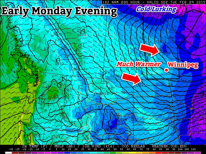
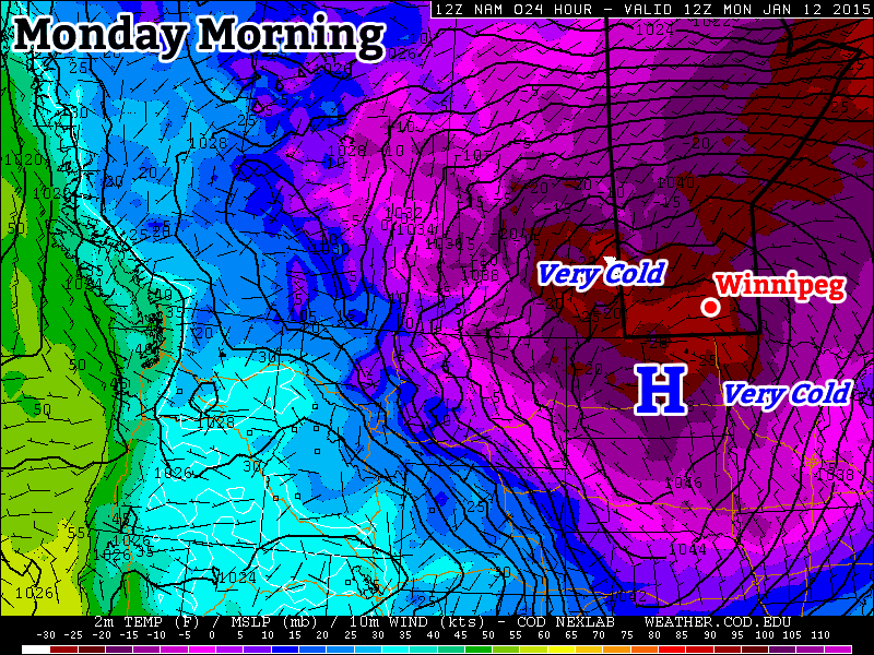
The next few days will see cool weather continuing as yet another Arctic high pushes through the region. It’s not all bad news, however, as it seems like we may see a brief break from the cold this weekend into the beginning of next week as the coldest core of air pushes off to our east.

Wednesday
-18°C / -27°C
Gradual clearing with a chance of flurries

Thursday
-16°C / -24°C
Mainly sunny

Friday
-12°C / -20°C
Mainly sunny

Today will start off with mainly cloudy skies and see gradual clearing as the day progresses. Temperatures will warm up to around -18°C with a chance of some flurry activity through midday into the afternoon. Winds will strengthen to around 30km/h this afternoon ahead of the incoming Arctic ridge. Skies will clear through the evening as the temperature heads to a low near -27°C.

Thursday and Friday will be quiet, cool days with highs near -16°C & -12°C respectively and mainly sunny skies.

Warmer Weather on Tap For The Weekend

As mentioned above, a brief reprieve is in store through the weekend into early next week as warmer temperatures work into the region. Highs look to sit near -10°C on Saturday and Sunday with some flurry activity possible on Sunday. Monday may see even warmer temperatures climbing towards the -5°C mark.

NAEFS 8-14 Day Temperature Anomaly Outlook

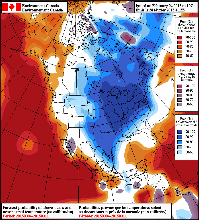
Heading further into next week it looks like the cold weather will return. The NAEFS 8-14 day temperature anomaly outlook shows a high probability of below-normal temperatures returning to the region.

Warm Monday, then Arctic Air Returns

We’ll see warm weather to start the week before arctic air quickly returns for Tuesday.

Today will be significantly warmer than the weather of the past several days

Monday

Monday
-1°C / -16°C
Flurries

Today will be the warmest day of the week and the warmest day we’ve seen in awhile. Temperatures will be around the freezing mark by late in the day as a milder western flow moves across southern Manitoba. That westerly flow will be quite brisk as winds reach 40km/h gusting to 60km/h. We’ll also see some light flurries during the day, although accumulations will be small.

Tuesday

Tuesday
-14°C / -26°C
Mainly Sunny

Tuesday will be a cooler, but less windy day. High temperatures will be in the mid minus teens with a breezy north-west wind. Skies should be fairly sunny, so overall conditions won’t be too bad.

Wednesday

Wednesday
-19°C / -30°C
Mix of sun and cloud

Wednesday will see temperatures drop further as another arctic high builds in from the north. High temperatures will be around the -20C mark, with variable skies. There will be a slight chance of flurries due to some low-level instability, but they will be very hit and miss.

Long Range

The long range forecast continues to look very cold. A series of high pressure system will continue to drop down from the north, bringing continued bursts of arctic air. On a happier note, meteorological winter is almost over, so we can only go up from here!

Mild & Cloudy Weather Ahead

The warmer weather has finally made its way to Manitoba with temperatures expected to climb well above normal today. The surge of warmth is thanks to a weak low pressure system pushing through the Interlake today which also bring some light snow to Southern Manitoba today. Above-normal temperatures will persist through the remainder of the week in what will be a very pleasant mid-January break from the cold.

Wednesday

-3°C / -8°C
Snow beginning this morning.

Thursday

-5°C / -18°C
Mixed skies with a chance of flurries.

Friday

-5°C / -8°C
Mainly cloudy, light snow likely

Today’s weather will be driven by a low pressure system tracking through the Interlake region. Light snow will spread eastwards across Southern Manitoba through the morning period with most areas seeing the snow taper off by mid-afternoon. Generally, a couple cm of snow is expected, however slightly higher amounts of 3–4cm may fall through the Interlake. Winds will be gusty out of the south at 30–40km/h until the evening when the winds will diminish and shift to the southwest. Expect a high near –3 or –2°C today.

This 12hr. precipitation totals panel from the RDPS shows 1-2.5mm of precipitation over Manitoba today, equivalent to anywhere from 1 - 3cm of snow.
This 12hr. precipitation totals panel from the RDPS shows 1–2.5mm of precipitation over Manitoba today, equivalent to anywhere from 1 – 3cm of snow.

The clouds may break up a bit overnight, however it should remain on the mostly cloudy side. Our low temperature will fall to around –8°C.

Thursday will bring mixed skies and a slight chance of flurries as a weak frontal boundary works through the Red River Valley. Highs will sit near –5°. Skies should clear out on Thursday night, allowing temperatures to drop significantly to around –18°C for a low.

More cloud returns on Friday as another low pressure system works into the province. Not much snow is expected with it, but light snow over much of Southern Manitoba looks likely. Highs will climb to around –5°C with lows on Friday night at around –8°C.

The milder, somewhat cloudy weather is expected to persist through the weekend before returning to more seasonal values[1] for next week.


  1. Normal daytime highs are around –13°C for this time of year in Winnipeg.  ↩

Warm-up Just Around the Corner

After a couple weeks of frigid conditions, a warm-up is on the way. However, we’ll have to deal with another couple days under an arctic air mass before warmer weather arrives.

Monday morning will be extremely cold in southern Manitoba

Monday

Monday
-22°C / -26°C
Mainly Sunny

Today will be very cold in southern Manitoba. Morning low temperatures will be in the minus thirties, with daytime highs remaining stuck in the minus twenties. The wind will gradually pick up throughout the day, slowly adding a more significant wind chill factor. We’ll be under a strong surface high pressure system, so at least it will be sunny!

Tuesday

Tuesday
-18°C / ⇑ -15°C
Mainly Cloudy

Tuesday will be the last really cold day for awhile. Morning temperatures will be in the minus twenties, with a gusty south wind, making it feel closer to -40. Temperatures will slowly rise during the day, reaching the upper minus teens by late in the day. The wind will remain gusty though, so it will still feel pretty cold. However, temperatures will continue to rise on Tuesday night as that southerly flow brings in warmer air, setting up much nicer weather for Wednesday.

Wednesday

Wednesday
-2°C / -10°C
Mainly Cloudy

Wednesday will finally feature that long-promised warm-up. Temperatures will climb into the low-minus single digits (maybe even up to 0C in some areas). Unfortunately, it will be a cloudy day, but I’m sure most people will take the warmer conditions over a bit of sun.

Long Range

The long range forecast continues to show a prolonged period of warmer weather beginning this week. The average high at this time of year is -13C, so that does not mean every day will be near the freezing mark, but most days should be in the minus single digits.