Warm Weather Continues

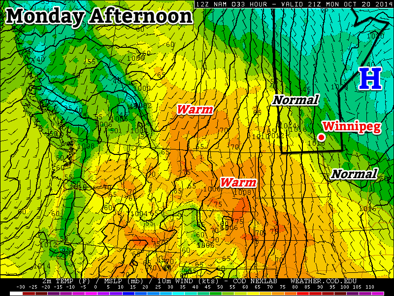
Above-normal temperatures[1] will continue through the remainder of the week as a southwesterly flow aloft continues to pump relatively mild Pacific air over the Prairies.

Wednesday
17°C / 8°C
Increasing cloud with a chance of showers

Thursday
15°C / 7°C
Mainly cloudy

Friday
16°C / 5°C
Some morning cloud, then sunny

Unsettled Wednesday

Today will be the most unsettled day of the week thanks to a (very) weak cold front pushing eastwards across the Red River Valley today. A fairly sunny start to the day will become more mixed by mid-day with a slight chance of shower activity in Winnipeg mid-day into the early afternoon. It seems most likely that the activity will remain to the east of Winnipeg, with showers or even thunderstorms almost a certainty in the Whiteshell southwards to the US border.

Precipitation forecast for this afternoon from the Canadian RDPS model.

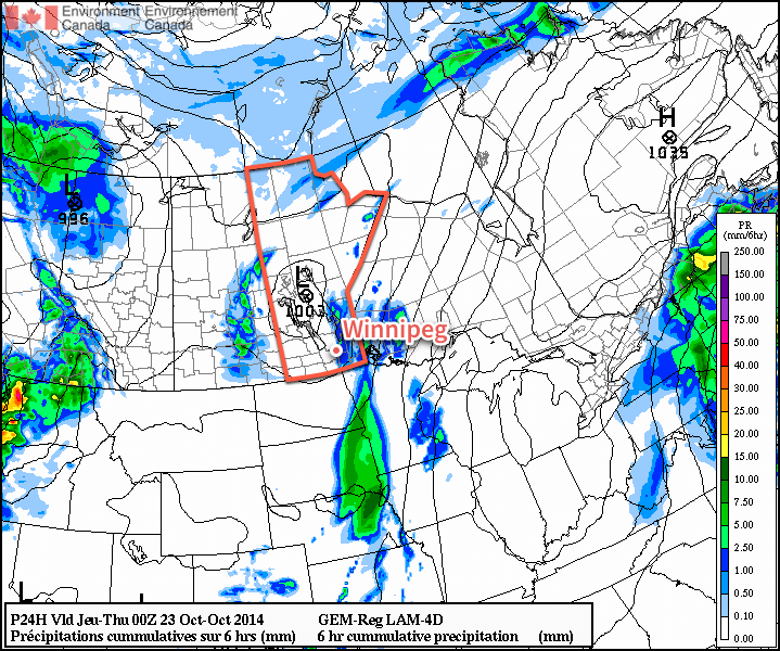
The American NAM weather model has been an outlier for several runs in a row, producing a fairly potent band of showers and thunderstorms over the western Red River Valley and pushing eastwards through the day. Given the weak surface forcing, mediocre moisture and the rate and evolution of the upper-level destabilization, it seems that the NAM is probably over-doing things and not a likely forecast. It’s worth mentioning here as an outside possibility, though, given its consistency in producing that outcome.

Other than the showers, strong southerly winds at 40 gusting 60km/h will taper off this afternoon behind the weak cold front as they shift to westerly at around 20km/h. The temperature will climb to around 17°C today.

Skies will clear out this evening as the temperature drops near 8°C for the overnight low.

Pleasant End to the Week

Thursday and Friday will both be pleasant fall days – especially for late October. Dry weather will be the name of the game for both days with highs in the mid-teens and fairly light winds. Some cloud will push across the Red River Valley on Thursday night but otherwise things will be mainly sunny/clear. The temperature will dip to around 6 or 7°C on Thursday night and a bit cooler – near 5°C – on Friday night.

Heading into the weekend, the weather continues to look pleasant with highs in the teens, no real threat of rain and plenty of sunshine. Enjoy!


  1. Normal daytime highs for this time of year sit around the 8°C mark.  ↩

Above-Normal Temperatures to Start the Week

More above-normal weather is in store to start the week – what’s not to like!

Temperatures on Monday will be near normal in Southern Manitoba

Monday

Monday
11°C / 3°C
Mainly Sunny

Today will see near normal temperatures in southern Manitoba. Highs will be around or just above 10C with mainly sunny skies. Winds will be light, making for pleasant conditions overall.

Tuesday

Tuesday
17°C / 8°C
Mainly Sunny

Tuesday will see above-normal conditions return to southern Manitoba. Temperatures will be in the mid to upper teens with skies remaining mainly sunny. A strong south-east wind will be in place throughout the day, putting a bit of an edge on what would otherwise be a very nice day.

Wednesday

Wednesday
16°C / 8°C
Mainly cloudy with chance of showers

Warm weather will continue on Wednesday, with temperatures remaining in the mid teens. A weak low pressure system is expected to pass through southern Manitoba during the day, possibly producing some showers in its vicinity. This system will also likely bring in some heavier cloud cover, so Wednesday probably won’t be as sunny as Monday and Tuesday.

Long Range

Long range modelling suggests that above-normal weather [1] will continue through the end of October. That doesn’t mean that every single day will be warmer than normal, but the majority should be. Enjoy the pleasant end to October!


  1. Normal highs for the last stretch of October sit around 9°C.  ↩

Elsewhere in Weather News: October 18th, 2014

Gonzalo Rolls through Bermuda

Another week, another tropical disturbance forms – this time in the Atlantic. Gonzalo started to organize earlier this week just east of the Caribbean and drifted west, slowly organizing itself at the same time. By the time it reached the eastern islands of the Caribbean such as Anguilla and the British Virgin Islands, Gonzalo was a category one hurricane and brought strong winds and heavy rains to the islands. Hurricane Gonzalo then started curving northeast and quickly strengthened into a category four, with a pinhole eye after it cleared the Caribbean Islands. The storm was then headed for Bermuda, which meant trouble for the small island out in the Atlantic.

Deep convection in the northern eye wall of Gonzalo depicted by the black colors. Bermuda is identified by the white arrow.

Gonzalo made landfall on Bermuda Friday evening, lashing Bermuda with high end category two winds (175km/h) as the eye wall made its way across the island. Reports of how Bermuda fared were difficult to find as of Friday evening, but it appears the island did quite well with no deaths or injuries reported. However, power was knocked out to about 90% of Bermuda’s residents as well as flooded streets reported. Compared to last week’s EIWN, the big difference is that the infrastructure in Bermuda is built to withstand fairly strong hurricanes, unlike most of the buildings in the region of India that Hudhud affected.

The Bermuda Weather Service launched a weather balloon as the eye approached Bermuda at 00z. (Source: University of Wyoming)

Hurricane Gonzalo will continue its trek northeastwards and may even clip Newfoundland by Sunday as it transitions to extratropical. Interestingly enough, Gonzalo will likely make it all the way to the United Kingdom as an extratropical storm early next week. No other storms are expected in the near future in the Atlantic.

Near-Seasonal Temperatures Return for the Weekend

Cooler temperatures have moved into Southern Manitoba behind a low pressure system that brought a few showers and strong northerly winds as it moved across the Red River Valley yesterday evening. Today will be a cool, dreary return to chilly fall weather, but a gradual moderation of temperatures is in store for the remainder of the weekend.

Friday
7°C / 0°C
Cloudy; chance of drizzle or showers

Saturday
10°C / 6°C
Mainly cloudy

Sunday
14°C / 3°C
Mainly sunny

A less-than-pleasant day is in store for Winnipeg today as breezy northerly winds around 30km/h continue to push a cool air mass southwards into the Red River Valley, leaving us with a dreary day with a high barely above where it starts the day off at. The temperature will struggle to climb to 7 or 8°C today under cloudy skies alongside a slight chance of drizzle or shower activity. Skies will remain mainly cloudy tonight with a chance of a few clear breaks late overnight; the temperature will drop to between 0–2°C for the overnight low.

This animation of 850mb temperatures (running from Friday evening to Saturday evening) shows warmer air pushing eastwards into Manitoba.

There isn’t too much to say about the weekend other than conditions will gradually improve. Saturday looks fairly cloudy with a high near 10°C and light winds. A partly cloudy night will see the temperature dropping to 6°C or so. Sunday will be quite a pleasant day with temperatures climbing back above normal under mainly sunny skies. Expect a high near 14–15°C and an overnight low on Sunday night near 3°C. At this point, it does look like a low pressure system will move through the Interlake on Sunday, bringing some showers along with it. Current indications are that all of that activity will remain to the north and east of Winnipeg, but we’ll keep an eye on it as the system develops.

Heading into next week looks very nice with temperatures returning to the upper teens as another upper-level ridge builds into the Prairies, spreading mild Pacific air eastwards once again.