Gradual Improvement In Store

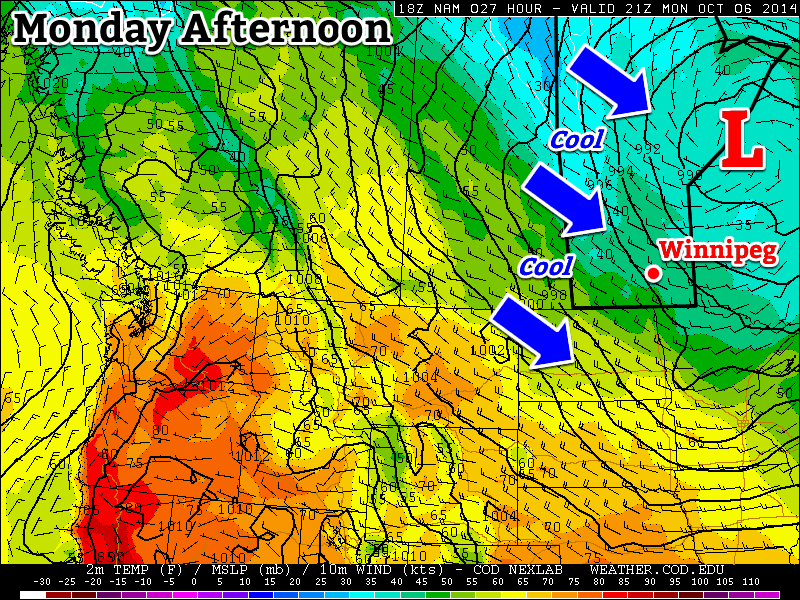
The weather will ever so slowly improve in Winnipeg over the next few days as the persistent low pressure system over Northern Ontario that has kept us locked in a cold northwesterly flow over the past several days begins to weaken and move off to the north. It will be a slow process, though, so for now hope will sit right on the horizon while Winnipeggers work through a few more cool days.

Wednesday
7°C / -2°C
Cloudy with sunny breaks

Thursday
8°C / 1°C
Mainly cloudy

Friday
10°C / 1°C
Mainly sunny

Gradual warming will take place over the next few days as a ridge of high pressure slowly works its way into the province from the northwest, bringing with it not warmer air, but sunshine, which should help things get warmer than they have been over the past few days. Today, though, will see gusty northwesterly winds and intermittent sunny breaks in what will otherwise be a fairly cloudy day. The temperature should climb to around 6 or 7°C, although it will likely be slow-going in getting to that point. Clearer skies tonight will bring a low around -2°C with frost.

Tomorrow will be another mainly cloudy day as more cloud moves into the Red River Valley from the Interlake in our northwesterly flow. Temperatures may end up a tad bit warmer than today at 7 or 8°C and winds will ease off a little bit. Skies should clear tomorrow night with a low near 1°C.

Friday will be the first “nice” day seen in a while for Winnipeg; mainly sunny skies, light winds and a high near 10°C will break our spell of cold, windy and cloudy weather. Temperatures will drop to around the 1°C mark again on Friday night.

Warming for Thanksgiving Weekend

Warmer weather is on the way, however, for the weekend. A large low pressure system will drag warmer air into the province, helping highs climb into the mid-teens for both Saturday and Sunday. Skies are looking sunny for Saturday with mixed-to-cloudier skies on Sunday, but no precipitation is expected. Things may turn more unsettled on Monday as a low pressure system moves through the Interlake, but it’s too far out at this time to really say much for certain. We’ll have a full look at Thanksgiving weekend on Friday morning!

Cool Weather Continues

A large upper-level low pressure system over northern Ontario will bring us chilly weather to start the week. Unfortunately, this means below-normal temperatures and frequent opportunities for showers.

 An upper low over Ontario will bring cool conditions to southern Manitoba this week
An upper low over Ontario will bring cool conditions to southern Manitoba this week

Monday

Monday
7°C / 2°C
Mainly cloudy with chance of showers

Today will be cool, cloudy, and breezy as that large upper-level low over Ontario brings a cool north-westerly flow to southern Manitoba. There will be a chance of showers throughout the day, as a band of light precipitation pushes down from the north.

Tuesday

Tuesday
7°C / -1°C
Mainly cloudy

Tuesday’s weather will be very similar to today’s. Skies will once again be mainly cloudy with a chance of showers. Unfortunately, it will also remain breezy as that upper low to our east maintains a decent pressure gradient across Manitoba.

Wednesday

Wednesday
8°C / -3°C
Mix of sun and cloud

It looks like Wednesday’s weather may begin to see some improvement over the conditions from earlier in the week. Temperature won’t warm by much, but winds should be a bit lighter. The chance for showers looks to be gone on Wednesday, and we should even see some sunshine.

Long Range

The long range forecast isn’t looking all that great at this point. The current forecast calls for a surface high to build into Manitoba late this week as that nasty upper low finally moves off. This will likely mean sunnier skies, but also a good chance for some solid freezing nights, and relatively cool daytime temperatures. Models hint at a warming trend from next weekend into the following week, though it isn’t currently expected to be an extended warm-spell…but we shall see what actually happens!

Elsewhere in Weather News: October 4th, 2014

Strong Typhoon Expected to Clip Japan

A strong typhoon dubbed Phanfone spun up in the Northwest Pacific this past week and has significantly strengthened since then. Phanfone, which is currently a strong typhoon bearing winds of 195km/h with a central pressure of 935mb is unlikely to make a direct landfall on the main islands of Japan, unless its tracks shifts slightly north. Even if it does not make landfall it is still expected to bring significant severe weather to the region, including Tokyo. The typhoon which is currently heading directly north is expected to start curving northwest today, helped by prevailing winds. As this happens gradual weakening is expected, however, it’s forecast that at its closest point to Tokyo on Sunday the storm will still have sustained winds of 120km/h, likely bringing tropical storm force winds to Tokyo. These winds, combined with the storm surge and heavy rainfall are likely to cause damage, especially in the mountainous regions that are prone to landslides. In preparation for this storm the Japan Meteorological Agency has issued storm surge advisories and high wave warnings for several coastal communities.

IR image of typhoon Phanfone on Friday night at 05z with intensity/track overlaid. (Source: CIMSS)
IR image of Phanfone on Friday night at 05z with intensity/track overlaid. (Source: CIMSS)

Another tropical disturbance that spun up only a few days ago in the Pacific is also the focus of attention this week, even though is not expected to make landfall on any regions any time soon. Vongfong is only a tropical storm currently, but is organizing and is under fairly good conditions for typhoon strengthening. China, Japan and possibly Taiwan will have to keep an eye on this storm by the end of next week but it is still very early to focus in on any specifics for this storm. The storm is expected to make its way through Guam however, as a typhoon, late this weekend.

Another Cold Snap in Southern Manitoba

Moderately miserable, categorically cold; the weather leading into this weekend will be fairly miserable as a large low pressure system moving through Ontario exerts its influence over southern Manitoba causing strong northwesterly winds as the coldest shot yet of Arctic air plunges southwards into the United States.

Friday
5°C / -1 to 2°C
Cloudy with showers. Flurries possible in the morning. Strong NW wind to 50km/h.

Saturday
7°C / 0–2°C
Clearing except cloudy in the lee of the lakes

Sunday
9°C / 3°C
Mixed skies with a slight chance of isolated showers or drizzle

Friday: A Miserable Fall Storm

The Red River Valley will be under the grip of a miserable fall storm lifting northwards through Northern Ontario today, driven by a massive push of cold Arctic air sweeping through Manitoba. We’ll see a very cold start to the morning with temperatures hovering around 2–3°C, strong northerly winds at 40–50km/h with gusts as high as 70–75km/h and a band of rain stretching north-south through the region. Embedded within the band will likely be some convection, significant since increased precipitation intensity could mean that in addition to the rain, we might see brief bursts of snow as well.

The precipitation should taper off by early afternoon, but we’ll still be left with a strong northerly wind and temperatures struggling to get to our high of 5°C. If the sun manages to poke out at all, we may eke out a 6°C for a high, but that looks quite unlikely.

The RDPS clearly shows Winnipeg nestled between two bands of lake-effect precipitation on Friday night.

Winds will begin to taper off tonight to around 20km/h. Combined with the cold air, the lake-effect machine will likely start up again, producing lake-effect showers or snow through the overnight period across regions in the lee of the lakes. At this point it looks like Winnipeg will remain safely between the two bands of lake-effect precipitation. The overnight low will be anywhere from –1 to 2°C, depending on exactly how much cloud remains in the area. Here in Winnipeg we should end up on the colder end of things under clearing skies.

A Chilly Weekend

It will be a chilly weekend in Winnipeg with temperatures on Saturday and Sunday both climbing only into the mid-to-upper single digits. Saturday should be a fairly nice day with mainly sunny skies in Winnipeg, but just to our west and east, lake-effect cloud (and likely precipitation) will be ruining a few people’s day. Temperatures will dip to the 0 to 2°C range Saturday night with just a few clouds. Again, lake-effect cloud will be present in the lee of the lakes.

Sunday will bring mixed skies as the whole storm system begins backing into Northern Manitoba from Ontario. Rain or snow will push through Central Manitoba into the Interlake through the day, spreading cloud ahead of it. Winds don’t look too bad this time – only around 20–30km/h – and precipitation should hold off in Winnipeg until overnight. Temperatures will drop to around 3–4°C on Sunday night, heading into a cool and showery Monday.