Another Storm on the Way

Wednesday will be a brief reprieve from the showery weather before a fairly potent low pressure system spreads more rain & thunderstorm activity across Southern Manitoba tonight into tomorrow morning and brings dreary weather for Thursday with strong northwesterly winds.

Wednesday
23°C / 13°C
A few sunny breaks; rain overnight.

Thursday
19°C / 6°C
Rain and drizzle tapering off mid-day. Risk of a thunderstorm. Windy.

Friday
19°C / 5°C
Mainly sunny.

Today will be a fairly pleasant day with mostly cloudy skies and a high near 23°C or so. There’s a slight chance of an isolated shower or three through the Red River Valley, including Winnipeg, but for now it looks like the activity should mainly remain to our west over southern Saskatchewan and southwest Manitoba.

Tonight, an inverted trough extending NW from a low pressure system moving through the Dakotas will spread rain with the risk of thunderstorms eastwards into the Red River Valley. Rain will likely start sometime after 1AM and persist until mid-morning Thursday. The temperature will dip to around 13°C.

The Canadian RDPS is one of the models rather bullish on higher precipitation amounts Wednesday night.

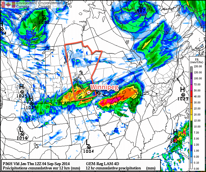
Rainfall totals for tonight are still uncertain; the general agreement is for between 10–20mm, however if substantial elevated convection develops as much as local amounts of 40–50mm may be possible. The low end of precipitation forecasts produce only around 5mm of rain.

I feel fairly comfortable with 10–20mm of rain tonight, but we’ll reassess the elevated convection potential later today and update if necessary. We’ll try and have an update fairly early this afternoon.

Unpleasant Thursday

Thursday will be quite an unpleasant day as Winnipeg moves onto the back side of the low pressure system lifting northeastwards into Ontario. The bulk of the rain should taper off mid-day, but brisk northwesterly winds building to 30–40km/h will accompany cloudy skies and a high struggling to climb into the upper teens. It’s also fairly likely drizzle will persist after the main area of rain moves out, making for a generally dreary day.

Skies will clear out for the evening, although there may be some cloudy periods through the first half of the night with some cloud moving off of Lake Manitoba, and temperatures will drop to a chilly 5 or 6°C.

Fall-Like Friday

Friday will be fairly pleasant, albeit cool, with mainly sunny skies and a high near 19 or 20°C. Winds will be fairly light through the day.

Friday night should bring clear skies and a low near 5 or 6°C.

A Look Ahead to the Weekend

The upcoming weekend is looking fairly good with unpleasant weather staying to our north. It’s looking like plenty of sun is in store with daytime highs in the ballpark of the seasonal 21°C mark and overnight lows moderating by the end of the weekend.

Plesant End to the Long Weekend

This week will start off with pleasant conditions, as we experience a nice end to the long weekend.

Labour Day will be pleasant in southern Manitoba

Monday

Monday
23°C / 8°C
Mix of sun and cloud with a chance of showers or thunderstorms

Today will be a pleasant day in southern Manitoba. Temperatures will be in the low to mid twenties with a light westerly wind and partly sunny skies. There will be a slight chance of showers or thunderstorms, but any rain should be isolated and short-lived. Overall, it will be a good end to the last long weekend of summer.

Tuesday

Tuesday
24°C / 10°C
Mix of sun and cloud with a chance of showers or thunderstorms

Tuesday will be another nice day in southern Manitoba. Skies will be a mixture of sun and cloud, with temperatures in the mid twenties. There will once again be a slight chance of showers or thunderstorms, but they’ll again be isolated.

Wednesday

Wednesday
24°C / 13°C
Mix of sun and cloud

Wednesday will once again feature seasonably warm conditions in southern Manitoba. High temperatures will be in the low to mid twenties with light winds.

Long Range

The long range forecast is a bit uncertain at this time. It looks like we’ll generally see near seasonal conditions in the short to medium term, which means temperatures in the lowish twenties. There will however be some days warmer, and some cooler, than seasonal values.

Elsewhere in Weather News: August 30th, 2014

Montana Sees Unusual August Flooding

The same strong low pressure system that brought 20–40mm to the Red River Valley last weekend brought significant rainfall to parts of central and eastern Montana. These extreme rainfall events in August are uncommon for Montana as strong systems usually stay well north with the polar jet stream and wildfires are typically the concern around this time of the year.

Storm total rainfall for parts of central and eastern Montana (in inches). (Source: NWS Glasgow)

The deep low pressure system brought heavy rain (with a few breaks) to the region between August 21st and the 24th. Combined with abnormally high Precipitable Water values (PWAT) in the region, this made for high rainfall totals throughout the region. Storm total reports between 175mm and 200mm were not uncommon. Glasgow, MT saw around 145mm fall through the event (Aug. 21–24) which is four and a half times their monthly average rainfall for the whole month of August. In comparison to last year, they had less than a quarter of their monthly average rainfall by this time.

Milk River near Glasgow reached major flood stage Monday and Tuesday. (Source: NWS Glasgow)

Many rivers in the regions quickly swelled up and spilled their banks including the Milk River which entered major flood stage near Glasgow on Monday. Mudslides also became a concern in the more mountainous regions. It appears that most of the damage due to the flooding occurred to roads and culverts, however some homes were damaged as well. Thankfully, there have been no reports of injuries. Crews are slowly working to rebuild the washed out roads.

More rain is impacting the region today, but nothing close to the magnitude of what was seen last weekend.

Seasonal Long Weekend Ahead

Seasonal weather will be in place over southern Manitoba as the last long weekend of the summer arrives. Conditions will be fairly dry except for a disturbance rolling through on Saturday night.

Friday
22°C / 8°C
Chance of morning showers, then clearing

Saturday
23°C / 14°C
Mainly sunny; showers or thunderstorms likely overnight

Sunday
23°C / 10°C
Morning showers or thunderstorms then clearing

All in all it’s going to be a lovely weekend with most of the chances for precipitation outside of “plan-ruining” hours. Today we’ll see a chance for some morning showers – or perhaps even an isolated thunderstorm – as a cold front passes through the Red River Valley. Winds will shift to the north behind the front and temperatures will climb to around 22°C under increasingly sunny skies for the afternoon.

Tonight will be clear with a low of around 8°C.

Saturday will be a very pleasant day with mainly sunny skies and a high near 23°C. Winds will shift to southerly through the day, but remain relatively light at 20–30km/h. Some cloud will begin streaming into the Red River Valley ahead of an approaching low pressure system that will move through on Saturday night.

Storm-total precipitation amounts forecast by the GDPS for Saturday nights storm.
Storm-total precipitation amounts forecast by the GDPS for Saturday night’s storm.

This system will be compact and intense with strong dynamics associated with it. Showers and thunderstorms will spread into the Red River Valley overnight on Saturday – likely not until late overnight. It’s unclear if much of a severe threat exists with these storms, although it does look like they could be fairly strong. Rainfall amounts will be dependent on the timing and intensity of convective activity, but in general it looks like 10–20mm of rain is likely, with isolated amounts approaching 50mm possible in worst-case scenarios.

The activity will continue into Sunday morning and clear out by mid-day. The rest of Sunday will be quite nice with clearing skies and temperatures climbing to around 22°C. Sunday night will be mainly clear with temperatures dipping near the 10°C mark.

A Beautiful Holiday Monday

For the upcoming holiday Monday, it looks like another pleasant, seasonal day with highs near 21 or 22°C and mainly sunny skies. The pattern looks to hold for much of the remainder of the week, where conditions look dry and the possibility of some warmer weather returns near week’s end.

Have a great weekend!