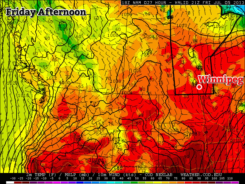
We’ll see a beautiful second half to the week as an upper ridge continues to dominate the Eastern Prairies bringing more heat and humidity to Southern Manitoba with daytime highs climbing to (or just over) 30°C.
Wednesday 31°C
31°C /
19°CMainly sunny.
Thursday30°C /
18°CMainly Sunny. Becoming humid.
Friday 30°C
30°C /
18°CMix of sun and clouds. Humid. Risk of showers or thunderstorms.
The next couple days will bring mainly sunny skies with highs just over 30°C. Winds will remain fairly light and comfortable dew points will make for perfect summer weather. By Thursday afternoon, dew points will begin to climb ahead of an approaching trough line making things start to feel a little sticky.
On Friday, we’ll see continued hot weather however the upper ridge will have moved off and we’ll see a trough line pushing across Southern Manitoba. Depending on how things develop on Thursday night in Saskatchewan, we may see a few dying showers or thundershowers on Friday morning, but the main threat for any storm activity should hold off until the afternoon. Moisture pooling along the trough will push the dew points towards 20°C, making it feel very humid and closer to 37 or 38°C than the high of 30°C. There’s a decent chance we’ll see some thunderstorms on Friday afternoon develop along the trough line, a few of which may be able to become severe. MLCAPE values from 800–1000J/kg are fairly low, however SBCAPE values look to sit between 1500–2000J/kg; if a storm is able to get organized enough to really tap the surface moisture the main threats would likely be heavy rain given the ample moisture available coupled with fairly weak bulk shear and slow storm motion. We’ll have a more comprehensive look at the severe weather threat for Friday in the next blog post. Enjoy that summer weather!
A Look at 2013 So Far
We’ve made it half-way through 2013! This year has started in sharp contrast to last year where unprecedented heat swept over North America very early in the year, leading to a record-breaking start to spring and summer that fast-tracked 2012 to one of the top–5 hottest years ever for Winnipeg. 2013 has seen a painfully slow start to the summer weather as the icy grip of winter hung on for an inordinately long time leading to one of the latest snow melt dates ever record in the Red River Valley.

Monthly average temperatures from the Winnipeg Richardson International Airport for 2013. The dashed line represents the 1981–2010 average.
Looking at monthly average temperatures, perhaps most interesting is how “normal” this year actually has been. January and February ended up almost perfectly seasonal, as have May and June. March and April, however, clearly show the impact of the prolonged cold and snow pack. April finished with a monthly average temperature of –2.1°C which was 6.6°C below normal and a whopping 7.9°C below 2012.
|
Jan |
Feb |
Mar |
Apr |
May |
Jun |
| 2012 |
–10.8 |
–9.8 |
2.2 |
5.8 |
12.2 |
17.7 |
| 2013 |
–16.7 |
–14.0 |
–8.0 |
–2.1 |
11.1 |
17.5 |
| Average |
–16.4 |
–13.5 |
–5.8 |
4.5 |
11.4 |
16.9 |
Table of average monthly temperatures from the Winnipeg Richardson International Airport for 2013. Temperatures are in °C. Average is for the period 1981-2010.
Looking at the year-to-date average temperature, things look about as we would expect. We started off near-seasonal with things falling a little below-normal through our cold spell in the spring which has been maintained as we’ve seen temperatures climbing back to seasonal with no above-seasonal weather. We’re a good deal cooler so far than last year, but that’s expected given the start we had in 2012.

Year-to-date average temperatures from the Winnipeg Richardson International Airport for 2013. The dashed line represents the 1981–2010 average.
Despite the spring that would never end, this year is shaping up to be surprisingly seasonal! The 30°C weather recently is certainly helping me forget the snow that stuck around for so long…
|
Jan |
Feb |
Mar |
Apr |
May |
Jun |
| 2012 |
–10.8 |
–10.3 |
–6.1 |
–3.2 |
–0.1 |
2.9 |
| 2013 |
–16.7 |
–15.3 |
–12.9 |
–10.2 |
–5.9 |
–2.0 |
| Average |
–16.4 |
–14.9 |
–11.9 |
–7.8 |
–4.0 |
–0.5 |
Table of year-to-date average temperatures from the Winnipeg Richardson International Airport for 2013. Temperatures are in °C. Average is for the period 1981-2010.
Precipitation so far this year at the airport has been near-normal and slightly less than last year. I’d just like to make a comment that this spring/summer, especially over the past month, has been extremely wet of portions of the Red River Valley. This season has had an abnormally high number of slow-moving thunderstorms that has locally produced huge amounts of rainfall. Even here in Winnipeg, once some stations from other areas of the city are included, amounts of precipitation so far this year has varied by almost 8 inches!

Table of year-to-date precipitation from the Winnipeg Richardson International Airport & Rob’s Obs unofficial observing site in Charleswood for 2013. Average is for the period 1981–2010.
The observations from Rob’s Obs include two significant precipitation events that only part of the city saw: the first is a back building thunderstorm that brought over 75mm of rain to the southwest portion of the city as well as multiple showers that passed over western portions of the city last week that gave another 20mm of rain to that area. As can easily be seen, while the airport is sitting at near-normal amounts of precipitation, some areas of the city are approaching twice the normal yearly amount. For some other areas in Manitoba, such as areas near Reston, MB, they’ve already received an entire year’s worth of rain over the past month, and that’s on top of the precipitation that’s fallen earlier this year. It’s been very wet in general over Southern Manitoba so far this year. Here’s the year-to-date precipitation values:
|
Jan |
Feb |
Mar |
Apr |
May |
Jun |
| 2012 |
12.0 |
16.5 |
63.0 |
102.0 |
200.0 |
262.0 |
| 2013 |
30.0 |
38.0 |
57.0 |
90.5 |
159.5 |
222.3 |
2013
Rob’s Obs |
3.0 |
8.6 |
24.8 |
66.9 |
185.6 |
441.6 |
| Average |
19.1 |
33.6 |
59.0 |
89.1 |
149.0 |
237.8 |
Year-to-date precipitaiton from the Winnipeg Richardson International Airport & a Charleswood observation site for 2013. Precipitation amounts are in mm. The dashed line represents the 1981-2010 average.
It will be interesting to see how the remainder of the year plays out. While 2012 started off very warm, we actually had below-normal temperatures in the second half of the year that brought us closer to seasonal – although it was still an exceptionally warm year – than it originally seemed that we would. We’ve had a cold start to the year, but we seem to finally be getting into the swing of summer and plenty of hot weather seems to be in the future as long-range models continue to support/sustain a large ridge over the Rockies.