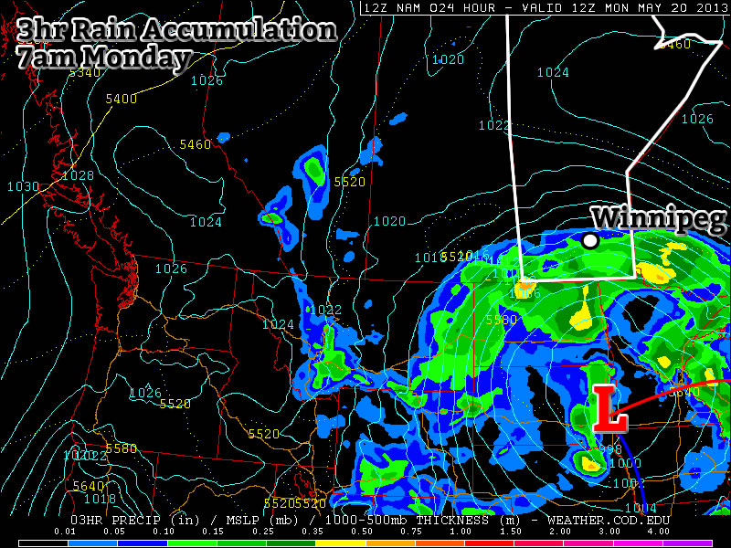
Warm but Unsettled

This week will be warm, but somewhat unsettled. A fairly potent weather system will bring rain and possibly thunderstorms to Southern Manitoba on Tuesday.

image

A low pressure system will bring unsettled weather to Southern Manitoba on Tuesday

Monday

Monday
image
Showers in the morning, then becoming Mainly Sunny.
27°C / 13°C

Monday looks to be the nicest day of the week as we potentially experience our warmest day of the year so far. However, before that happens there may be some shower activity this morning along an approaching warm front. Once this front passes skies will clear and temperatures will begin to rise. High temperatures are expected to be in the mid or upper twenties, with skies becoming mainly sunny by the afternoon.

Tuesday

Tuesday
image
Mainly cloudy. Periods of Rain.
20°C / 6°C

Tuesday will be a rather unsettled day in Southern Manitoba. A strong low pressure system will bring rain and perhaps a few non-severe thunderstorms to the southern-most part of the province. The Red River Valley will be in the warm sector of this system in the morning, allowing temperatures to climb up to around the 20C mark before a cold front goes through later in the morning/early in the afternoon. There is a chance we may see some rain or a weak thunderstorm in the morning, but generally speaking the main area of precipitation is expected to pass to our north in the interlake area. Up north of Winnipeg heavy rain will be possible as a stream of moisture is lifted by this system and forms an area of rain. There may be some embedded thunderstorms within the larger area of rain, but they will not be very strong. The Red River Valley may see some wrap around rain on Tuesday night as the area of precipitation over the interlake slumps south. Precipitation amounts from this system will be nearly impossible to predict due to the potential for embedded thunderstorms. In Winnipeg we should see somewhere in the range of 5-10mm, unless a storm goes through in which case we’ll get more. North of Winnipeg upwards of 25mm is possible, but more precise estimates are too difficult to attempt.

Wednesday

Wednesday
image
Mix of Sun and Cloud
20°C / 7°C

Wednesday will see a return to more settled conditions as Tuesday’s system departs. Temperatures will be around the twenty degree mark with a breezy west wind.

Long Range

The rest of the week looks fairly seasonal temperature-wise, with perhaps a chance of light rain on Thursday and/or Friday. A first glance at the long weekend forecast reveals a chance of rain and near seasonal temperatures…but based on past experience, rain on May long weekend is usually a strong possibility…though I probably didn’t need to tell you that!

Elsewhere in Weather News: May 11th, 2013

Cyclone Duo in Indian Ocean

Two separate cyclones formed in the Indian Ocean this week and will continue to intensify and organize over the weekend. A low shear environment combined with warm sea surface temperatures of around 30°C, were key factors in the formation of these two cyclones.
The first cyclone, located south of the equator, is named Jamala. This cyclone is headed west and is only expected to intensify to a category one hurricane for a short amount of time before weakening to a tropical storm again. Despite reaching category one and heading west towards land, Jamala is not expected to affect Madagascar or any parts of eastern Africa as models show it weakening to almost nothing before reaching the coast.

The second cyclone, cyclone 01B located north of the equator, is more of a concern to Bangladesh and surrounding countries. This cyclone has the potential to cause substantial damage to Bangladesh as land is prone to flooding there. Storm surge will likely be an issue, depending on the strength of the hurricane when it makes landfall. As of Friday evening, 01B had estimated maximum surface winds near the 95km/h mark but was expected to increase in strength as it moved north, towards Bangladesh. Landfall is still a ways away, but its stronger outer bands are expected to arrive near the Myanmar and Bangladesh shores early Tuesday.

Cyclone 01B

Enhanced infrared image of tropical cyclone 01B Friday night. (Source: CIMSS/NHC)

The Indian Ocean cyclone season is most active from the beginning of spring to early winter but it is possible to have cyclones form throughout the year.

Cold Snap This Weekend

Arctic air will continue to slump southwards behind yet another cold front moves through the Red River Valley today. We’ll see temperatures well below normal this weekend, but things should begin to rapidly warm up for the start of next week.

Friday

13°C / -1°C
Mix of sun and cloud. Chance of showers midday.
Saturday

7°C / -3°C
Cool and mainly sunny.
Sunday

12°C / 5°C
Sunny

We’ll see the busiest weather day today as a low pressure system and associated cold front sweeps through the Red River Valley, ushering in cooler Arctic air with breezy northerly winds.

12hr. QPF valid Friday evening.

Total precipitation through the day today.

An area of rain will push through the Interlake with this system while further south, just a few scattered showers will survive along the cold front as it passes through the Red River Valley. Here in Winnipeg, there’s a slight chance we’ll see a shower, but the better chance is further south and east of us, where a little additional daytime heating may help some showers develop with the frontal passage. Areas in the western half of the Red River Valley will likely see little or no rainfall today.

Winds will remain breezy through the day, with southerly winds of around 20km/h shifting to north-westerly behind the cold front and picking up to about 30km/h with gusts close to 50km/h. These north-westerly winds will usher in another shot of Arctic air giving the Red River Valley (hopefully just) one last cold snap through the weekend. Temperatures will climb to around 13°C before the cold front limits our warming and drop just below freezing tonight as winds diminish.

Saturday will bring very cool weather as Arctic air continues to infiltrate southwards. We’ll see a high of only around 7°C under mainly sunny skies and northwesterly winds of 20–30km/h, some 10+°C below normal. Temperatures will drop below zero on Saturday night as well, probably close to –3 or –4°C.

Sunday will see the warm air beginning to build back in, but we’ll only get to around 12°C under sunny skies. Overnight lows should be close to 10°C warmer than Saturday night, though, which will be welcome.

Into Next Week

Looking into next week, it seems like we’ll return to seasonal to above seasonal temperatures. The NAEFS correctly forecasted our cool down and seems to be indicating we’ll be trending upwards over the next 8–14 days. At this point it looks like we’ll return to the low-to-mid 20’s on Monday with potentially warmer weather on Tuesday.

It’s also looking like Tuesday night may bring Southern Manitoba’s first risk for nocturnal thunderstorms of the year. It’s still fairly early, but models are indicating that a low pressure system tracking through the region may develop & sustain an MCS on Tuesday night. We’ll definitely keep an eye on that system! Enjoy the sunshine this weekend and try not to forget that summer looks to arrive (for a more prolonged period, this time) next week!

Arctic Assault on Winnipeg

While we had a glimpse of how absolutely wonderful it will be for summer to be here over the past few days as temperatures shot up into the mid-20’s, the spring-that-never-ends is making an ugly return as multiple shots of Arctic air invade the Southern Prairies.

Arctic air invading the Southern Prairies

Cold Arctic air blasting south over the Prairies. Image from the NAM valid at lunchtime today.

Temperatures through the remainder of the week are going to go from below-normal to more-below-normal as the above pictured cold front continues to slump southwards. The cooler weather was ushered in overnight as the cold front passed through Winnipeg bringing strong, gusty northerly winds. Temperatures today will only climb to around 13°C with strong northerly winds gusting as high as 60km/h. Temperatures will dip down close to the freezing mark under clear skies tonight with widespread low temperatures of around 2°C.

Wednesday

13°C / 2°C
Clearing & windy from the north.
Thursday

15°C / 5°C
Mainly sunny.
Friday

12°C / 0°C
Cloudy with chance of late-morning showers. Clearing in the afternoon.

The rest of the week won’t fare much better. Temperatures will try to climb a little closer to normal tomorrow with highs reaching around 15°C. The low tomorrow night will be a little milder at around 5°C as some warmer air is pushed over the province ahead of an intense low pressure system working it’s way out of Alberta through Saskatchewan.

Friday will be fairly cloudy as yet another cold front sweeps through the Red River Valley. There may be a few showers along the cold front as it pushes through in the late morning and early afternoon, but only a couple mm of rain would be likely to fall, if any. Northerly winds in behind the cold front will clear the skies but limit our high as colder air is ushered in yet again. Overnight lows will drop close to 0°C on Friday night under clear skies.

Long-Term

A cold weekend is ahead of us as we move even deeper into the Arctic air mass. Saturday will be the coldest day with daytime highs only in the mid-to-high single digits with another night with temperatures at or just below 0°C. Conditions will improve on Sunday as the coldest air moves off to our east and the daytime high rebounds into the mid-teens.

At this point, it’s looking like we’ll be in for a huge turnaround early next week. Very warm air is expected to flood across the Prairies as an upper ridge begins building in. At this point it looks like we will start off next week with daytime highs rocketing back up into the mid-20’s. At this point it looks like 24 or 25°C is entirely possible with a slight chance we’ll see temperatures climb into the upper 20’s. The large-scale pattern shift looks like we’ll be moving into a more stable warm pattern, so just make it through the next 5 days and we’ll be enjoying summer!