Pleasant End to the Week

A pleasant second half to the week is on the way with near-normal temperatures and lots of sunshine. Daytime highs will sit near 22°C through the rest of the week with overnight lows around 10 or 11°C. Winds will remain light through today and tomorrow then start to pick up to 20–30km/h out of the south by Friday afternoon. Not a whole lot to say other than it will be quite pleasant!

Wednesday

21°C / 10°C
Mainly sunny.
Thursday

22°C / 11°C
Sunny
Friday

22°C / 11°C
Mainly sunny.

The Weekend

Looking ahead to the weekend, it’s looking more and more likely it will be showery with with a risk of thunderstorms. An upper low is forecast to track across Southern Manitoba on Saturday supporting two lows: one that will track through the Interlake region tied closely to the upper low and a second low pressure system that will track through North Dakota tied to the associated frontal wave[1].

Lifted Index for Saturday Afternoon from the GFS

Lifted Index for Saturday Afternoon from the GFS.

At this point, strong instability is forecast through the Northern Plains of the United States with LI values (shown above) near –10°C showing some fairly significant instability. CAPE values south of the border are also forecast to climb into the 2500–3000J/kg range.

Further north, instability is forecast to be sitting over Southern Manitoba, although the weaker LIs of only of only around –2°C mean that we’ll need stronger forcing to get any significant storms going; with the frontal wave in the US I’m inclined to say that we’ll see more cloudy/showery weather than the potential for any significant storms. Rainfall amounts shouldn’t really come close to the last two systems, although convection in the United States is expected to feed moisture northwards into the upper low and it will spread it out into a band of showery rain again. As the system passes through, more showers are expected on the back side on Sunday.

That’s all still a long ways out, though. We’ll keep an eye out and be sure to give more details by week’s end.


  1. The frontal wave of a system is it’s associated warm & cold fronts.  ↩
A Cool But Dry Start to the Week

Below-seasonal temperatures will persist through the beginning of this week but that gloomy news will be offset by the fact that we should see plenty of sunshine over the next couple days. A disturbance tracking through the Dakotas will bring a chance of showers for the Red River Valley on Wednesday as it pushes the coldest air out of the Red River Valley and pushes us back towards seasonal temperatures.

Monday
image
19°C / 6°C
Sunny. Increasing cloud overnight.
Tuesday
image
18°C / 7°C
Mainly cloudy. Chance of showers near the U.S. border.
Wednesday
image
16°C / 7°C
Clearing in the afternoon. Channce of showers near U.S. border.

Monday

We’ll see nothing but sun today as a ridge of high pressure dominates the weather over the Red River Valley. Daytime highs will sit near 18 or 19°C. We’ll have another cool evening tonight with lows dipping to around 5°C.

Tuesday & Wednesday

Cloud will begin to push in on Tuesday as a low pressure system begins to work it’s way into North Dakota. The chance for precipitation in Winnipeg is very minimal, but closer to the international border it’s more likely that a shower or two will be seen. A sharp cutoff is expected from accumulating rain to nothing, and while the models have been trending towards keeping all the rain on the US side of the border, it’s important to note that around 10mm of rain is forecast for areas only 75–100km south of the Canadian border.

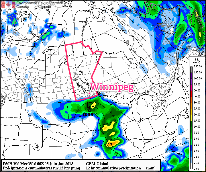
GDPS Precipitation for Tuesday.

Rainfall expected through the day on Tuesday. A sharp cutoff is expected from the accumulating rainfalls in North Dakota and little-to-no rainfall in Southern Manitoba.

While just a few spits of rain is most likely for soaked communities in the southern Red River Valley, we’ll definitely be keeping our eyes on it. If the system ends up just a bit further north than forecast, areas such as Treherne, Morden, Gretna, Altona, Letellier & Emerson could see some light rain. For now, though, I’m expecting just a chance for a shower or two.

Rest of the Week

Heading through the rest of the week it looks like we’ll see couple of mainly sunny days on Thursday & Friday with temperatures climbing back to seasonal[1]. The weekend is worth keeping an eye on as another strong upper low is forecast to move into the region bringing showers and the potential for a few thunderstorms.


  1. The normal daytime high for Winnipeg at this time of year is around 22°C.  ↩

Elsewhere in Weather News: June 1st, 2013

This past week featured a number of severe weather events across the Great Plains of the United States. At least 98 tornadoes had been reported since Monday as of Friday evening.

image

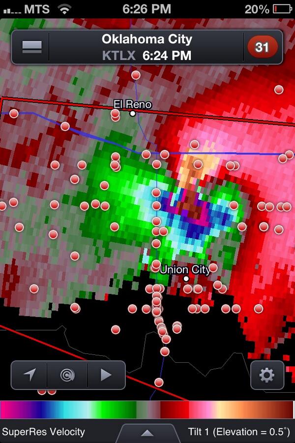
Extreme Rotation was Observed as a Supercell Thunderstorm Approached Oklahoma City on Friday

This series of days with severe thunderstorms and tornadoes was caused by similar atmospheric conditions to what was in place around the time of the Moore, OK tornado. These conditions revolve around four properties that forecasters look for when assessing the potential for thunderstorms, the properties being moisture, instability, shear, and a triggering mechanism. Over the past week copious amount of moisture were present over the US Plains, noted by very humid conditions at the surface. These hot and muggy conditions caused the lower atmosphere to become very unstable generating very high levels of instability. A large dip in the jet stream, called a longwave trough, came onshore from the Pacific Ocean earlier this week putting the plains under a strong jet stream causing wind shear. And finally a series of fronts and drylines offered triggering mechanisms for storms throughout the week. These four ingredients came together perfectly to generate many severe and indeed tornadic storms all over the United States.

The week was capped (no pun intended) off on Friday by a complex of supercell thunderstorms that passed through Oklahoma City causing widespread damage and at least 5 deaths. The rotation in these thunderstorms (seen as the bright colour in the image above) has been referred to by many meteorologists as the strongest they have ever seen. In addition to several tornados touching down in the Oklahoma City Metro area, hail as large as softballs pelted down in some areas while nearly the entire OKC metro area received between 6 – 10” of rain causing widespread flooding with water as deep as 4’ in some places. Flash flood warnings continue this morning for much of eastern Oklahoma state with widespread overland flooding ongoing.

One More Rainy Day; Sunny Weekend Ahead

Rain will stick around for another day with rain blossoming over Southern Manitoba today then persisting through the night as wrap-around precipitation pushes out of the Interlake and through the Red River Valley & the Whiteshell.

Friday

13°C / 6°C
Periods of rain. 20-30mm.
Saturday

15°C / 6°C
Showers ending in the morning then clearing.
Sunday

15°C / 4°C
Mainly Sunny.

Friday

We’ll see rain through most of the day today for a variety of different reasons as the day progresses, but overall rain, at times heavy, will begin this morning and then persist through much of the day. By the evening hours we’ll be moving into the wrap-around precipitation associated with this system which will give us some steadier, but lighter, rain through the overnight period. Accompanying the rain will be strong north-easterly winds, as high as 50–60km/h with gusts as high as 75km/h. All in all, it will be a pretty miserable day with a high of only 12°C. We’ll drop to a low of around 6°C overnight and will likely see between 20–30mm of additional rainfall by Saturday morning.

Saturday & Sunday

A few showers lingering around on Saturday morning will taper off as the system pulls of into Northern Ontario, leaving us with clearing skies through midday into the afternoon. We’ll end the day with sunny skies and a high near 15°C with light winds. Saturday night will be a cool night with clear skies and a low of 4°C. Sunday will be mainly sunny with temperatures a carbon copy of Saturday.

Next Week

At this point, it’s looking like we’ll actually see a chance to dry out. It looks like there will be a slight chance of some showers mid-week over the southern portions of the SW MB & the Red River Valley, but amounts would only be around the 2–5mm mark. All in all, it’s looking quite dry through the next 7 days.