Cold Snap This Weekend

Arctic air will continue to slump southwards behind yet another cold front moves through the Red River Valley today. We’ll see temperatures well below normal this weekend, but things should begin to rapidly warm up for the start of next week.

Friday

13°C / -1°C
Mix of sun and cloud. Chance of showers midday.
Saturday

7°C / -3°C
Cool and mainly sunny.
Sunday

12°C / 5°C
Sunny

We’ll see the busiest weather day today as a low pressure system and associated cold front sweeps through the Red River Valley, ushering in cooler Arctic air with breezy northerly winds.

12hr. QPF valid Friday evening.

Total precipitation through the day today.

An area of rain will push through the Interlake with this system while further south, just a few scattered showers will survive along the cold front as it passes through the Red River Valley. Here in Winnipeg, there’s a slight chance we’ll see a shower, but the better chance is further south and east of us, where a little additional daytime heating may help some showers develop with the frontal passage. Areas in the western half of the Red River Valley will likely see little or no rainfall today.

Winds will remain breezy through the day, with southerly winds of around 20km/h shifting to north-westerly behind the cold front and picking up to about 30km/h with gusts close to 50km/h. These north-westerly winds will usher in another shot of Arctic air giving the Red River Valley (hopefully just) one last cold snap through the weekend. Temperatures will climb to around 13°C before the cold front limits our warming and drop just below freezing tonight as winds diminish.

Saturday will bring very cool weather as Arctic air continues to infiltrate southwards. We’ll see a high of only around 7°C under mainly sunny skies and northwesterly winds of 20–30km/h, some 10+°C below normal. Temperatures will drop below zero on Saturday night as well, probably close to –3 or –4°C.

Sunday will see the warm air beginning to build back in, but we’ll only get to around 12°C under sunny skies. Overnight lows should be close to 10°C warmer than Saturday night, though, which will be welcome.

Into Next Week

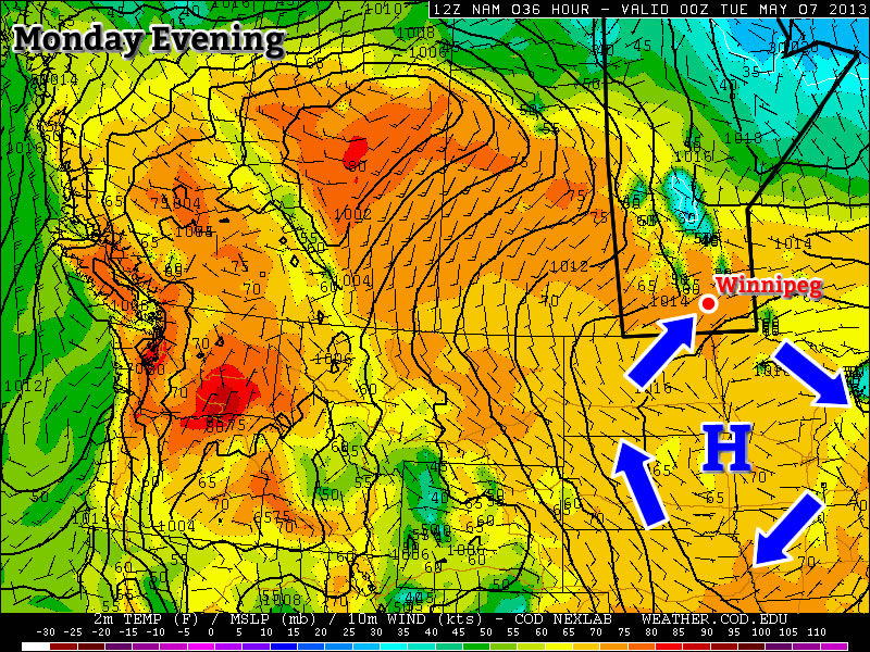
Looking into next week, it seems like we’ll return to seasonal to above seasonal temperatures. The NAEFS correctly forecasted our cool down and seems to be indicating we’ll be trending upwards over the next 8–14 days. At this point it looks like we’ll return to the low-to-mid 20’s on Monday with potentially warmer weather on Tuesday.

It’s also looking like Tuesday night may bring Southern Manitoba’s first risk for nocturnal thunderstorms of the year. It’s still fairly early, but models are indicating that a low pressure system tracking through the region may develop & sustain an MCS on Tuesday night. We’ll definitely keep an eye on that system! Enjoy the sunshine this weekend and try not to forget that summer looks to arrive (for a more prolonged period, this time) next week!

Arctic Assault on Winnipeg

While we had a glimpse of how absolutely wonderful it will be for summer to be here over the past few days as temperatures shot up into the mid-20’s, the spring-that-never-ends is making an ugly return as multiple shots of Arctic air invade the Southern Prairies.

Arctic air invading the Southern Prairies

Cold Arctic air blasting south over the Prairies. Image from the NAM valid at lunchtime today.

Temperatures through the remainder of the week are going to go from below-normal to more-below-normal as the above pictured cold front continues to slump southwards. The cooler weather was ushered in overnight as the cold front passed through Winnipeg bringing strong, gusty northerly winds. Temperatures today will only climb to around 13°C with strong northerly winds gusting as high as 60km/h. Temperatures will dip down close to the freezing mark under clear skies tonight with widespread low temperatures of around 2°C.

Wednesday

13°C / 2°C
Clearing & windy from the north.
Thursday

15°C / 5°C
Mainly sunny.
Friday

12°C / 0°C
Cloudy with chance of late-morning showers. Clearing in the afternoon.

The rest of the week won’t fare much better. Temperatures will try to climb a little closer to normal tomorrow with highs reaching around 15°C. The low tomorrow night will be a little milder at around 5°C as some warmer air is pushed over the province ahead of an intense low pressure system working it’s way out of Alberta through Saskatchewan.

Friday will be fairly cloudy as yet another cold front sweeps through the Red River Valley. There may be a few showers along the cold front as it pushes through in the late morning and early afternoon, but only a couple mm of rain would be likely to fall, if any. Northerly winds in behind the cold front will clear the skies but limit our high as colder air is ushered in yet again. Overnight lows will drop close to 0°C on Friday night under clear skies.

Long-Term

A cold weekend is ahead of us as we move even deeper into the Arctic air mass. Saturday will be the coldest day with daytime highs only in the mid-to-high single digits with another night with temperatures at or just below 0°C. Conditions will improve on Sunday as the coldest air moves off to our east and the daytime high rebounds into the mid-teens.

At this point, it’s looking like we’ll be in for a huge turnaround early next week. Very warm air is expected to flood across the Prairies as an upper ridge begins building in. At this point it looks like we will start off next week with daytime highs rocketing back up into the mid-20’s. At this point it looks like 24 or 25°C is entirely possible with a slight chance we’ll see temperatures climb into the upper 20’s. The large-scale pattern shift looks like we’ll be moving into a more stable warm pattern, so just make it through the next 5 days and we’ll be enjoying summer!

Warmest Weather of the Year so Far on Tap

This week will start out with the warmest weather we’ve seen so far this year.

image

A surface high will bring a mild southwesterly flow to Southern Manitoba on Monday and Tuesday

Monday and Tuesday

Monday
image
Mainly Sunny
22°C / 7°C
Tuesday
image
Mainly Sunny
23°C / 5°C

Monday and Tuesday will be two very nice and very similar days. Both days will feature high temperatures in the low to mid twenties in Southern Manitoba with sunny skies. The wind will be from the south-west on both days and may become a bit breezy in the late morning and afternoon hours. Other than that there isn’t much negative to say about the start of the week…except that our first twenty degree weather of the year won’t fall on a weekend!

Wednesday

Wednesday
image
Mainly cloudy. Chance of showers.
12°C / 3°C

A cold front will move through Southern Manitoba on Tuesday night, setting up cooler conditions for Wednesday. This will be a fairly strong front, but the lack of moisture ahead of it will mean little if any rainfall is expected as it passes. Temperatures on Wednesday are expected to be in the low teens with a strong north wind.

Long Range

The rest of this week looks to remain on the cooler side, with temperatures remaining in the teens on Thursday and Friday. By Friday conditions may rebound back close to seasonal values, but unfortunately models show an arctic high pressure system dropping south into our area just in time for next weekend.

Elsewhere in Weather News: May 4th, 2013

Let it Snow!

Record-setting snowstorms were the topic of conversation in parts of the US this week.

Snowfall reports

Snowfall map until Thursday morning. (Source: NOAA)

Springtime weather was delayed once again as a significant trough moved across Central US dragging down unseasonably cold arctic air with it. Friday morning, temperatures at 850mb reached below freezing all the way down to Mexico; and snow fell from Northern Ontario all the way down to northern parts of Arkansas and Oklahoma! Many snowfall records were shattered, some of the most significant being:

  • Britt, Iowa – Achieved a snow depth of 28cm, beating the old record of 25cm (in 1947).
  • Chippewa-Falls/Eau Claire, Wisconsin – Recorded a snowfall of 22cm shattering the old record of 5cm (in 1946).
  • Extreme north-west Wisconsin – Recorded a snowfall of 46cm.

The trough will not make it to the East Coast as the main jet stream is retreating north and a cutoff low will form in southern US. This cutoff low is expected to slowly drift across the region feeding into tropical moisture while dropping significant rainfall over parts of the south-east and east-central US. Accumulations of over 80mm are expected, increasing concerns that flash floods might be a problem over the weekend.

In other news, a category one cyclone formed off the north-eastern coast of Australia, however it had minimal impacts on land as it fizzled out and only brought lowland flooding and erosion to coastal areas.

Italy also saw an active week with a large tornado reported in it’s northern region. An approaching shortwave combined with significant instability and sufficient shear on Friday was the cause for severe storms in the area.

Short video of the Italian tornado as seen from the nearby city of Castelfranco Emilia. (Source: R. Melotti)