At the risk of sounding like a broken record, more of the same is ahead for the rest of the week with daytime highs near 0°C.
Wednesday Mainly sunny. -2°C / -12°C
Thursday A mix of sun and cloud 0°C / -7°C
Friday Mainly sunny. 1°C / -5°C
We’ll see temperatures climb a degree or two each day through the rest of the week as the sun continues to slowly chip away at the cooler air over the province. The normal daytime high for this time of year is around 3–4°C, so we’ll still remain a little below normal over the next few days. We’ll see some cloud move in tonight, which should help keep the overnight lows from dropping too much. Skies will clear out on Thursday with sunny skies being dominant through the rest of the week. Overnight lows should actually end up moderating a bit as some warmer air pushes in aloft.
This benign weather pattern looks to continue for at least another 7–10 days with no significant weather systems expected to move through Southern Manitoba. This slowly warming, dry weather is good news in light of the most recent flood forecast which has been upgraded to a risk of moderate to major flooding in the Red River Valley.
We’ll slowly warm up this week, but no spectacular weather is in store.
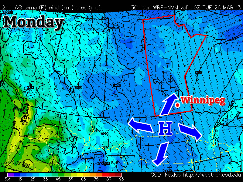
Surface temperatures and pressures on Monday (College of Dupage – NAM model)
Monday through Wednesday
Monday Clearing -3°C / -14°C
Tuesday Mainly sunny -4°C / -14°C
Wednesday Mainly sunny -3°C / -12°C
Monday will be another carbon-copy of what we’ve seen a lot of lately. Temperatures will be in the mid minus single digits in most areas, with the exception of forested areas and areas within the cities, where temperatures will be a good five or so degrees warmer than that. There will be a chance of flurries during the morning into the early afternoon before we clear out by later in the day. Tuesday will again be almost identical to Monday – except sunnier – so no further elaboration is needed about that.
Wednesday should see temperatures come up a bit more, with highs in the low to mid minus single digits in most areas. Like Monday and Tuesday, forested and city areas will be a bit warmer than the open prairie, with values around or just above freezing.
Long Range
The long range is neither good nor bad. It looks like we should warm up even more later this week, with more widespread freezing or above freezing temperatures expected. However, further out in the long range models show more cold air dropping south into Southern Manitoba around next weekend, with no more substantial warm-ups currently in the forecast.
Tornadic activity was experienced across the globe this past week, affecting countries from Bangladesh to Australia and even China.
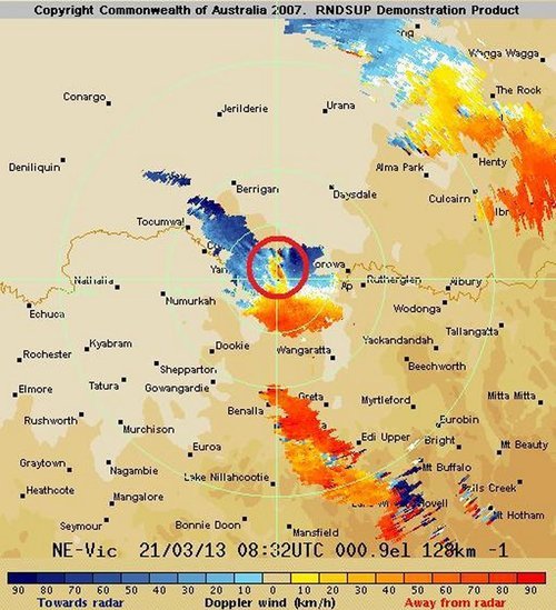
Capture of the Doppler Radar velocity at the time of the tornado (area of dark blue vs. red). (Source: BoM/ @vicstormchasers)
In Australia on March 21st , at least two powerful tornadoes touched down on the border of Victoria and New South Wales, ripping through more than a half-dozen towns lying along the Murray River. The strongest twister, with an estimated F2 rating on the Fujita scale, caused major damage to the towns it swept through – tearing roofs off their structures, throwing cars around and snapping power lines. In total, 20 people were injured and two had to be airlifted to hospital. Thankfully no deaths were associated with this tornado outbreak. A deep low pressure system responsible for spawning these tornadoes lay just off Tasmanian coast with a cold front stretching up into Australia.
Video of the Australian tornado dangerously close up. Power flashes and debris can clearly be seen flying through the air. (Source: Daniel Clarke)
The tornado that touched down in Bangladesh on Friday, March 22nd also caused a fair amount of damage to a few rural eastern Bangladesh towns. The twister was on the ground for about 15 minutes but it is not yet known what the strength of the tornado was estimated to be. At least 100 injuries and 20 deaths were reported as a result of this tornado.
The people of Bangladesh are more susceptible to injury and death from tornadoes since finding a safe haven from them is not as easy as heading down to a basement to take cover. Most houses in the area are built out of mud and don’t have a sturdy structure, making it difficult to escape when residents find themselves in the path of a twister. Tornadoes are common in Bangladesh from March to late April before they transition into the monsoon season.
Guangdong, a southern province of China, was also in the crosshairs of severe weather this week. A supercell produced egg size hail accompanied with a tornado that made its way through the city of Dongguan (pop. 400,000). Significant damage occurred – many buildings collapsed and the storm even overturned a ferry offshore. These Chinese storms were the deadliest storms of the week, accounting for 24 deaths and over 200 injuries.
Hail the size of eggs covers the ground in Dongguan, China. (Souce: I.B. Times)
We’ll continue to chip away at the cold air and push towards seasonal temperatures over the next few days as the ridge of high pressure anchored over the province slowly weakens.
We’ll see mainly sunny skies today as temperatures climb from anywhere to -7°C on the northwest side of the city to closer to about -3°C downtown. Some cloud will start pushing into the Red River Valley from the east tonight which will limit our overnight low to only around -14°C instead of dropping back into the -20’s again. Saturday will see more cloud than sun with temperatures climbing to around -3°C and dropping to slightly below -10°C Saturday night. The clouds will start to break up on Sunday; we’ll likely see more sun than cloud through the late morning and afternoon period as the temperature climbs up to around -4°C yet again.
Long Range
Current indications for the next week or so are that not much will change; no large systems are in our forecast which will certainly be a help to the flooding situation. Days just below zero combined with the strong March sun and no additional precipitation are excellent for helping with the potential flood situation by melting the existing snowpack at a gradual pace.