Major Winter Storm to Start the Week

A major winter storm will impact all of Southern Manitoba to start the week. Accumulations will be very heavy in some areas, but luckily this won’t be another blizzard.

image

Weather Conditions at 12pm on Monday (GEM-Regional)

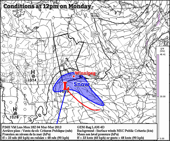
A developing low pressure system currently located in south-western Saskatchewan will be responsible for the snow. This system was formed as a powerful upper-level disturbance moved onshore in British Columbia late last night. This disturbance continues to track across the Prairies and will provide the lift necessary to generate the snow.

The snow has already begun to fall in south-western Manitoba this evening. Bands of moderate to heavy snow have been falling just south-west of Brandon. Heavy snow will continue to develop in this region as the evening progresses. Further east in the Red River Valley snow will begin to fall gradually this evening, with heavier bands moving in overnight. By Monday morning all of Southern Manitoba will be in the snow. It is expected that the heaviest snow will fall mainly south and west of Winnipeg, particularly along the international border, though the city will see decent accumulations as well. The following graphic shows our snowfall forecast for Southern Manitoba:

image

Snowfall totals by Tuesday morning across Southern Manitoba.

The wind through this event won’t be particularly strong, with speeds of 20-30km/h gusting to 40-50km/h expected during the day on Monday. This will cause some blowing and drifting snow on the highways, but within urban areas the wind won’t be a significant factor. Temperatures through the day on Monday will be fairly steady in the mid to upper minus single digits, so the wind chill won’t be very high either. The snow will taper off on Tuesday night, with only lingering flurries expected by daybreak on Tuesday.

Tuesday will see our weather begin to settle down as the storm departs. As mentioned above, we may see a few flurries during the day on Tuesday, but additional accumulations will be small. Temperatures won’t drop off much, with highs once again in the mid to upper single digits.

Wednesday will again be a rather unexciting day weather-wise. Temperatures will be in the mid to upper minus single digits with a brisk south-easterly wind.

Elsewhere in Weather News: March 2nd, 2013

Strong Cyclone Affects Australia, Temperature Records Tallied

This past week a cyclone, Rusty, formed off the coast of north-western Australia and quickly spun into a strong cyclone by Australian standards. The cyclone made landfall as category one by Saffir Simpson Scale standards, (rated category 3 by Australian Bureau of Meterology) and even though it brought hurricane force winds, it affected an area of Australia that is sparsely populated. This meant that not much damage was caused by Rusty and only some overland flooding was reported as well as about a hundred houses without power. As Rusty moved inland, heavy rains and high wind gusts were the main concerns; over 450mm of rain fell and gusts of 150km/h were experienced around and south of the area where Rusty made landfall. Rusty’s quick strengthening off the north-western was aided by unusually warm waters – near 31°C and only about ten knots of shear present at the time.

Rusty Flooding

Flooding in an area just south of where Rusty made landfall. (Source: @Sturap)

This week the Australian Bureau of Meteorology also announced that the warmest summer on record (records since 1910) occurred this past summer. Australia’s average temperature surpassed the normal by 1.1°C and 95% of the country had above average temperatures this summer. Birdsville, Australia which typically has an average high temperature between 35°C and 38°C during summer had 31 consecutive days above 40°C. It has truly been an impressive summer 2012-2013 temperature-wise for Australia!

Average temperature anomalies

Average temperature anomalies for Australia summer 2012-2013. Much of Australia above average. (Souce: BoM)

In other news, another significant blizzard went through the Southern US Plains bringing more short-term drought relief to the area. Some areas in north-western Oklahoma and the Texas Panhandle received over 35cm of snow. Blizzard conditions were in place as strong winds and heavy snow fell along the deformation zone of the low pressure system. Almost all roads in the Texas Panhandle were impassable because of large snow drifts, residents were urged to stay home. Weather in the Southern Plains will be fairly calm this weekend and at the start of next week; no significant precipitation accumulation is expected.

Seasonal Weather Continues Through Weekend

Our streak of surprisingly seasonal weather will continue through the weekend as another push of Pacific air sweeps across the Southern Prairies.

850mb Temperatures Saturday Morning

850mb temperatures valid on Saturday morning. A warm front will be pushing across Southern Manitoba ushering in mild Pacific air and a very slight chance of a dusting of snow.
Friday

Mainly sunny.
-7°C / -14°C

We’ll see a mainly sunny day today as spend a final day under the effects of a weak ridge. Temperatures will climb to around –7°C, although depending where you are in Winnipeg, temperatures could climb locally to –5 or –4°C as more and more concrete is exposed.[1] Temperatures will dip down tonight to around –15°C before clouds begin to move in ahead of the approaching warm front.

Saturday and Sunday

Saturday

Mainly cloudy.
-3°C / -7°C
Saturday

Mainly cloudy.
-2°C / -7°C

Milder Pacific air will push into the Red River Valley this weekend warming temperatures up close to the 0°C mark. Both Saturday and Sunday will be mainly cloudy and other than a very slight chance on Saturday morning of a light dusting, no snow is expected. Temperatures will only drop to around –7 or –8°C both Saturday and Sunday night.

Next Week

Models seem to indicate a system diving southwards into North Dakota but differ on what to expect from it. Current indications are that no significant snowfall will be seen over Southern Manitoba, although the GEM-GLB is painting a swath of 20+cm through our region. We’ll keep a close eye on it as the weekend progresses. Even with the passage of this system, temperatures aren’t expected to drop more than a few degrees and we should continue to see daytime highs warmer than –10°C through the week.


  1. Concrete has a lower albedo than snow-covered ground. Albedo is a measure of reflectivity of a surface; because concrete’s albedo is lower, it reflects less sunlight and warms up more. This effect is very noticeable at this time of year over forested areas where temperatures can climb as much as 10°C higher than open, snow-covered areas adjacent to them.  ↩

Pleasant Weather Continues

The beautiful weather we’ve been having this week will continue in a slightly cooler fashion through the rest of the week as the benign weather pattern holds on.

500mb Winds valid 18Z Thursday

500mb heights and wind speeds valid at 18Z on Thursday. A slack flow will continue over Southern Manitoba through the rest of the week.
Wednesday

Mainly cloudy.
-3°C / -11°C

Today will be the least pleasant day of the bunch as a passing “cool” front moves through the Red River Valley. Winds will pick up this morning to 30km/h out of the north as we climb to a high of around –3°C. With mainly cloudy skies expected through the day today, it will feel a little cool out there. No snow is expected, but one certainly can’t rule out a few flakes, especially near the western escarpment of the RRV and over SW Manitoba. The clouds will begin to break up overnight as we drop to around –11°C.

Thursday and Friday

Thursday

Mix of sun and cloud.
-6°C / -15°C
Friday

Mainly sunny.
-6°C / -16°C

Thursday will see a mixed sky as a weak ridge of high pressure sits across Southern Manitoba. As we move into Friday this ridge will be able to slowly erode most of the cloud over the Red River Valley, although SW Manitoba will likely remain relatively cloudy over this same time. Other than Friday being sunnier, Thursday & Friday look to be near carbon-copies of each other with daytime highs near –6°C and overnight lows dipping to around –15°C. Winds should remain fairly light to the end of the work week.

It’s worth mentioning that with the sun beginning to get stronger, even at temperatures around –5°C the sun will be able to work at melting the snow. With a weak ridge over us and light winds, it’s fairly likely that some fog patches will develop through the Red River Valley during the nights. At this time, it doesn’t seem like they should be too extensive, but it’s certainly possible that they could be quite dense. Over the past few nights, fog has formed just south of the U.S. border and reduced visibilities to as low as 200–300m. Any fog that does form should burn off fairly quickly by mid-morning.