Mild and Settled

This week will start out mild, with little in the way of active weather.
image

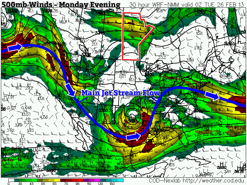
NAM model predicted 500mb winds showing a slack flow through Southern Manitoba

A relatively stagnant flow will prevail over Manitoba for much of this week as the main storm track remains well to our south. This will give us seasonably mild temperatures and little if any precipitation.

Monday
image
Mainly sunny
-2°C / -16°C
Tuesday
image
Mainly sunny. Chance of flurries overnight.
-1°C / -8°C
Wednesday
image
Mainly cloudy. Chance of flurries.
-4°C / -18°C

Monday and Tuesday

Monday will be a pleasant day, with temperatures in the low minus single digits in most areas. There may be a few readings up near the zero degree mark in localized patches. There will be a light to moderate south wind through the day, but it won’t be particularly noticeable in most urbanized areas.

Tuesday will be almost identical to Monday, with temperatures once again generally around or just below zero. There may be patches of fog in Southern Manitoba again on Tuesday morning, but they will dissipate with daytime heating in the morning. The south wind from Monday will die off for the most part, making it a non-factor. A passing weather system may bring us some light snow on Tuesday night into Wednesday, but accumulations will be small.

Wednesday

As that system passes by on Wednesday morning, a weak cold front will go through, dropping temperatures slightly. This won’t prompt any kind of significant cool-down, but it will switch the wind to a slightly brisker northerly flow. Temperatures won’t change much however, with high temperatures in the low to mid minus single digits.

Long Range

In the longer range there is little to talk about. It appears we’ll cool down a bit towards week’s end, but otherwise models show no real trends over the next 7-10 days. No significant warm-ups are in the forecast, nor are there are major weather systems in the forecast. Unfortunately, this also means there is still no sign of spring…but at least there’s no sign of a nasty winter pattern returning either.
Elsewhere in Weather News: February 23rd, 2013

Major Snowstorm Hits US Plains

Another trough digging through the southern half of the US this past week, caused trouble for travellers and residents of the Great Plains. Moist air from the Gulf of Mexico made its way north into Kansas which fell as freezing rain and snow ahead of the warm front. In the warm sector a line of thunderstorms, some severe, formed along the trough line that plowed through part of Texas and Louisiana.

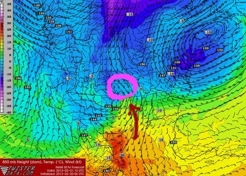
850mb analysis

850mb analysis of early Wednesday morning. Heavy snow was already falling at this time. Highest accumulations circled in pink. (Source: Twisterdata)

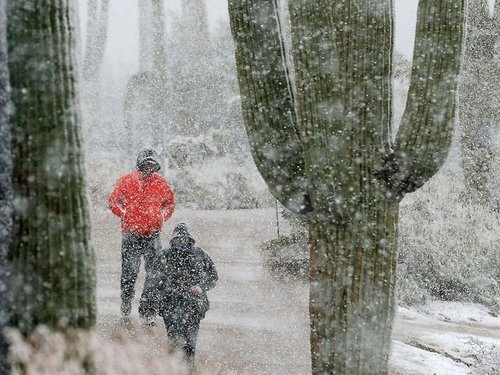
Highway conditions quickly deteriorated after snow started falling and 150km of I-70 had to be shut down in Kansas due to many vehicle accidents. This system also prompted the closure of schools, delayed flights at airports or even closed airports such as the Kansas City airport. This same trough is to be blamed for suspending play at the PGA in Marana, Arizona where an uncommon sight could be seen; snow – about 4cm of it, covered luscious greens with cacti nearby in the background.

Snow affecting PGA

PGA golfers leaving the course while it’s snowing. (Source: AP)

Snowfall rates of 3-5cm/h were not uncommon for several hours in Kansas and Nebraska and contributed to significant snow accumulations. Highest accumulations were just below the two foot mark (60cm) in south-central Kansas with a good part of Kansas receiving over 20cm of snowfall. Most of the Southern Plains residents welcome any type of precipitation at this time however due to a severe/extreme drought is currently in place through much of the Plains (as talked about in last week’s EIWN). Last Thursday’s storm should at least make for slight improvements in the short term drought index but for longer range improvements the Plains need to get out of a persisting dry pattern.

Recent model runs show another major snowstorm, with as much as another foot of snow, Sunday night into Monday for the US Plains.

Beautiful Weekend Ahead

It’ll be a great weekend to get out and enjoy outdoor activities as we see little in the way of weather and seasonal temperatures.

Friday

Mix of sun and cloud.
-7°C / -14°C
Saturday

Mainly sunny.
-7°C / -14°C
Sunday

Becoming cloudy, chance of patchy flurries.
-6°C / -10°C

There isn’t much to say about the next few days; today and tomorrow will be pleasant with clouds slowly clearing out and daytime highs near –7°C. Overnight lows will sit around –14°C for the next couple nights. There will be increasing cloudiness as a warm front approaches on Sunday bringing with it a slight chance of some patchy flurries and a high temperature around –6°C. The overnight low on Sunday will only be –10°C as warmer air moves in.

Next week looks to be off to a very pleasant start with above-normal daytime highs of about –5°C and no significant weather expected through the first half of the week. Long-range models hint that we may cool down back to seasonal or just below seasonal temperatures for the second half of the week.

Have a great weekend and get out there and enjoy the nice weather!

A Return To Seasonal Weather

After a surprisingly cold day yesterday, we’ll be quickly returning to seasonal temperatures over the next couple days with little weather to worry about.

12hr. QPF valid Thursday at 18Z

12 hour precipitation accumulation from the RDPS model valid near lunch time on Thursday. The RDPS is forecasting roughly 1–3cm of snow over Western Manitoba as a cold trough lingers over the area.
Wednesday

Increasing cloud.
-17°C / -20°C

Some cloud will push in today as another disturbance begins to push into the region but our highs will still remain below normal, sitting at about –17°C for most of the Red River Valley. Winds will remain fairly light out of the south through the day. Temperatures will drop only a few degrees tonight to about –20°C thanks to lingering cloud cover.

Thursday

Thursday

Becoming cloudy.
-10°C / -15°C

We’ll see a return to normal temperatures Thursday as warmer air continues to work it’s way into Manitoba. Highs will sit near –10°C under a mix of sun and clouds. The cloud will be from a system to our west which is not expected to impact the Red River Valley but will bring some light snow to southwestern Manitoba. Skies will remain fairly cloudy overnight as we drop to –15°C.

Friday

Friday

Mix of sun and cloud.
-9°C / -13°C

Friday will once again bring a mix of sun and cloud. Almost a carbon copy of the day before, our daytime high should get up to around –9°C. Temperatures will drop to only about –13°C on Friday night as we head into a pleasant weekend with seasonal temperatures of around –8°C expected and little chance of snow.

Enjoy the return to seasonal temperatures and get out there and enjoy Festival du Voyageur or go for a skate down on the river! If you didn’t see it yesterday, be sure to check out our special post yesterday summarizing the Louis Riel Day blizzard.