Bitter Cold Continues

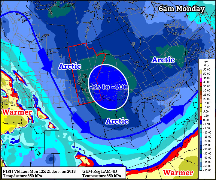
The bitter cold entrenched over Southern Manitoba will persist a few more days as another Arctic Ridge slides through the province.

850mb Temperatures valid Wednesday Morning

850mb temperatures valid this morning from the GEM-REG. A pool of bitterly cold Arctic air over the province will restrict daytime highs to the mid-minus-twenties today.

We’ll see an extremely cold day today with plenty of sunshine and a high only around –25°C. This is some 12–13°C below our normal daytime high for this time of year of –12°C. Temperatures will drop below –30°C tonight for a 3rd night in a row.

Light Snow on Thursday

Temperatures will continue to be cold on Thursday with a high near –21°C as a weak disturbance slides across the province in the northwesterly flow aloft. This will spread an area of snow across southwestern portions of the province early in the morning and into the Red River Valley near midday. With temperatures so low SLR values will likely be quite high, somewhere in the range of 20:1 to 25:1. This very high “fluffy factor” will help produce snowfall accumulations of 2–4cm by Thursday evening. Temperatures will climb to around –20°C on Thursday, aided by the cloud cover that will push in.

On Friday sunshine will return as we face another cold day with highs below –20°C. Fortunately, it appears that warmer air will finally be pushing into the region by Friday night. Temperatures look to drop only a few degrees from our daytime high as we then see much warmer weather on Saturday and Sunday as highs climb back towards the –12 or –13°C mark. It looks like we’ll see a mix of sun and cloud through the weekend, with a chance for another couple of cm of snow on Sunday.

An Arctic Blast

This week will feature the coldest weather so far this winter, which is probably about all you need to know.

850mb temperatures on Monday morning

As we come off Monday morning’s very cold low temperatures, daytime highs won’t be able to get very warm, with values in the mid minus twenties expected. When you factor in the wind chill it will feel more like the low minus forties on Monday morning and the mid minus thirties on Monday afternoon. As we move into Monday night temperatures are expected to plummet once again. Models have had significant difficulties figuring out what will happen by Tuesday morning. Models have shown lows as cold as -47C on Tuesday morning (obviously an erroneous value), or as warm as -28C. It seems probable that we’ll end up somewhere between those two extremes, with lows in the mid minus thirties most likely. It shouldn’t be very windy at all on Tuesday morning, so at least we won’t have a big wind chill to contend with as well. It looks like we’ll “warm” up a bit on Tuesday, with daytime highs in the low minus twenties expected.

We shouldn’t see extreme overnight lows again on Wednesday morning since a weak passing weather system will prevent temperatures from bottoming out. However, another arctic front is forecast to pass through Southern Manitoba during the day on Wednesday, setting up more very cold weather for late week.

Unfortunately, there are no indications to suggest that we’ll see a warm-up any time soon. That means we may be stuck with cold to very cold weather for the rest of January.

Elsewhere in Weather News: January 20th, 2013

Intense Heat Wave Continues in Australia

A significant heat wave has remained in place for most of Australia’s southern half, this past week. The large ridge of high pressure has kept about 70-80% of Australia under extreme high temperatures (over 40°C) and in turn has created dangerous conditions in which bushfires can occur. Total burn bans were in place for a few communities in the southern half of Australia and firefighters are on high alert. As of Friday there were 142 bushfires burning in New South Wales alone and 29 of them were 0% contained.

Temperature map

Map of Australia’s extreme temperatures on January 12th, 2013. (Source: Australia’s BOM)

Residents of Tasmania have been experiencing similar weather conditions this New Year, contributing to a massive brushfire that had been raging through a large area of its south-eastern peninsula two weeks ago. Here, 1,000 people had to be rescued by boat from their homes. The damage in that area has not yet been tallied, but at least 20 houses, including a school, has burned down to the ground and at least one person is confirmed dead.

On Friday, January 4th, the village of Wudinna, located on Australia’s southern coast, reached extreme temperatures of 48.2°C, and various other cities broke their daily temperature records as well. Adelaide recorded all-time January high temperatures on the same day as the mercury rose to 44.1°C. Even more impressively, on January 12th Moomba (South Australia) managed to reach a temperature of 49.6°C – Australia’s hottest temperature in 15 years. The average temperature for Southern Australia ranges between 25°C and 35°C in January, and a little cooler for areas along the coast. This past week, Australia’s Bureau of Meteorology even had to go to the extreme by changing the temperature scale on their maps because temperatures constantly exceeded the scale during this intense heat wave.

Trough

Potential through coming through which would help cool down the temperatures late next week. Also to note a possible tropical disturbance on Australia’s north side. (Source: Australia’s BOM)

Although it is not uncommon to see heat waves affecting specific areas of Australia, to see between 70 and 80% of Australia experiencing a significant heat wave such as this one, is not a common sight. Significant heat will persist into next week before a large trough moves into the region and brings an end to the sweltering heat by next Friday. Interestingly enough, models are also showing a tropical cyclone forming off the Australia’s North Coast around the same time that the heat is predicted to come to an end.

A Little Snow Before The Coldest Weather This Winter

Two batches of snow followed by the coolest temperatures of the winter are in store for Southern Manitoba over the next few days.

Clipper Snowfall Totals

Forecast snowfall totals from this clipper system across Southern Manitoba.

An Alberta Clipper will begin it’s march across the Prairies today, rapidly moving from Northern Alberta east-southeast into Northern Minnesota by tonight. This system will drag a warm front eastwards across Southern Manitoba, spreading 1–2cm of light snow across the Red River Valley. The snow will ease off this afternoon to just scattered light flurries as the weak leading impulse moves off into NW Ontario.

Temperatures will warm to around –8°C by this afternoon, with the warmer daytime highs near 0°C locked into the extreme SW portion of the province. A second shot of snow will push into the Red River Valley tonight as the main low centre of the Alberta Clipper moves through the region. Temperatures in the RRV will rise to –4 or –5°C by midnight before starting to drop as the cold front moves through. The bulk of the snow will start near midnight and taper off on Saturday morning with a further 3–5cm of snow accumulation for a total of 4–7cm by the time this whole system moves through.

A few flurries will be around on Saturday as Arctic air begins building into Southern Manitoba yet again. Fairly strong northerly winds gusting up to 60–70km/h will develop early Saturday morning which will result in significant blowing snow in the RRV outside the City of Winnipeg. “Ground blizzard” conditions will be relatively widespread, with particularly poor visibilities as low as 100–200m on west-east running roads, such as the Trans-Canada Highway from Winnipeg to Portage La Prairie. Given the already slick conditions of many roads around the province, be sure to give yourself plenty of extra time if you need to travel on Saturday. The winds will lighten up by mid-afternoon, marking the start of our entry into a major deep freeze. Bitterly cold Arctic air will be pushing southwards behind this clipper system, with temperatures falling to around –25°C by the end of the day. Temperatures will plummet tomorrow night, with overnight lows through the Red River Valley dropping to the –30 to –35°C range. Temperatures will rebound slightly on Sunday as a weak disturbance brings some cloud and a chance of a flurry or two, but even colder air looks to be pushing in on Sunday night.

If the models are to be believed (which I do have some hesitation at the moment), temperatures will drop through the day on Monday to nearly –30°C by the end of the day, with overnight lows dipping to nearly –40°C. I think that the models are getting a little too excited about how cold it will get. The GEM-GLB model’s overnight lows have been 5–6°C too cold over the past week, so it’s more likely that we’ll see lows closer to –35°C than –40°C. At that point, though, it’s colds enough that those numbers don’t even matter. It’s certainly going to be an extremely cold start to next week.