A Break From Winter

This week will feature a much needed break from winter, as temperatures soar to well above seasonal values.

Surface Temperatures

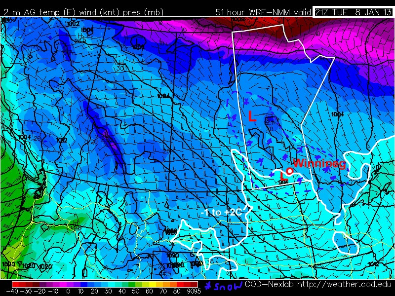
Temperatures on Monday will reach the mid minus single digits in Southern Manitoba. There will be a fairly stiff west wind in place throughout the day though, which will make conditions considerably less comfortable than they would otherwise be. On Tuesday we’ll have our first shot at the 0C mark this week, as a low pressure system brings in a warm surge of air from the west. Unfortunately there may be some snow on Tuesday associated with the low pressure system. Amounts will not be particularly high, probably no more than a few centimetres in most areas. Despite the small amounts there could be travel difficulties as the snow is likely to be wet in nature and could present icing issues.

On Wednesday temperatures will remain warm, with highs just slightly below the freezing mark in most areas. We’ll have our best shot at getting above zero on Thursday as a big push of warm air moves into Manitoba from the south-west.

At this point it appears that this warm spell will end on Friday, with a low pressure system passing to our south prompting another arctic air mass to descend into Southern Manitoba. This system may bring a decent snowfall to portions of Southern Manitoba on Friday as well, though it is too early to discuss the details of it. In the longer range most indications suggest that we are in a for a very cold period through the middle of January, with a significant arctic air mass settling over the Prairies. With that in mind, there is all the more reason to enjoy this week’s pleasant “break” from winter.

A Break from the Deep Freeze

After enduring a cold end to December, Southern Manitoba is in store for a break from the deep freeze as milder Pacific air works it’s way across the Prairies.

850mb temperatures on Thursday afternoon

850mb temperatures from the GEM-REG model valid on Thursday afternoon. The yellow shaded area denotes warmer (above 0°C) air flooding eastwards across the Praries aloft.

As the low pressure system that brought us light snow overnight slides off into Minnesota, it will drag cooler air into Southern Manitoba behind it. Through the Red River Valley, temperatures will fall to around -13 or -14°C today as colder air from the North slumps southwards. Tonight will see temperatures drop to around -20°C with some cloudy periods and a chance of a light flurry or two.

Milder air will make it’s way into the Red River Valley tomorrow as southwesterly winds pick up to around 30km/h in the morning and begin to scour out the remaining Arctic air. Temperatures will climb up to about -5°C by the evening, marking the start of a stretch of above-normal temperatures. For early January, our normal daytime high in Winnipeg is about -13°C; over the next week, we’ll remain slightly above normal with daytime highs near -9°C punctuated by a day or two where the daytime high climbs back towards the 0°C mark. We’ll likely see plenty of sun over the next week, too, a result of the drier Pacific flow, which will help make the weather quite pleasant.

If you’re wondering where our 2012 Winnipeg temperature summary is, don’t fret! We’ve just been a little busier than expected and are working hard to get it up in the next couple days! Until then, get out there and enjoy the break from the deep freeze.

Elsewhere in Weather News: December 23rd, 2012

From Snow to Tornadoes in the US this Week

This past week a large trough of low pressure swung through the eastern half of the United States bringing a wide range of weather; from blizzards in the Midwest, to tornadoes in the South-East and even dust storms in Texas.

The tornado, confirmed by the National Weather Station, occurred in the early morning hours on Thursday and cut a path of destruction through Mobile, Alabama. Preliminary reports indicate that the tornado was of EF-1 strength (between 138km/h and 178km/h winds) and had a path spanning 11 kilometers. It tore down roofs, uprooted oak trees and cut power off to about 10,000 residents. Most of the power was restored by Friday but the cleanup will certainly still be underway this weekend.

Blizzards, spanning from Nebraska to Michigan, accompanied this potent trough of low pressure and thundersnow was even experienced at times. Over 600 flights out of Chicago were cancelled and officials had to close various interstates across the Midwest, simply because it was too dangerous to travel. Here are a few of the higher snowfall amounts recorded as of Friday:

  • Gaylord, MI: 50cm
  • Madison, WI: 34cm
  • Des Moines, IA: 32cm

On Wednesday, near Amarillo, Texas, as the front came through it was accompanied with very strong winds (gusting to 80km/h) which managed to stir up a large dust storm. This dust storm was caused in part by the severe winds but also the severe drought currently occurring in the Southern Plains, including Amarillo, where the dirt is loose and can easily be picked up. The dust storm went through Interstate 27 producing near zero visibility and triggered a 23 vehicle pile-up.
By Saturday the trough will have moved off to Atlantic Canada, much of the US Midwest and Plains will experience below-normal temperatures as arctic air floods in from the Canadian Prairies.

Drought

Significant drought throughout the US Plains, both long-term and short-term. (Source: Drought Monitor, NDMC)

We again wish you happy holidays and all the best in the New Year!

Clouds To Start Breaking Up

The overcast weather will begin to break this weekend as a system tracking through the central Prairies brings drier air eastwards across the Prairies. Temperatures will cool off with the clearing skies, but the sun will be a welcome sight that may make many not care.

Snow in Assiniboine Park

A snowy, overcast scene at Assiniboine Park, courtesy “Mentally Guitarded.”

Clouds will stick around for today with continued periods of light snow as temperatures continue to remain in the optimal snow-generating range. Winds will be light out of the south as we reside on the back-side of a ridge which passed through overnight and temperatures will climb to around -11°C. As a low pressure system tracks across the Prairies tomorrow, higher-level cloud will begin to stream over Southern Manitoba. This mid-cloud will help produce scattered snow showers in areas that have been socked in with low cloud for a while, but also begin to dissipate that persistent low cloud as well.

On Saturday we’ll likely see a mix of sun and cloud as more mid-level cloud streams over the southern portion of the province. There should be some sunny breaks as well and temperatures will climb once again to around -12°C. Clouds will break up a little overnight as cooler air pushes in from the northwest behind this system and we’ll head to an overnight low closer to -20°C. By Sunday, we should see a little more sun than on Saturday with temperatures climbing only to around -16 or -15°C. No significant snow accumulations are expected through the weekend.

Next week, including Christmas, is looking fairly sunny and cool, with overnight lows near -25°C and daytime highs near -18°C. We’ll be taking a slight vacation over Christmas here at AWM, so have a great holiday and a happy new year!