Warmer Weather and a Bit of Snow on The Way

Arctic ridging will keep our temperatures low over the next couple days but rest assured, warmer weather is on the way.

12hr. QPF for Thurday Night

12hr. precipitation amounts for Thursday night. A band of snow will pass through Southern Manitoba with greatest accumulations through the Interlake region and amounts diminishing towards the U.S. border.

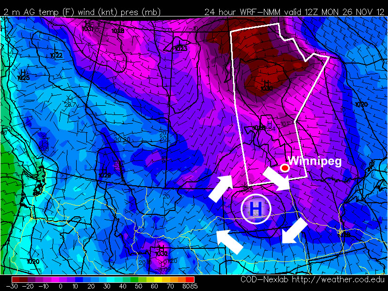
We’ll see another cooler than normal day today as a weak low passing through Central/Eastern Manitoba pulls more cold air southwards and allows re-enforcement of the Arctic ridge in place over the Prairies. We’ll see temperatures climb to about -10°C under a mix of sun and clouds today as breezy winds develop out of the south to 30km/h. This will make it feel a lot closer to -20 out there. There may be a slight chance of a very light flurry over Winnipeg and the Eastern Red River Valley this afternoon, however the chances are slim and if it does happen, there won’t be any significant accumulations.

Temperatures will dip towards the -18 to -20°C mark tonight under partly cloudy skies. Tomorrow we’ll see another day with highs near -10°C with a mix of sun and clouds. A warm front will push through on Thursday night, bringing with it some light snow to the Red River Valley. Lightest accumulations will be in the Southern Red River Valley with greater amounts in the Northern Red River Valley into the Interlake; in general, 2-4cm accumulations are likely. Areas south of Morris may, however, end up with little to no snowfall if the area of snow stays just a little tighter to the system centre as it passes through.

For Friday into the weekend we’ll see an unsettled pattern with bouts of light snow possible through much of the time. We’ll be under cloudy skies, but comparatively balmy temperatures will be in place with daytime highs generally around -1 to -3°C.

Cold Start to the Week

This week will start off feeling a lot more like winter, as temperatures drop well below normal.

A high pressure system will bring cold conditions to Southern Manitoba on Monday

A high pressure system will bring cold conditions to Southern Manitoba on Monday

Temperatures this morning will be more like those you’d expect in late January, not late November. This morning’s cold temperatures will moderate somewhat by afternoon, with highs in the mid minus teens expected – not exactly November weather! Luckily some cloud cloud should move in during the afternoon hours, allowing Monday night to be significantly warmer than Monday morning. In fact temperatures may rise a bit on Monday night, up into the -6 to -10C range, in association with a weak low pressure system passing through. This low will bring a few flurries to Southern Manitoba overnight, with accumulations of no more than a centimetre or two expected. Unfortunately, another high pressure system will build in behind this passing low, bringing colder temperatures again for the daytime hours of Tuesday. Temperatures will begin falling back into the minus teens on Tuesday morning as cooler air spills in from the north-west. Tuesday night will be another cold one, with lows back down around the -20C mark. It looks like another small warm-up is on the way for Wednesday as yet another passing low pressure centre allows temperatures to climb back up into the minus single digits.

There remains some uncertainly in terms of how the late week period will play out. Models generally agree that we will stay below-normal for Thursday and Friday, but exactly how cold is not entirely clear. There have also been hints of a more active storm track setting up through Southern Manitoba from next weekend into the following week, something to watch as this week progresses.

Elsewhere in Weather News: November 24th, 2012

Severe Flooding Strikes England

Intense flooding has hit parts of the UK these past couple of days and more is to come this weekend. A strong low pressure system approaching England from the south-west has brought with it plenty of moisture which has already flooded out 300 properties and caused one death.

Flooding

Roads flooded out quickly in South-West England as torrential rains fell this past week, more is to come. (Source: The Guardian)

South-West England is most at risk. Areas including Exeter and Bristol were included in the ‘amber risk’ (second highest level) which was issued by the Met Office as more localised flooding was likely to occur. By Saturday afternoon, it will not be uncommon to see rainfall reports exceeding 50mm in South-West England. This, coupled with ground already saturated to its maximum, will cause flash flood conditions where streams could easily overflow in a matter of hours. In total, 70 flood warnings and 150 flood alerts had already been put in place as of Friday. High winds add to the storm’s grave concern, as gusts of 90km/h are not out of the question for Saturday’s event.

Surface analysis

Surface analysis of the UK on Saturday at 7pm. (Source: Met Office)

Areas of South-West England typically see an average of 16 rainy days and 70mm of rainfall in November. Therefore it’s not unusual to see rain in that area during the month of November but the expected amount to be seen this weekend is on the high end of the spectrum. The highest 24-hour rainfall ever recorded in South-West England (Martinstown) was in 1955 where 279mm, over half of Winnipeg’s annual precipitation, fell!

A Mixed Bag

We’ll see some sun, some more snow, and temperatures all over the place as we see a wild weather pattern over the next few days.

12hr. QPF for Saturday

Precipitation accumulation for Saturday, showing some snow pushing through Southern Manitoba with greatest accumulations north and east of Winnipeg.

Sunshine will dominate today as a very strong Arctic high slumps through the Prairies. This high pressure system is a result of cold Arctic air pushing southwards behind a cold front that passed through yesterday. This will limit daytime highs today in the Red River Valley to only about -12°C. Temperatures will plummet towards -20°C tomorrow night as the ridge pushes through Southern Manitoba and breaks up remnant cloud left behind.

More cloud will begin pushing in late overnight into Saturday morning as another system tracks through the Northern Prairies. This system will warm things up a bit for us, bringing our daytime high on Saturday to a comparatively balmy temperature climbing just over -5°C. To go with those warmer temperatures will be some light snow with accumulations only around 2cm for much of the Red River Valley, including Winnipeg.

This system moves out on Saturday night, and we’ll move into a slightly more stable pattern. Sunday will likely be a mix of sun and cloud as we deal with a little bit of cloud left behind from Saturday’s system, with a high near -12°C again. As we head into next week, things look fairly steady with overnight lows near -15°C and daytime highs starting in the high minus teens and climbing into the low minus single digits.