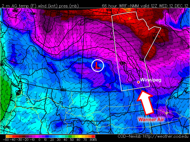
A Return to Winter

Colder air is set to return by the end of the week as a low pressure system ushers in Arctic air as winds shift to the northwest behind it.

GFS Sounding for 06Z Thursday

A sounding for 06Z Thursday (midnight-ish tonight) from the GFS model depicting an above-freezing level.

Before the cold weather returns we’ll have one more pleasant day. Although skies will be cloudy today, we’ll see temperatures once again climbing above 0°C through the Red River Valley with a light southerly flow. Conditions will begin to degrade overnight as a low pressure system pushes into Southern Manitoba.

The first threat with this system will be the potential for freezing rain tonight. As the sounding1 above shows, an AFL (Above Freezing Level) with sub-zero surface temperatures will be in place through much of the overnight period before eroding early Thursday morning. The saving grace for the Red River Valley could be that most of the precipitation looks to push north of the valley through the Interlake. If, however, any precipitation manages to wander through the RRV overnight, then there’s certainly a decent chance it’ll fall as freezing rain. Cooler air begins pushing in at all levels early Thursday as we move to the back side of this system and winds switch to the northwest.

Winds will strengthen out of the northwest on Thursday to 40km/h with gusts towards 60km/h as a band of snow slumps southwards with the cold front. At this point, it looks like snow will push into the Red River Valley mid-morning and last until the early evening (6-8PM). Snowfall accumulations will likely be around 5cm. Temperatures will start near -5°C tomorrow morning and fall to -8 or -9°C by the evening. We’ll head to an overnight low of around -15°C tomorrow night.

Sunny skies should dominate Friday and Saturday with highs near -10°C. A weak disturbance looks to bring a chance of light snow to the Red River Valley again on Sunday.


  1. A “sounding” is a way of plotting how the temperature and dewpoint change with height. The sounding is for a single location and plots the temperature/dewpoint with height in pressure coordinates as the vertical axis. 

Mild Weather Continues

The warm weather from the weekend will continue into this week. High temperatures at or above zero will continue.

850mb temperatures will be around 8C in Southern Manitoba on Tuesday

850mb temperatures will be around 8C in Southern Manitoba on Tuesday

Temperatures will drop off slightly on Monday compared with Sunday as the wind switches to a more westerly direction. High temperatures will be held down a bit as cooler air moves in from the vast expanse of snow covered land to our west. Highs will generally be in the -4 to 0C range over Southern Manitoba, with more widespread above zero temperatures in south-eastern areas. On Tuesday most of Southern Manitoba should get above zero, with the exception of heavily snow covered areas which will hover close to the freezing mark. Warm air just above the surface (seen in the graphic above) will offer the potential for high single digit or even low double-digit temperatures in snow-free areas if it can stay sunny (mainly south-eastern Manitoba). Southern Manitoba should once again remain mainly above freezing on Wednesday as a light south-easterly flow allows warm conditions to continue.

Current forecasts show a low pressure system sliding through Manitoba on Thursday. This system will bring more snow to parts of Manitoba, though it is unclear at this point if Southern Manitoba will see any significant amount of the white stuff. What does appear likely at this point is that colder air will be pulled down as this system passes through. As a result colder conditions are expected on Friday and may last into the weekend. More details on the potential impact of this system will be available in Wednesday’s post.

Enjoy one of the last mild stretches before our real winter sets in!

Elsewhere in Weather News: November 17th, 2012

Wildfire Flare Up in Southern Australia

On Monday the 12th of November, a large wildfire in Southern Australia flared up. Residents had to be evacuated in the region of Tulka as the wildfire threatened houses. Over 100 firefighters battled the blaze but unfortunately they were unsuccessful in their attempt to control it that day. In total, the fire burned nearly 5,000 acres, destroying seven properties. No one was injured, though animals such as koalas that lived in the area where the wildfire took place needed veterinary attention. The fire has been contained since Tuesday.

Wildfire

Picture of the Tulka Wildfire. (Source: Michael Sleep/ABC)

This month, Port Lincoln, a city near Tulka, received only 4.4mm rain in comparison to its 20mm average for the month of November. The lack of precipitation combined with a high of 36.4°C on Sunday November 11th (13°C above the November average) contributed to conditions ripe for wildfires in Southern Australia at this time of the year. Tulka typically receives minimal rainfall in the month of November due to dominant high pressure off the coast of Southern Australia and troughs that sporadically make their way to the region. It is predicted that most of Australia will have a warm and dry summer, having an indirect relation to the weak El Nino that is forecast to develop this winter. If this were the case, it would be an active wildfire season in Australia this summer.

Systems map

Systems map of Australia of next Wednesday, high pressure dominating Southern Australia. (Source: Weatherzone)

Several days prior to this event, a few other wildfires flared up in Western Australia but they were located in a remote area and did not directly affect population.

Wildfire NASA picture

Picture of a wildfire in Western Australia on November 7th, taken by NASA. (Source: NASA)

Mild Weather To Bring Cloudy Skies…Again

A southwest flow aloft is bringing warmer air back to the Prairie provinces, however with plenty of snow around to melt, our sunshine won’t last long…

A shot of sunshine in Winnipeg; a rather elusive feat as of late. The sun will go back into hiding this weekend. Photo credit: Instagram user @shwaahall.

We’ll see mainly sunny skies today as temperatures climb to right around the 0°C mark with winds out of the south at 30km/h. As winds subside this evening after sunset, stratus clouds and fog will begin to develop in the Red River Valley as all the moisture from melting snowpack is stuck underneath the inversion and is forced to condense as the temperatures drop. Expect an overnight low of –5°C tonight. The fog patches will stick around the RRV into Saturday morning before lifting.

Clouds will stick around for the day on Saturday as temperatures climb to about –1°C. Fog patches will likely redevelop on Saturday night as temperatures dip down to –5°C again. Sunday looks to be a mainly cloudy day as well, with a daytime high once again right near the freezing mark.

For now it looks like we may see the cloud get scoured out of the Valley as a surface trough moves through on Monday; for now, enjoy the sunshine today…we likely won’t see it for another couple days.