A significant change in the weather is underway today as Arctic air blasts southwards, pushing out the pleasant, above normal temperatures we’ve had lately and replacing it with cloudy, cool, windy weather. I hope you enjoyed the last few days, because you probably won’t enjoy the next few.

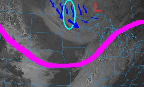
850mb temperatures valid this morning from the GFS model. Warm and cold fronts are depicted.
A cold front, tied to a powerful low pressure system moving through central Manitoba, swept across the Red River Valley overnight, ushering out the warmer temperatures aloft that have given us pleasant temperatures the past few days. In it’s wake is a dramatically different pattern than we’ve seen lately.
Upper troughing will dominate the Prairies as a secondary low, currently spinning up over Montana/Wyoming tracks eastwards and pulls more cold air southwards. This will establish us into a much cooler pattern where cooler, Arctic air is entrenched over the region and it’s significantly harder for us to get those nice warm breaks.
Today we’ll see winds begin to pick up out of the north as temperatures climb to only around 13°C. We’ll get cloudier as the day goes on, and by the late afternoon into the evening some showers will push into the southern regions of the Red River Valley. Further north, we’ll see a chance of showers, however it will be more difficult for any organized precipitation to develop over the northern Red River Valley.
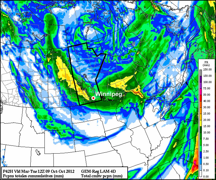
As the aforementioned US low tracks through South Dakota, winds will shift to the north-northeast over the RRV, which when combined with the cooler air being dragged southwards, will bring lake-effect showers into the central Red River Valley. Current model solutions hint that Winnipeg may be in the path of these, however, as usual, the exact wind direction will be crucial in determining where the showers will fall. Temperatures will drop to around +3°C tonight.
Thursday will be a cool day, with northerly winds persisting, cloudy skies and a high of only 7 or 8°C. Lake effect showers will persist in the lee of the lakes, and scattered showers will likely be found throughout the entire Red River Valley. Cold air continues to pour southwards and we’ll drop to near 0°C. Precipitation is…complicated for Thursday night. The GEM-GLB & GFS models are forecasting only around 5mm of rain for Thursday evening over SE Manitoba, including the Steinbach region. Other models, such as the NAM, have a much worse forecast. The NAM spins up the low over the states into a very powerful storm system, which taps into some Gulf moisture over the east-central States and lifts it northwest and slams it into a deformation zone oriented north-south over the Red River Valley. In this outcome, 1-2 inches of precipitation is forecast to fall, some as rain, however much of it as snow. Should we believe the NAM, it would result in many communities east of the Red River waking to find over a foot of snow on the ground! Ensemble forecasts suggest that this is an outlier; most solutions favour a quicker track to the low with less precipitation over the Red River Valley. We’ll keep a close eye on this as it develops, but you should be prepared for the potential for poor travelling conditions on Friday.
Things calm down on Friday as this system leaves the region and we’ll be left with cloudy skies and a high around 10°C. Things look to improve a little bit for the weekend (e.g. we may see the sun), but temperatures will remain locked in the high single digits to low teens as cold, arctic air remains entrenched over the region.