A Weather Moment is proud to continue serving Winnipeggers and the surrounding communities into 2012. As this site continues to develop a community, we plan to bring several additions to the site to help create the go-to place for your weather needs and curiosities this year. Several improvements and additions are already underway, and I thought I’d just outline some of the new things coming up for the site.
More Content
Writing about the weather can be a feast-or-famine affair. Since I started the blog, I find there are stretches where you could write a lengthy post each day about upcoming weather, followed by 2-3 weeks of…well…nothing. However, what’s the point of coming to a site that doesn’t update for 2 weeks? So with that in mind, we plan on providing more regular content. There are several aspects that will help with this:
- The tentative plan is to have a M/W/F posting schedule, with additional posts as needed given various weather setups. Please have patience as over the next month we try to meet that schedule and/or decide on other setups that might work better (e.g Mon/Wed/Sat). We are aiming for 3 posts a week, though.
- When there are stretches of no significant weather, we plan on tapping into the original plan of doing more educational posts on how various aspects of the weather work. I’ve been disappointed that I haven’t really followed through on that promise for the blog, and it will be rectified this year!
- In order to keep up with all this, I’m privileged to announce that Scott, who previously ran, blogged, and forecasted at steinbachweather.ca will be joining staff as an occasional writer. I have full faith in his analysis and forecasting skills and think he will be an excellent addition to the writing team! Some of you are familiar with him, I’m sure, and he is excited to come on board and be a part of this growing community. So people know, I’ve now added a small label at the bottom of each post so you can see who the author of it is.
Expanded Site
The second main goal I have for 2012 is to being to provide tools on this site that will help facilitate forecasting. Over the past year, I’ve developed several exciting new tools that are unlike anything available on the internet right now. I plan on providing them on A Weather Moment to help the community develop their own forecasts and add to discussions. With the tools I aim to provide by the end of February, three things will be much easier:
- Viewing model data
- Viewing satellite & other real data
- Access to text bulletins such as the FOCN45 Prairie Weather Outlook and the SPC’s Day 1/2/3 Severe Weather Outlooks.
As these tools are added to the site, I hope to enable this community to further their understanding of the weather and to have the skills and tools to make informed weather decisions by yourselves!
WX-Central Mobile
As the person who maintains the mobile version of U of M Weather Central, I plan on doing a significant upgrade to make it the best place to get your weather information while on the go. Expect that to be finished sometime in the second half of this year. If you aren’t using it yet, I highly recommend you check it out (and not just because I made it) at http://tinyurl.com/mobilewx.
Lastly, as this site is always a work in progress, always feel free to get in touch with us by e-mailing any questions or suggestions to aweathermoment@shaw.ca.
The Rest
I’m very excited for the future of this site. With Scott’s help, we want to help build a passionate community of enthusiasts and amateur forecasters by providing the topics, forum and tools.
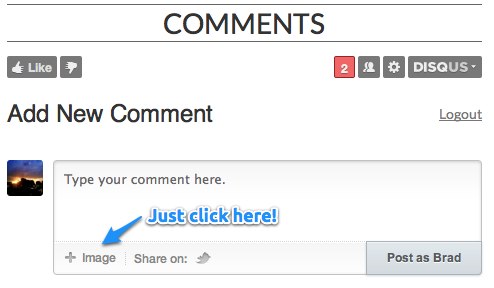
User Photos: One thing I want to strongly encourage people to send in their photos during significant weather events. The two best ways to do it are to either e-mail them to us or attach them to a comment:
The last post about the record-breaking temperatures is the most commented on post since this site began! Thanks all for contributing to the conversation! I hope you stick with us and enjoy the ride this site will be going on this year. Won’t be long before we can talk about thunderstorms again!
Design: I am continuing to update the page’s design, to make it better able to support new features in the future and to make it aesthetically pleasing. I’d love feedback on it as I go, and don’t be surprised if you see a new thing here or there when you’re browsing the site. I’ve also done quite a bit of work on the mobile version of the site, so if you’re using an iPhone or iPod, give it a try! I’d love feedback on how it looks on older iDevices (i.e. iPod Touch 1G/2G/3G, iPhone 3G/3GS) as well, if anybody is using them!
And that’s all the site news for now! Back to the weather…


