Temperatures Set to Soar This Weekend

Winnipeg will see daytime highs climb over 10 °C above seasonal normals this weekend as a surge of Pacific warmth washes over the region.

Winnipeg will see very mild November weather over the next few days. While some of the mild air is in place already, today will be a semi-typical “transition day” for the Red River Valley. Temperatures will climb to around 10 °C in the city today with breezy southerly winds near 30 gusting 50 km/h. Cloud cover should increase today, beginning with partly cloudy skies this morning giving way to mixed to mostly cloudy skies this afternoon.

The southerly winds will ease and shift westerly this evening as a trough moves through the area. Skies should clear out behind it as temperatures dip to a low near +4 °C.

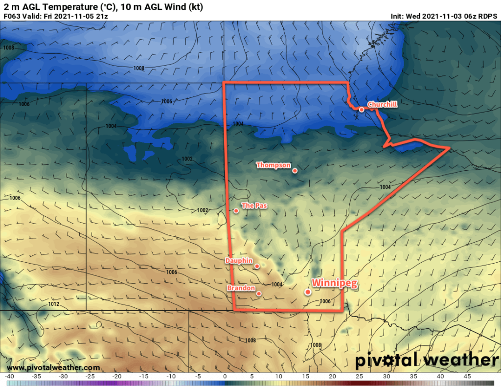
With a westerly flow in place for the weekend, even warmer daytime highs will move into the region. The region will see mainly sunny skies with light west-southwest winds. The high in Winnipeg will reach 13 or 14 °C, making for an absolutely beautiful early November day. Temperatures will fall to a low near +1 °C with partly cloudy skies on Saturday night.

RDPS 2m Temperature Forecast valid 21Z Saturday November 6, 2021
Very mild early November temperatures will spread across the southern Prairies this weekend.

More pleasant weather is on the way Sunday with highs back up into the low teens. Skies should be partly cloudy again with light winds. Lows will dip down again to around +1 °C.

Long Range Outlook

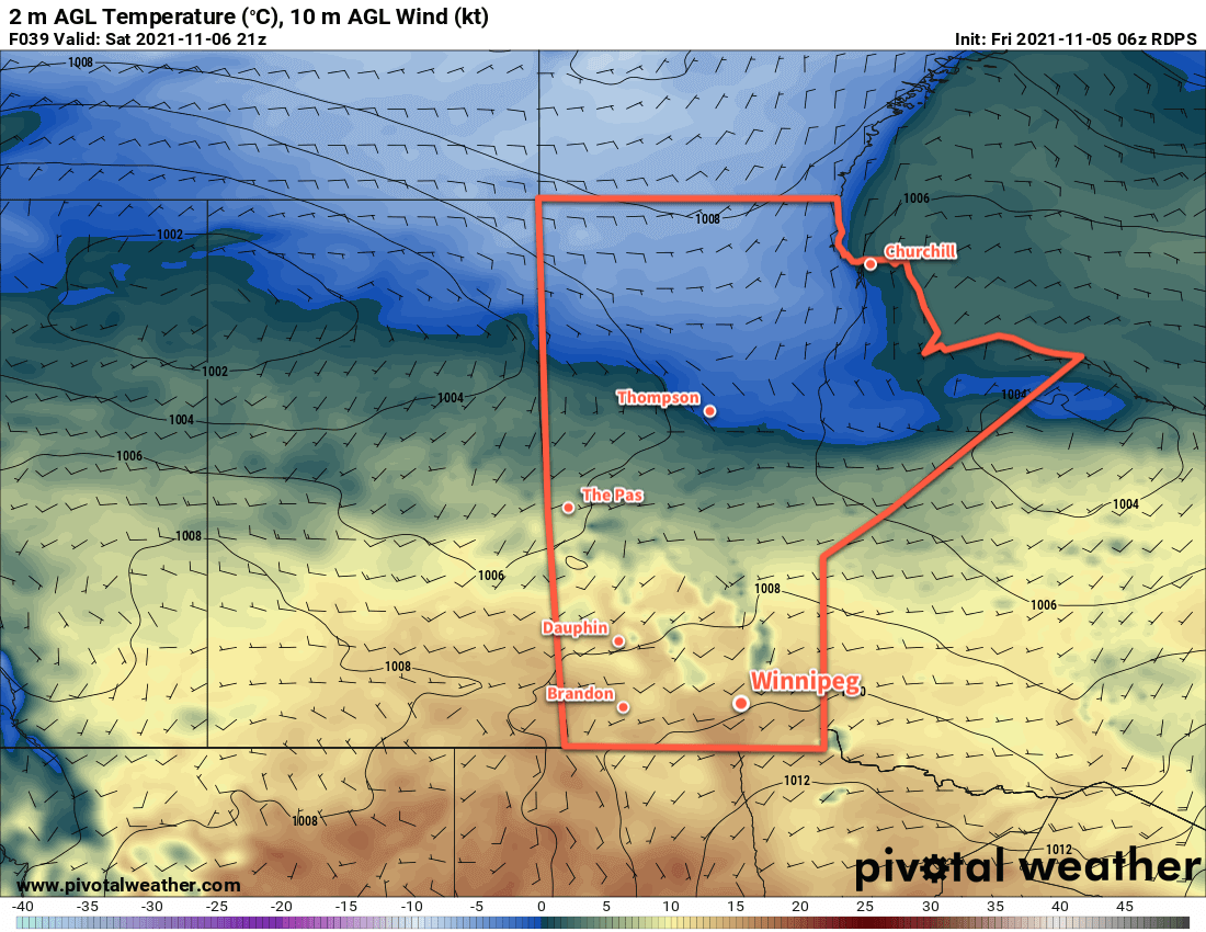
The beautiful weather will continue into the start of next week with highs near 10 °C on Monday and Tuesday. The overall pattern will begin to change mid-week as cooler air starts pushing southwards. Temperatures will slide back towards seasonal values with unsettled conditions through the second half of the week.

Today’s seasonal daytime high in Winnipeg is 2 °C while the seasonal overnight low is -6 °C.

Warming Up in Winnipeg

The weather is going to warm up in Winnipeg this week as an upper ridge builds across the Prairies.

Despite the cold start to the day, today will be a pleasant change from the weather of the past few days in Winnipeg. With the worst of the Arctic ridge to the east, the city will see temperatures climb to a high near 7 °C under sunny skies. Winds won’t be too much of an issue, either, staying light out of the south. Weak ridging will stay over the region tonight which, combined with the light southerly wind, will allow temperatures to fall back to a low near -6 °C.

On Thursday, some warmer air will begin pushing towards Manitoba as an upper ridge builds eastwards. This will bring a few clouds back along with southerly winds of 20–30 km/h. Temperatures will climb to a high near 8 °C in the city. More cloud will push in overnight as a low pressure system begins moving eastwards out of Alberta. With that cloud will come more warm air and southerly winds up to around 30 km/h. This combination of cloud and wind will keep the overnight lows seasonally mild at around +2 °C.

RDPS 2m Temperature Forecast valid 21Z Friday November 5, 2021
Mild Pacific air will sweep across the Prairies over the remainder of the week.

Friday will bring mostly cloudy skies to the region as a low pressure system crosses the province. The southerly winds will gradually weaken through the day as a trough moves into the Red River Valley. Temperatures will be held back a bit by the cloud cover, but the area should still see highs near 9 or 10 °C. There may be a slight chance of rain showers on Friday evening, but much of the precipitation associated with this system should be weakening as the trough advances eastwards. Temperatures will stay mild on Friday night as the trough passes and winds shift westerly. Winnipeg will see a low near +3 °C.

Long Range Outlook

The seasonally warm weather will stick around for the weekend with highs climbing into the low teens. Overnight lows should stay above freezing through the weekend. A change in the weather looks to arrive next Wednesday when a system moving through the Prairies brings several days of unsettled conditions as it sweeps the Arctic front back south across the region. Near-seasonal temperatures should return in the second half of next week.

Today’s seasonal daytime high in Winnipeg is 3 °C while the seasonal overnight low is -6 °C.

Cool Start To The Work Week

November is off to a seasonably cool start as highs in the low single digits send cloud cover streaming off the Manitoba Lakes.

A brisk northwesterly wind will keep temperatures cool and skies cloudier in Winnipeg. The city will see temperatures climb only to around 3 °C today with mixed skies as low cloud streams southwards off the Manitoba Lakes. The lakes are also producing some rain showers/snow flurries, but the winds should keep that activity out of the city. Breezy northwest winds of 30 gusting 50 km/h will pick up late morning and make for a rather chilly afternoon.

The winds will ease this evening as they shift a bit more westerly. This change in direction may end up bringing a few snow flurries into the city from Lake Manitoba overnight. Temperatures will dip to a low near -3 °C with cloudier skies.

RDPS 2m Temperature Forecast valid 12Z Wednesday November 3, 2021
An Arctic high will bring cold temperatures to the southern Prairies on Wednesday morning.

On Tuesday, the wind will continue to shift westerly and ease as an Arctic ridge slumps into the region. This will bring partly cloudy skies to the city with a high around 2 °C. Skies will clear out on Tuesday night, allowing temperatures to plummet to one of the coldest nights of the season. Lows will dip to around -9 °C.

Winnipeg will see sunny skies on Wednesday with temperatures recovering to around +4 °C. It will be a nice day with light winds. Temperatures will dip back down towards -6 °C or so on Wednesday night.

Long Range Outlook

The second half of the week will see a collapse of the upper low sitting over NW Ontario while an upper ridge builds across the Prairies. This will bring a new push of mild Pacific air into the region. Daytime highs will climb back towards the 10 °C mark by the end of the week. Conditions should stay dry until cooler air begins pushing back into the region sometime in the middle of next week.

Today’s seasonal daytime high in Winnipeg is 3 °C while the seasonal overnight low is -6 °C.

Mild Friday Gives Way to Late Fall Chill

Warmer weather will stick around for one more day in Winnipeg before a major pattern change brings seasonal conditions back to the region.

Temperatures will continue to climb well above seasonal averages in Winnipeg today. Under partly cloudy skies, southerly winds up to 30 gusting 50 km/h will push highs up to around 11 °C. A low pressure system tracking across the Prairies will push cloud cover into the region tonight as temperatures dip to a low near 7 °C.

The pattern change begins on Saturday as the aforementioned low crosses the province. Winnipeg will see cloudy skies as winds shift northwesterly through the day. Those winds will strengthen up to 40 gusting 60 km/h in the afternoon. This system will bring a chance of showers to the region, but the bulk of precipitation will fall to the north. Temperatures will hover around the 7 °C mark through the day, then drop quickly in evening as colder air begins filtering southwards into the region. Temperatures will dip to low around the freezing mark with northwest winds of 20–30 km/h.

NAM 24hr. Precipitation Accumulation Forecast valid 00Z Sunday October 31, 2021
A low pressure system will spread rain across potions of southern Manitoba on Saturday.

In the wake of the low, the cool air and northwesterly winds will generate quite a bit of low cloud and precipitation that streams off the Manitoba Lakes. This should keep skies mostly cloudy in Winnipeg on Sunday, and depending on the exact wind directions, the city may end up seeing some snow flurries or rain showers through the day. Temperatures will slowly rebound to a high around 4 °C with breezy northwest winds near 30 gusting 50 km/h.

The winds will finally ease on Sunday night as temperatures dip to a low near -1 °C.

Long Range Outlook

Cloudier conditions will continue through the first half of next week as cool temperatures and northwest winds continue to produce cloud off the Manitoba Lakes. With the air mass over the region continuing to gradually cool, the chance for rain showers or snow flurries will likely continue through the first part of the week.

Conditions will settle for the second half of the week as winds shift westerly, but temperatures will stay near or slightly below seasonal values for the rest of the week.

Today’s seasonal daytime high in Winnipeg is 6 °C while the seasonal overnight low is -4 °C.