Cold Front Brings Return of Seasonal Temperatures

A cold front sweeping across the Prairies will bring seasonal temperatures back to southern Manitoba after one more mild day.

It will be another mild day today in Winnipeg with a high near 21 °C as southerly winds continue to push warmer air north. Those winds will be breezy at around 30 gusting 50 km/h midday into the afternoon. The upper ridging over the region will continue to keep skies mainly sunny.

Things will change tonight, though, as a low crosses the province. A cold front will sweep southeastwards across the region overnight, ushering in a more seasonal air mass. Winnipeg will see the cloud cover increase overnight with temperatures dipping to around 6 °C. Those southerly winds will taper off overnight, then pick up out of the north to 30 km/h by Tuesday morning.

RDPS 2m Temperature Forecast valid 03Z Tuesday October 19, 2021
A cold front will sweep through southern Manitoba on Monday evening.

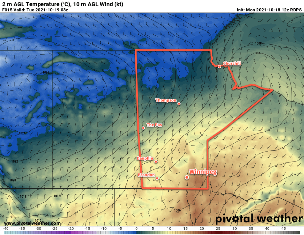
For the rest of the week, a broad area of high pressure will slowly settle into Manitoba. For Tuesday and Wednesday, it will bring northerly winds to the region and send temperatures back to near-seasonal values. It will be quite windy on Tuesday with northerly winds up to 40 gusting 60 km/h, but Wednesday will see those winds ease into the 20–30 km/h range. A cloudier start on Tuesday will see clearing later in the day. Wednesday should bring fairly sunny conditions save for any low cloud that streams off of Lake Manitoba and Lake Winnipeg.

Winnipeg will likely see frost and/or hard freezes beginning Tuesday night for the rest of the week. That’s not unusually with a seasonal low near -2 °C, but the city has managed to avoid it often so far this fall.

Long Range Outlook

Temperatures will cool to slightly below seasonal temperatures for the second half of the week with highs in the mid-single digits. Overnight lows will have at or just below seasonal values as well. Conditions will stay dry, but there is a chance for some lake-effect precipitation at the end of the week.

Today’s seasonal daytime high in Winnipeg is 9 °C while the seasonal overnight low is -2 °C.

Warming For The Weekend

Winnipeg will see one more cool and unsettled day before warmer weather moves in for the weekend.

It will be another seasonably cool day in Winnipeg today in the wake of the low pressure system that moved through mid-week. Temperatures will climb to a high near 9 °C with westerly winds of 20–30 km/h. The entire region will likely see scattered showers move through, tapering off from west to east through the afternoon. Skies will clear out this evening as the winds ease. Winnipeg will see a low near +1 °C.

RDPS 2m Temperature Forecast valid 21Z Sunday October 17, 2021
A surge of warmer weather will spread across the Prairies this weekend.

An upper ridge will strengthen as it moves into the Prairies this weekend, bringing sunny skies and a milder Pacific air mass. Winnipeg will see clear skies through the weekend with westerly winds near 20 km/h on Saturday and southerly winds of 20–30 km/h on Sunday. Temperatures will climb to a high near 14 °C on Saturday, followed by the upper teens on Sunday. Overnight lows will warm from the low single digits on Saturday night to around 5 °C on Sunday night.

Long Range Outlook

The warmer weather will stick around for Monday, then a cold front will sweep across the region. Forecasts show little precipitation with this, but temperatures will shift back towards more seasonal values for the rest of the week.

Today’s seasonal daytime high in Winnipeg is 10 °C while the seasonal overnight low is 0 °C.

Southern Manitoba Soaking Marks Arrival of Cooler Weather

A Colorado Low will bring widespread rain to southern Manitoba today and usher in cooler temperatures for the rest of the week.

Winnipeg will see cloudy skies today with rain beginning midday as it spread northwards out of North Dakota. Rain will move into all of southern Manitoba today and gradually lift northwards through the night. The organized rain should taper off by Thursday morning across much of southern Manitoba.

Rainfall totals in Winnipeg will likely sit in the 20–30 mm range with slightly higher amounts to the west along the Red River Valley escarpment. Much of southwestern Manitoba will likely get a good soaking with 25–40 mm possible throughout that region. Rain will also fall to the east of the Red River Valley, but accumulations should be a bit less in the 15–25 mm range.

RDPS 24hr. Accumulated Precipitation Forecast valid 18Z Thursday October 14, 2021
A Colorado Low will bring a proper soaking to southern Manitoba on Wednesday.

Temperatures will climb to around 10 °C today in Winnipeg with brisk northeast winds strengthening to 40 gusting 60 km/h. Temperatures will keep rising through to around 12 °C overnight as the low centre moves approaches this evening. Once it passes, it will cool back to around 10 °C by Thursday morning. The winds will ease as the low moves through overnight.

On Thursday, Winnipeg and area will continue to see cloudy skies with scattered showers wrapping around the rear flank of the low. With cooler temperatures filtering into the region, some lake-enhanced showers or drizzle will also be possible off the Manitoba Lakes. Temperatures will stay steady around 9 °C with westerly winds up to 30 km/h. Precipitation will taper off Thursday evening, then winds will ease and temperatures will dip to a low near +3 °C.

Friday will bring westerly winds of 20–30 km/h to Winnipeg with temperatures climbing to a high near 9 °C again. Much of the day will bring cloudy skies, but clearing will be working into the Red River Valley through the afternoon and evening hours. Temperatures will be cool on Friday night with a low near 1 °C and light winds under clearing skies.

Long Range Outlook

Temperatures will warm a bit this weekend as a push of mild Pacific spills eastwards across the Prairies. This will set up another low to start off next week that may bring another batch of showers to the region.

Today’s seasonal daytime high in Winnipeg is 11 °C while the seasonal overnight low is 0 °C.

Cooler, Unsettled Conditions Arrive

A large-scale pattern change has brought an end to Winnipeg’s streak of early-fall warmth with the forecast ahead bringing cooler temperatures and wetter conditions.

A series of disturbances will move through southern Manitoba over the coming days and bring several chances for rain to the region. The first is moving through this morning, bringing a few showers to the city while the more organized area of showers and thunderstorms passes to the south and east. The rain should taper off midday, leaving behind mostly cloudy skies and light northerly winds.

Temperatures will be much cooler today with a high only around 16 or 17 °C. The cloud cover will break up a bit this evening, but a new low developing in the United States will push overcast skies back in by Saturday morning. Temperatures will dip to around 11 °C tonight.

Saturday will bring cloudy skies and a high near 16 °C. Winds will shift to the northeast at 20–30 km/h as a low in the Dakotas lifts northeast towards the region. A broad area of rain will push into the region Saturday afternoon that will bring rain to Winnipeg into Sunday morning. Rainfall totals from this system by Sunday morning will likely sit in the 20–50 mm range. The highest amounts will fall along the western escarpment of the Red River Valley where northeasterly upslope winds will enhance the rain rates in that region. In Winnipeg, rainfall totals will likely sit in the 15–25 mm range. Some uncertainty associated with this system could nudge that a little bit in either direction.

The winds will ease Saturday night as temperatures dip to a low near 14 °C.

On Sunday the low pressure system will track across southern Manitoba. As it crosses the area, it will sustain a band of rain along its western flank that weakens through the day. It appears that this should stay west of Winnipeg, running from the central Interlake towards the Pilot Mound region. This band will produce another 5–10 mm of rain on Sunday. For Winnipeg and other areas to the east, Sunday will bring cloudy skies with a chance of showers or drizzle.

RDPS 48 Hour Accumulated Precipitation Forecast valid 00Z Monday October 11, 2021
Much of southern Manitoba will see accumulating rainfall on Saturday and Sunday.

Temperatures will climb to a high near 16 °C on Sunday with northerly winds picking up to 20 km/h.

The location of the rain band to the west of Winnipeg will be very sensitive to the low track; if the low ends up further east than forecast, Winnipeg may end up under that band of rain on Sunday.

The low will track out of Manitoba on Sunday night. There will be a chance for scattered showers behind it as northwest winds of 20–30 km/h sweep through. Temperatures will dip to a low near 10 °C.

Long Range Outlook

Winnipeg and the Red River Valley will see plenty of cloud through the first half of next week. Temperatures will stay near seasonal values and there will be a slight chance of showers. Heading into the second half of the week, weather models show a rather vigorous Colorado Low devloping. It is forecast to lift northwards into Saskatchewan and Manitoba on Thursday into Friday. This will likely mark the first major fall storm for the Prairies this year, and fortunately snow looks unlikely with it right now.

Winnipeggers may find themselves longing for the sun by the time it makes more than a brief appearance next weekend.

Today’s seasonal daytime high in Winnipeg is 12 °C while the seasonal overnight low is 1 °C.