Warm, Windy Weekend

Southern Manitoba will continue to see a gradual improvement temperature-wise, and even start creeping into the above normal temperature range this weekend as a southerly flow kicks in. The one caveat is that winds will be fairly strong on Saturday and Sunday, so hold onto your hats!
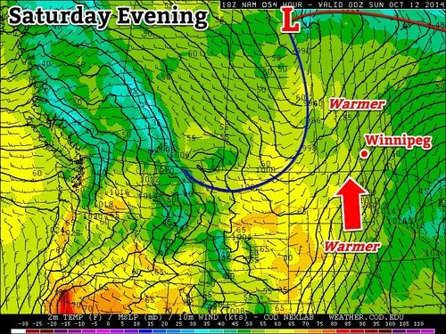
Tight gradient between the low over the northern MB/SK border and high pressure to our southeast will make for warm, gusty conditions on Saturday.
Friday
10°C / 2°C
Becoming mainly sunny late in the morning

High pressure to the southeast will make for calm conditions today, with mostly clear conditions and slightly below seasonal temperatures. Throughout the day the ridge will continue to shift eastward, making way for the next system arriving this weekend. With most of the cloud clearing out by late morning, giving way to sunshine it should turn out to be a fairly nice day with a tinge of chill in the air, as temperatures approach the 10°C mark. By the time Friday night rolls around, strong southerly winds will start to pick up as the next low pressure approaches to our north – a tight gradient between the high to our southeast and the low to our northwest will be in place.

Saturday
14°C / 7°C
Starting off sunny, possible afternoon cloud

Saturday looks to start off with plenty of sunshine but the downside will be the windy conditions. Winds will continue to gust throughout the day but temperatures will manage to climb to the low to mid-teens across Southern Manitoba. With that said, there is a chance for some stratus to move in from North Dakota in the early afternoon which means we might not heat out completely. The low Saturday night will be fairly mild thanks to some cloud in the region keeping things warm as well as the southerly flow staying in place – lows will be well above the freezing mark.

Sunday
15°C / 5°C
Mainly cloudy

By Sunday morning winds will have shifted to the northwest due to a cold front sweeping through the region in the morning. Although winds won’t be as strong as Saturday, they will continue to be gusty behind the cold front. Clouds are expected to linger throughout the day but there won’t be any significant precipitation. The temperatures will remain fairly warm, near average values – low teens are expected. Sunday night the low is will drop to the single digits, however, temperatures won’t drop below freezing.

Long Range

The Climate Prediction Centre as well as a few weather models show temperatures staying above normal for a good part of the beginning of next week with another low pressure system making its way across the Prairies and drawing in warm air ahead of it.

Red River Valley Set to Bake Today

Some of the hottest temperatures of the year will be seen today in the Red River Valley as extremely warm air is brought into the province by a low pressure system passing through the northern Interlake.

850mb temperatures from the GEM-REG

850mb temperatures from the GEM-REG for late this afternoon. Temperatures are expected to peak at just over 25°C at 850mb over the Red River Valley today.

Southerly winds have brought some of the warmest air yet this year over southern Manitoba. 850mb temperatures have climbed to 25°C today which, when combined with southerly winds at the surface, will help to push our daytime highs towards the mid-30’s. There is fairly good agreement among the models that winds will remain southerly in the Red River Valley through the day; this will eliminate any significant downslope effects and make temperature forecasting a little bit easier.

In general, daytime highs should range from 34-36°C through the RRV tomorrow, with the warmer temperatures closer to the American border. There is a slight chance that a few areas in the SW RRV could see highs push a degree or two higher than that (35-37°C), but such temperatures would be fairly localized. Winnipeg will have a chance of breaking it’s record high for today, which was set in 1972 when the temperature climbed to 36.1°C. It’s by no means a guarantee that we’ll break it, but we’ll certainly take a good run at it.

Dewpoints will climb to around the 18°C mark, however some areas may see dewpoints peak at 21-22°C before we start mixing air near the surface a little deeper into the atmosphere. This will result in humidex values between 39-45. It’s quite likely we’ll see a humidex advisory issued by the Winnipeg SPC later today.

Manitoba Health suggests Manitoba residents take precautions against heat-related illnesses whenever the humidex climbs above 37. Manitoba Health advises the following:

  • Stay aware and be prepared
    • Know daytime and night-time temperatures-both outdoors and indoors- by checking your local weather forecasts and the thermostat in your home.
    • Stay up to date on weather alerts so you know when to take extra-care.
    • If you have an air-conditioner, make sure it’s working properly before the hot weather starts.
  • Stay hydrated
    • Drink plenty of water (that’s the best liquid) before you feel thirsty.
    • Avoid alcoholic beverages, as they can increase the amount of water lost by the body.
  • Stay cool and keep out of the sun
    • Plan outdoor activities for cooler parts of the day, but remember to wear insect repellant since mosquitoes are out too.
    • If you are outdoors during the hottest part of the day, shade yourself from the sun with an umbrella or a wide-brimmed hat with lots of ventilation (to allow the sweat on your head to evaporate), wear loose-fitting, breathable, light-coloured clothing, and remember to wear sunscreen to limit ultra-violet (UV) ray exposure.
    • If there is no air-conditioning at home- go to a cool place such as an air-conditioned mall, public library, or community centre.
    • Take a cool bath or shower or go for a swim to cool off.
    • Avoid using your oven or other appliances that could heat your home more.
    • Limit physical activities during the hotter parts of the day or exercise in an air-conditioned place.
  • Take care of yourself and others
    • Check on family members, neighbours and friends – especially older adults and those with chronic conditions. Visiting is best because it is easier to identify signs of heat illness that could be missed over the phone.
    • Never leave people or pets in your care alone in closed vehicles or direct sunlight.

Heat and Your Health; Manitoba Health

A cold front will sweep through this evening, bringing more seasonal air back to the province. There is very little chance of any precipitation with the passage of this front.

The rest of the week will bring closer-to-seasonal temperatures with daytime highs near 28°C. The normal daytime high for Winnipeg for this time of year is about 22°C. The normal overnight low is around 9°C. Our blast of hot weather will likely ensure that Winnipeg has it’s 14th consecutive month with above-normal temperatures. We’ll have our regular post on Friday, and then two posts on Saturday: the regularly scheduled Elsewhere in Weather News and a climate summary of August/update on 2012.

A Beautiful Weekend Ahead

Our left-over moisture will slowly clear out today and tonight ushering in a beautiful weekend with plenty of sunshine and warm temperatures. With Winnipeg’s average daytime high sitting at around -8°C right now, we can expect to see tempeatures nearly 10°C above normal by the end of the weekend!

Sunny Skies

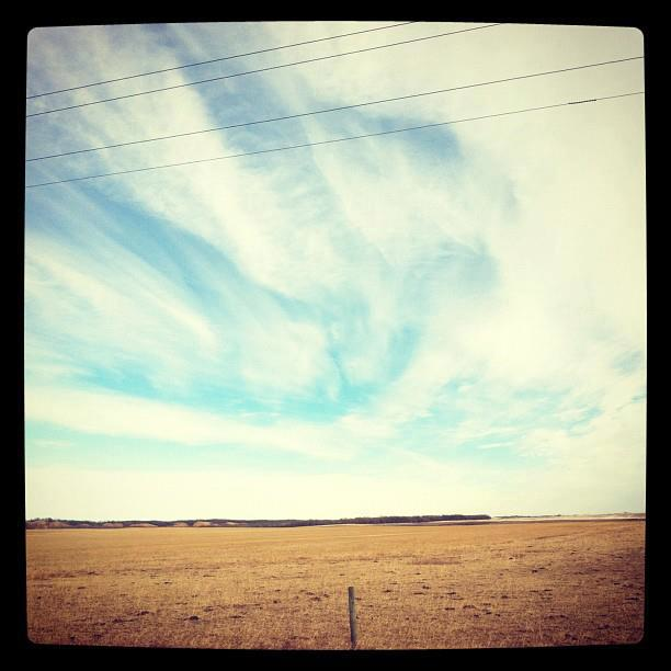
Many areas in Southern Manitoba that are typically covered in snow at this time of year are completely bare. PHOTO BY ERIN GARDIN.

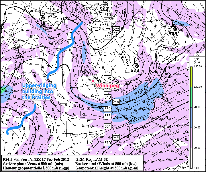
We’ll see a mix of sun and cloud here in Winnipeg today, with the ever-present chance of a few snowflakes, but any snow that does develop will be less significant than the few light flurries we saw yesterday in the city. The daytime high today will be cooler than yesterday, around -4°C, as a trough of cool air aloft swings over Southern Manitoba. The snow much of the Red River Valley recieved between 2 and 5cm of on Wednesday as a shortwave embedded in an upper trough swung across the province will not be sticking around for very long. An upper ridge has begun to build into the Prairies and will continue it’s trek into Southern Manitoba over the next two days. Here in Winnipeg, we’ll see winds switch around to southerly overnight tonight, which will usher in milder air and push our temperatures up for the weekend.

Upper Ridging

GEM-REG 500mb Winds valid 12Z Friday Feb. 17 (6AM CST)

We’ll see temperatures soar this weekend with a light south-southwest flow and mild air pushing in aloft. 850mb temperatures are expected to increase to slightly above 0°C by Sunday night, which will ensure that through the weekend we have daytime highs of 0°C – 3°C in Winnipeg.

Temperatures are expected to reach as high as +2°C this weekend; that’s 10°C above normal for Winnipeg at this time of year.

Any areas that manage to return to snow-free quickly will be able to add a couple degrees to those temperatures. Overnight lows will still be cool, with temperatures dropping down to around -11°C tonight and tomorrow night.

By Sunday, a low-pressure system will begin ambling it’s way out of Alberta into Saskatchewan. This will increase the southerly upper-level flow and provide the needed kick to really push those 850mb temperatures up. With the dramatically warmer 850mb temperatures in place, our overnight low on Sunday night will essentially be just a degree or two cooler whatever the daytime high makes it to.

The low will then track eastwards across Manitoba Monday into Tuesday. Models disagree significantly on what will happen happen for Winnipeg, with some giving us 5 to 10cm of snow and others keeping the precipitation 250 miles away from us. We’ll certainly keep our eyes on this system as it develops!