The Heat Builds In

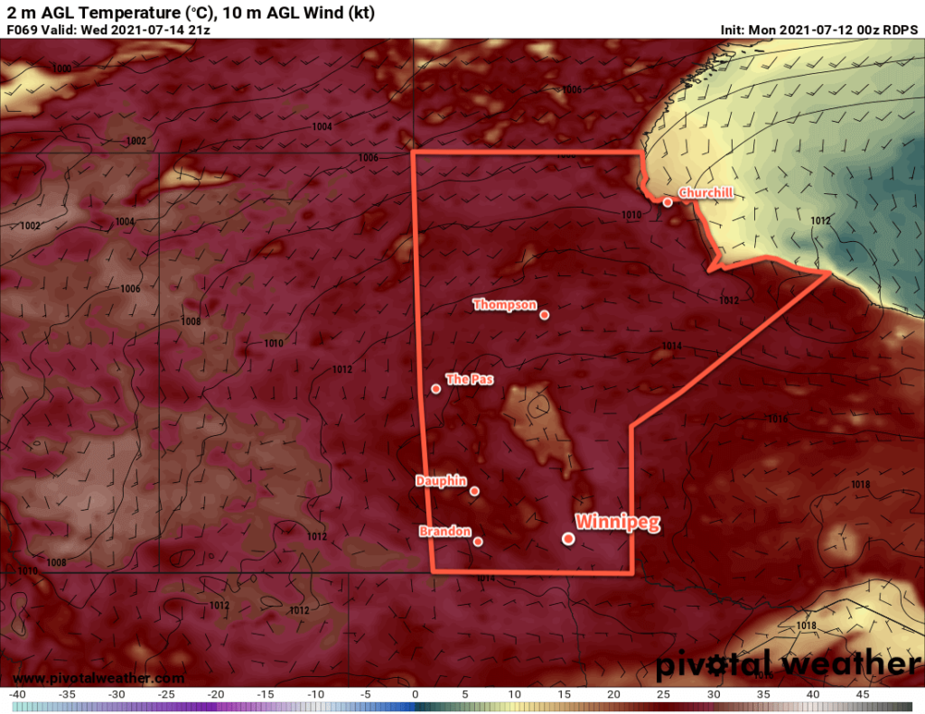
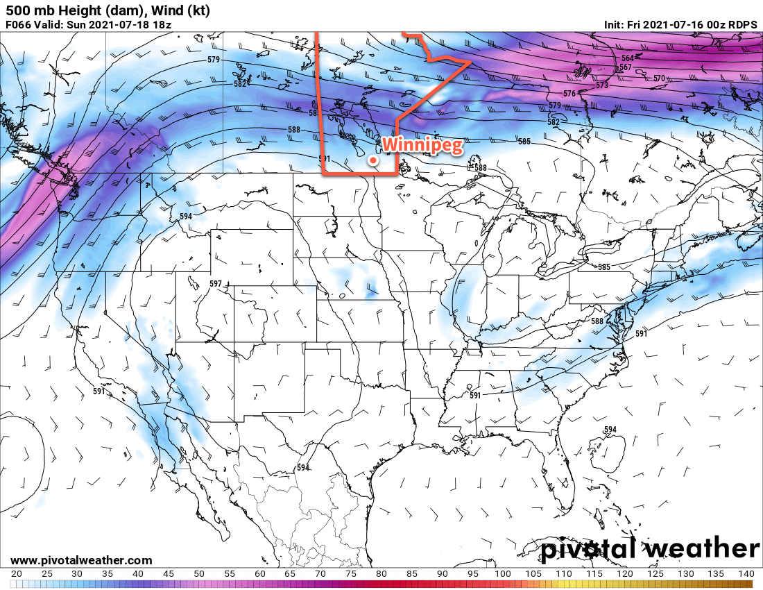
Winnipeg will see hot days ahead as an an upper ridge intensifies over the Prairies.

Winnipeg will see daytime highs climb to the mid-30s over the coming days as warmer air settles over the region. This warmth will be sustained by an amplifying upper ridge over the Prairies that will also keep conditions mainly sunny through the Red River Valley. Overnight lows will sit near 20 °C over the next couple days, then dip into the mid-teens on Sunday night as a cold front slumps into the region.

RDPS 500mb Height and Wind Speed Forecast valid 18Z Sunday July 18, 2021
An upper ridge will continue to amplify of the Prairies this weekend, extending northwards from the subtropical high over the western United States.

Winds will be breezy out of the south the next few days, picking up into the 20–30 km/h range during the day and easing at night. While conditions will be generally dry, an isolated pop-up shower or two can’t be ruled out over the coming days. The most organized chance for rain will be Sunday night when a cold front moves into the region.

Hazy conditions will persist over the coming days, with occasional periods of local smoke possible (the former being when smoke is mainly aloft with low concentrations near the ground, while the latter is when visibilities become reduced and the odour is noticeable).

The hot temperatures, relatively low dew points, and breezy winds will exacerbate the already poor fire conditions. Note that both the City of Winnipeg and the Province of Manitoba have fire bans in effect.

Long Range Outlook

Temperatures will cool slightly for Monday behind the cold front, then temperatures will rebound back towards the 30s on Tuesday. Models are starting to have a little more disagreement on how next week will progress. While all models had a significant heat wave for Winnipeg, newer model runs have become a bit more aggressive with the cooler air, keeping Winnipeg’s temperatures in the upper 20s or low 30s through much of next week. The hot weather will still be around, though, with highs climbing back into the mid- to upper-30s nearby to the west.

It’s hard to say at this point whether the new trend in the model will be right or not. If Winnipeg stays on the cooler side of this feature, then it will also mean the city will be more likely to see chances for rain or thunderstorms throughout the week. It’s impossible to discern at this point, though, so for now we’ll keep an eye on how this system evolves as the cold front slumps through the Prairies.

Today’s seasonal daytime high in Winnipeg is 26 °C while the seasonal overnight low is 13 °C.

Hot Weather Continues

Hot and increasingly dry conditions will continue to be the weather story for Winnipeg and the Red River Valley.

It’s only going to get drier across the Red River Valley this week as intense summer heat bakes the region. Winnipeg will see highs hovering around 30 or 31 °C through the first half of the week with lows in the upper teens.

Winds will be breezy out of the south today with southerly winds of 30–40 km/h picking up this morning. A trough will push across the region today, and while it supported widespread thunderstorms overnight, it will be less active as it moves into the Red River Valley. Winnipeg will see a chance of showers or thunderstorms beginning around lunch and persisting until early evening. If any thunderstorms are able to develop, they will have a small chance of producing severe hazards with primary threats of damaging wind and/or hail.

RDPS 2m Temperature Forecast valid 21Z Wednesday July 12, 2021
Winnipeg’s “cooling off” this week will be to highs near 30 °C. Hotter temperatures will return later this week.

Behind this trough, winds will shift to the northwest and then ease overnight. The northwesterly flow will usher in smokier conditions to the region once again. This time, the smoke will be coming from fires burning over northern Saskatchewan.

Tuesday and Wednesday will each bring light north-northeast winds and only a few clouds. The smoke, however, will likely stick around. While near-surface conditions will improve a bit, quite a bit of smoke will likely linger aloft over the region, casting that familiar slight orange hue under hazy skies.

Long Range Outlook

Another surge of hot air will move into the region for the second half of the week. Daytime highs will climb towards the mid-30s by the end of the week with overnight lows near 20 °C. While a couple shortwaves may meander over the region, an amplifying upper ridge should also keep the clouds at bay.

The forecasts show no notable precipitation for the Winnipeg area in the second half of the week or the weekend.

Today’s seasonal daytime high in Winnipeg is 26 °C while the seasonal overnight low is 13 °C.

Hot, Unsettled Weather Ahead

Winnipeg will see very hot and unsettled conditions heading through the weekend.

A low pressure system crossing the province today will send temperatures soaring in Winnipeg. South-southwest winds of 30–40 km/h will usher in a hot air mass with highs climbing into the mid- to upper-30s. The dew point will stay in the low teens which will mean, fortunately, that the humidity won’t make the heat feel any worse than it already is. A “cold” front will sweep southwards through the Red River Valley later today. This front will bring a risk of thunderstorms to the region as it passes, although the most likely area to see any convection will be south near the U.S. border. Winds will shift to the north behind the front and then ease overnight. Temperatures will head to a low near 18 °C.

RDPS 2m Temperature Forecast valid 18Z Friday June 4, 2021
Temperatures will climb into the mid-30s by lunch time today across portions of southern Manitoba.

On Saturday, moderate southerly winds will bring more hot weather back into the region as another low pressure system moves into the province. Temperatures will climb back into the mid-30s but this time humidity will accompany it. Dew points will climb into the mid- to upper teens, making it feel closer to +40 out. That heat and humidity will meet another cold front pushing into the Red River Valley late in the day. This combination will bring a risk of thunderstorms — potentially severe — to the region Saturday evening and overnight. Temperatures will head to a low near 19 °C.

3km NAM Simulated Reflectivity Forecast valid 07Z Sunday June 6, 2021
Many weather models show the potential for nocturnal thunderstorm development on Saturday night into Sunday morning.

Drier, slightly cooler air will work into the region on Sunday. The morning will start with some lingering cloud with a chance of showers or thunderstorms as the cold front slowly continues to push through the valley. It should be off to the east by late in the morning with skies clearing for the afternoon. Temperatures will climb to a high near 27 °C with a moderate westerly wind bringing more comfortable humidity levels to the region. Skies will stay clear on Sunday night with a low near 14 °C.

Long Range Outlook

Next week will start with mainly sunny skies and highs near 30 °C again. Forecasts show more unsettled conditions developing mid-week, then gradual cooling back towards seasonal values by the weekend.

Today’s seasonal daytime high in Winnipeg is 22 °C while the seasonal overnight low is 9 °C.

Blazing Heat Building In

Temperatures will soar in Winnipeg through the second half of the week as a potent upper ridge builds across the Prairies.

The heat will be remarkable for early June as temperatures climb through the 30s over the next few days. The heat will likely challenge records for the Winnipeg area, particularly on Thursday and Friday. Thursday’s high of 33 °C will challenge the existing record of 32.8 °C set in 1968. Friday’s intense push of heat will send highs into the upper 30s and likely break the existing record high of 35.6 °C set in 1988. The overnight lows may even challenge record warm minimum temperatures which sit at 18.3 °C for both June 4th and 5th, set in 1976.

Environment and Climate Change Canada has issued a heat warning for much of southern Manitoba. Tips to beat the heat can be found on the City of Winnipeg’s emergency preparedness page.

RDPS 2m Temperature Forecast valid 21Z Friday June 4, 2021
Temperatures will be very hot over southern Manitoba on Friday with highs in the 35–40 °C range.

The city will see plenty of sun throughout the next few days. The most notable non-heat element of the weather will occur overnight into early Thursday morning. A strong upper-level jet will generate some showers and/or thunderstorms over the northern Prairies on Wednesday afternoon. This cluster of instability will move southwards into southern Manitoba through the evening and overnight hours. Winnipeg will see a chance of showers or thunderstorms overnight with the highest chance after midnight. These storms won’t have any organized risk of severe weather, but dry low-levels mean that some moderate to strong wind gusts will be possible with them as they move through.

Some lingering cloud from these systems will stick around on Thursday morning, then skies should clear for the afternoon.

Long Range Outlook

The heat will continue with daytime highs in the 30s on Saturday, then highs will ease back into the upper 20s Sunday into next week. Conditions will also turn more unstable this weekend, with an increasing chance of showers or thunderstorms beginning Sunday night and persisting into next week. The above-seasonal warmth will persist right through next week with highs in the mid- to upper-20s and lows of 15–20 °C.

Today’s seasonal daytime high in Winnipeg is 22 °C while the seasonal overnight low is 9 °C.