Summer Weather on the Way

After another stretch of below-normal temperatures, some truly summer-like weather is finally on the way.

Winnipeg will be under the influence of a ridge of high pressure that will keep us dry through the remainder of the week. A developing flow from the Gulf of Mexico looks poised to set up Southern Mantioba for a quick shift into summer-like weather for the end of the week.

Wednesday
15°C / 6°C
Mixed skies with a clearing trend.

Thursday
23°C / 12°C
Mainly sunny.

Friday
26°C / 14°C
Mainly sunny.

Today will bring mixed skies to Winnipeg and the Red River Valley as the system cloud associated with the low that moved through on Monday and Tuesday begins exiting the province. Cloud will likely persist through the afternoon as some fair weather cumulus develop as we warm up to our high near 15°C. Skies will clear tonight as the temperature drops. The temperature will drop to around 6°C tonight.

Tomorrow will bring mainly sunny skies, relatively light winds and a high temperature returning to a seasonal to slightly above seasonal 22 or 23°C. Things will be calm and mainly clear Thursday night with temperatures dropping to near 12°C.

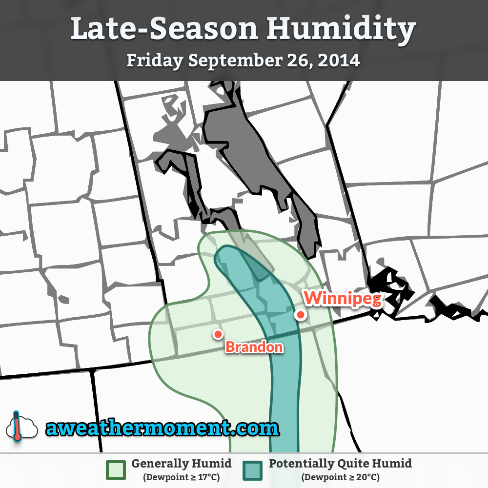
Friday will mark the shift towards decidedly more summer-like weather. Under mainly sunny skies, warmer air pushing into the region will push our daytime high towards around 26°C. In addition to the warmer weather, we should also see the first days of the year that could potentially be considered “humid.” For a quick summary of the relationship between dew point and how humid it feels, and why relative humidity is a poor choice, check out the brief primer at the bottom of this post.

There’s uncertainty in exactly how humid it will get here in Southern Manitoba. Some weather models, such as the Canadian GDPS[1] are pushing dew point values as high as 20°C in the Red River Valley, but values that high are likely overdone thanks to the delayed start to the growing season due to the abnormally cold spring. It’s likely we see dew points climb into the mid-teens at least, though, so it’s fairly safe to expect that we’ll be seeing our first real shot of summer heading into the weekend.

Unsettled Weekend

There’s still a lot of uncertainty associated with the large amplitude upper-level pattern that’s expected to develop this weekend, so in general vagueries…

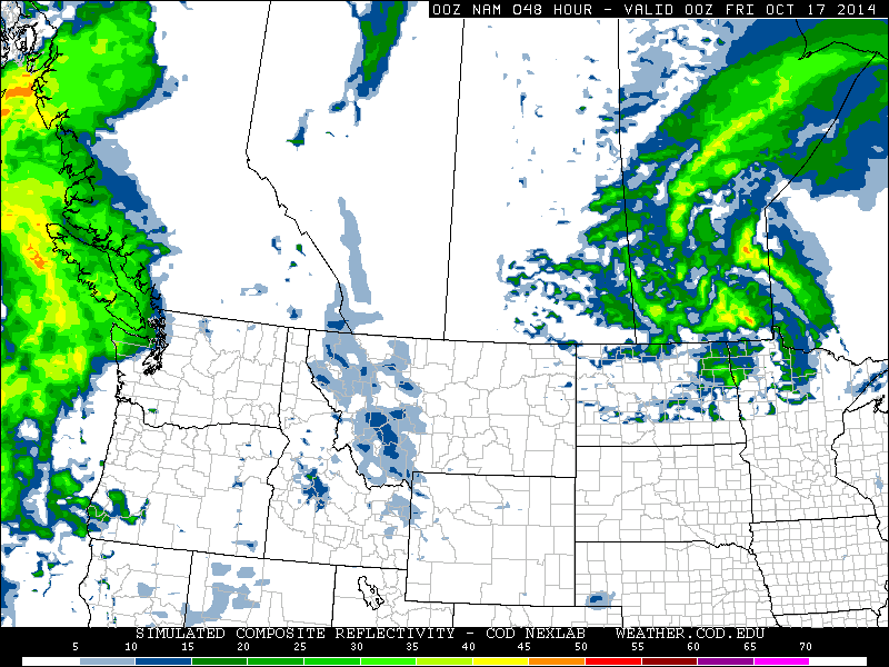
As the NAM shows, a broad flow from the Gulf of Mexico all the way to Southern Manitoba will be established by Saturday morning.

It’s going to be quite warm on Saturday. Daytime highs in the upper 20’s seem quite likely as well as dew points climbing into the mid-to-upper teens, although as mentioned above, there’s some uncertainty to exactly how high the dew points will get. Sunday will also be warm with highs in the mid-20’s.

Thunderstorms, potentially severe, will be possible both days, although exactly when and where is far too uncertain at the moment. It seems entirely possible that the thunderstorm activity will be constrained to the evening/overnight periods when elevated thunderstorms can develop, although late afternoon severe storms cannot be ruled out at this point. For both days the best chance for thunderstorms appears to be over Parkland Manitoba, SW Manitoba and into SE Saskatchewan and Montana/North Dakota. Here in the Red River Valley, nocturnal elevated activity looks like the most plausible scenario.

We’ll be taking a closer look at the thunderstorm and severe weather potential in Friday’s post. Until then, enjoy the imminent summer weather!


A Quick Lesson on Dew Points

Perhaps the most convenient way to quantify how humid it is outside is to look at the dew point temperature. The dew point is the temperature where water evaporates into the air at the same rate that it condenses out of the air; to put that in simpler terms, if the air comes in contact with something cooler than the dew point, water will condense out of it. Think of it as the temperature your cold glass of your favorite hot weather beverage needs to be to “sweat”.

The higher the dew point temperature is, the more water is in the air. This is an important distinction from relative humidity. Air has a quirky trait that allows it to hold more water the warmer it is. This means that air at -5°C cannot hold as much water as air at 25°C. This makes relative humidity ambiguous since it is a measure of how much water is in the air versus how much water the air can hold, or “how full the glass is.”

So a relative humdity of 100% at -5°C has less water in the air than a day where the temperature is 10°C with a relative humidity of 35% because the dew point in the first case is -5°C, while in the second case, despite the relative humidity of only 35%, the dew point is around -4.8°C.

As the dew point climbs, your perception of it being humid increases as well. In general, once the dew point rises to around 15 or 16°C, you’ll begin to notice that it feels humid. By 18 or 19°C it can begin to be uncomfortable. By the time the dew point climbs into the low-to-mid 20’s, as long as there’s sunshine, it can be extremely sticky feeling outside. Dew points in excess of 25°C are dangerous and can pose extreme health risks.


  1. Global Deterministic Prediction System  ↩

Incoming Mild Air Brings Unsettled Weather

A textbook frontal passage is in store for the Red River Valley over the next few days as an incoming warm front brings a chance of flurries and another mild day before the cold front slumps through the region at week’s end, bringing another windy chance for snow.

Wednesday
-10°C / ⇑ -3°C
Cloudy, light flurries starting midday.

Thursday
+4°C / -7°C
Warm with mixed skies. Windy with flurries overnight.

Friday
-6°C / -20°C
Chance of early morning flurries, otherwise mainly sunny.

We’re off to a cold start this morning, but temperatures will soar today as a strong warm front pushes across the Red River Valley. Southerly winds will pick up through the day to around 30-40km/h by mid-afternoon. There will be a chance of flurries beginning midday and lasting through the early evening. No significant accumulations are expected and thanks the warming temperatures and recent melting, blowing snow should be minimal. Temperatures will climb to around -10°C by evening but continue rising through the overnight period to nearly -2°C by Thursday morning.

Mild air is set to push into Southern Manitoba again on Thursday.

Thursday will be another beautiful day very reminiscent of Monday this week. Winnipeg will see relatively light winds and mixed skies as the temperature climbs all the way to 4°C. Similar to Monday, there will probably be significant variation across the city with some places climbing several degrees higher to 7-8°C.

Things will take a less pleasant turn on Thursday night when a cold front slices through Southern Manitoba. Gusty winds out of the northwest to 40km/h will accompany some flurry activity that will spread into the Red River Valley from north to south through the mid-to-late evening hours. The wind and any straggling flurries should taper off early Friday morning.

Friday sees an Arctic ridge of high pressure building into Manitoba bringing cooler temperatures with it. In Winnipeg, temperatures will be some 10°C cooler than Thursday with a daytime high only near -7 or -6°C under mainly sunny skies.. Winds will remain light and the temperature will drop close to -20°C on Friday night.

Cool Weekend Ahead

Temperatures will remain well below normal through the weekend in the Red River Valley. Saturday’s high looks to be near -15°C under mainly sunny skies while Sunday sees the coldest axis of air shifting off to the east, allowing temperatures to climb to the low minus single digits with a few cloudy periods.

In the southwest corner of the province, flurries will be possible numerous times over the next 5 days as the main frontal zone sets up across the region and weak disturbances ripple along it.

Unsettled Pattern Continues

Residents in the Red River Valley have barely had time to get the shovels out after Wednesday’s snowfall and Thursday’s blowing snow/blizzard, but more snow and wind is on the way as another system tracks through today. The unsettled weather will continue through the weekend with a brief improvement on Saturday followed by more unsettled weather on Sunday.

Friday
-8°C / -10°C
Increasing cloud in the afternoon then snow. 4-8cm accumulation.

Saturday
-7°C / -9°C
A mix of sun and cloud. Blowing snow in the morning. Chance of flurries.

Sunday
-5°C / -20°C
Light snow developing through the day.

Another Shot of Snow Tonight

More snow is on the way later today through tonight as another low pressure system dives southeastwards through the province. Before that, though, we’ll see mainly sunny skies with relatively light winds out of the south at only around 20-30km/h by the afternoon. The temperature should climb up to around -8°C in Winnipeg while areas closer to the U.S. border may see the temperature get as high as -5°C or so.

Expected storm-total snowfall amounts by Saturday morning.

Cloud and snow will stream in fairly quickly from the northwest later this afternoon as the low pressure system begins slumping southwards through the Interlake. The heaviest snowfall will fall before midnight with lighter flurries persisting thereafter into the early morning. The snow will taper off by tomorrow morning with totals generally between 4-8cm through Winnipeg & most of the Red River Valley.

Blizzard conditions may develop in the southwestern Red River Valley thanks to the funnelling effect of the western escarpment.

Winds won’t be as strong as Wednesday through the snowfall event – around 30km/h gusting to 50 or so in Winnipeg and the eastern Red River Valley and a little bit stronger in the western Red River Valley at around 40 gusting 60km/h. There will be some blowing snow through the overnight period, but I don’t think we’ll see anything as extensive as on Wednesday night into Thursday. The one caveat may be the southwestern Red River Valley[1] where blizzard conditions may develop thanks to a funnelling effect of the western escarpment. Winds may climb up to 50 gusting 70km/h which should be enough to produce a widespread white-out. The strong winds will move in overnight and taper off midday tomorrow.

Nice Start to Weekend, Snowy End

Skies will clear out early Saturday morning with any blowing snow hanging on a little longer until the winds die down. Otherwise we’ll see mixed skies with a high near -7°C with fairly light winds. There will be a slight chance of a flurry or two, but no accumulations are expected.

We’ll drop to an overnight low of just -9°C[2] as more cloud cover begins working it’s way in ahead of another disturbance on it’s way. There will be a continued chance for some isolated flurries overnight.

Sunday will be a mainly cloudy day with snow developing through the afternoon. We’ll climb up to a high of around -5°C. The snow will taper off through the evening on Sunday with some breezy northerly winds producing some blowing snow through the Red River Valley. At this point it doesn’t look too bad, fortunately. Skies will clear Sunday night and we’ll drop to an overnight low of around -20°C.

We’ll continue on an unsettled track through next week as very cold Arctic air begins pushing it’s way back into the region. It seems like we’ll be seeing overnight lows near -30 to -35°C in the latter half of the week, so enjoy the upcoming mild weather!


  1. Areas near Carman, Altona, Winkler, Morden, and Emerson are most likely.  ↩
  2. An overnight low that’s warmer than our normal daytime high for January 17th!  ↩

Mild Weekend Welcome, But A Mixed Bag Otherwise

Temperatures over the next few days will be positively balmy for early January in Winnipeg as daytime highs near -5°C over the next few days keep us well over the normal high of around -13°C for this time of year. The warm temperatures are a welcome reprieve from the bitter cold that has gripped the province over the last month, but the other aspects of the weather will be a bit of a mixed bag over the next few days as multiple low pressure systems move through the region.

Friday
-5°C / -15°C
Cloudy with flurries beginning midday. Clearing overnight.
Saturday
-7°C / -12°C
Mixed skies and a bit cooler.
Sunday
-3°C / -15°C
Mixed skies with a chance of flurries in the morning and evening.

Today will be a pleasant day with fairly light winds and a high of around -5°C. Skies will remain cloudy through the day and we’ll likely see some scattered flurries develop through the Red River Valley midday as a very weak low pressure system pushes through. This evening will see any remaining flurries push off to our east with clouds scattering out overnight as we drop to a low of around -15°C.

Saturday will be a slightly cooler, thanks to a weak ridge passing over the Red River Valley, but nice day with a mixed sky and a high near -7°. We’ll drop only to around -12°C Saturday night as a warm front moves through the area associated with an incoming clipper system from Alberta. A band of light snow should push through the Red River Valley overnight into early Sunday morning with no real significant accumulations other than perhaps a couple centimetres here or there; the bulk of the snowfall will remain in the Interlake where around 2-5cm of snow is expected. Perhaps the bigger impact of the system will be the strong winds that move into the region on Saturday night; we’ll see them increase out of the south to 40 gusting 60km/h which will likely produce some blowing snow on highways throughout the Red River Valley.

After things clear out on Sunday morning we’ll actually be in for quite a nice day with a high near -3°C. Skies will be mixed for much of the day before more cloud moves into the area in the evening hours as a cold front slumps southwards towards the Red River Valley. The chance for some light flurry activity will re-emerge on Sunday evening with the passage of the cold front but as with the rest of the features this weekend, no significant amounts are expected.

Warmer weather is expected to continue through much of next week. A storm system is currently forecast to move through on Wednesday night, which could bring blizzard conditions to the Red River Valley thanks to very strong northwesterly winds, will likely bring cooler weather for the week’s end. We’re no longer in a relatively static upper-level pattern, though, so the cold air will continue trundling off to the east fairly quickly instead of sitting around here for a prolonged period.